
Route: Rannerdale Knotts
Area: Western Lake District
Date of walk: 22nd June 2023
Walkers: Andrew, Gilly, Tom, Charlotte and baby Finley
Distance: 3.0 miles
Ascent: 1,100 feet
Weather: Sunny
Rannerdale Knotts is one of the smallest lakeland fells, standing at the modest height of 1,160 feet. What Rannerdale Knotts lacks in height it more than makes up for in its rugged mountainous character and the beauty of its surroundings
We made an early start and parked in the small National Trust car park at Hause Point. From here the ascent starts almost immediately. Within a few minutes there were lovely views over Crummock Water and Buttermere. It’s a steep climb but made much easier in recent years thanks to the addition of a rock staircase. We were soon on the north top of the fell enjoying good views over Crummock Water. Nephew Tom was carrying six month old Finley in a baby back pack and today was Finley’s first Wainwright, but he knew nothing about it as he’d fallen asleep – he’ll have to do it on his own two feet one day
We set off along the knobbly summit ridge, clambering down a slightly awkward gully at one point. There are lovely views of both Crummock Water and Buttermere along the way. Eventually we reached an easier grassy section known as Low Bank. At the end of the ridge there’s a fork in the path and choice of return routes – either left along Rannerdale or right, along a path which heads towards Buttermere and then turns towards Crummock Water side. We opted for the former today, as it’s slightly shorter and my new knee, replaced four months ago, was starting to suffer. Click here to see the alternative route and here to see the famous Rannerdale bluebells, which would be over by now. If walking this route in May the return via Rannerdale and its bluebells is unmissable
We descended down High Rannerdale and entered the bluebell area at a footbridge over Squat Beck, which we didn’t cross. It just remained to walk below the crags of Rannerdale Knotts to the end of the walk near the shore of Crummock Water
For other walks here, visit my Find Walks page and enter the name in the ‘Search site’ box
Click on the icon below for the route map (subscribers to OS Maps can view detailed maps of the route, visualise it in aerial 3D, and download the GPX file. Non-subscribers will see a base map)

Scroll down – or click on any photo to enlarge it and you can then view as a slideshow

One for the family album. Our nephew Tom, Charlotte and six month old Finley at the start of the walk

From the car park at Hause Point we follow the Buttermere road but only for a few paces, before branching off left up a rocky path

An early view back along Crummock Water, with Low Fell in the background

Mellbreak at the far side of Crummock Water

Buttermere comes into view beyond the head of Crummock Water

Looking down to Rannerdale Farm. Another lake appears in the distance - Loweswater mid left of picture

Looking back

A US Air Force F-15 Strike Eagle, one of three on a training exercise, thunders by - but fails to wake baby Finley

Crummock Water and Loweswater

Another for the family album at one of the rocky platforms on the way up

More views along Crummock Water as we gain height...


Red Pike, first on the list for anyone tackling the High Stile Range

We arrive at the rocky summit area of Rannerdale Knotts

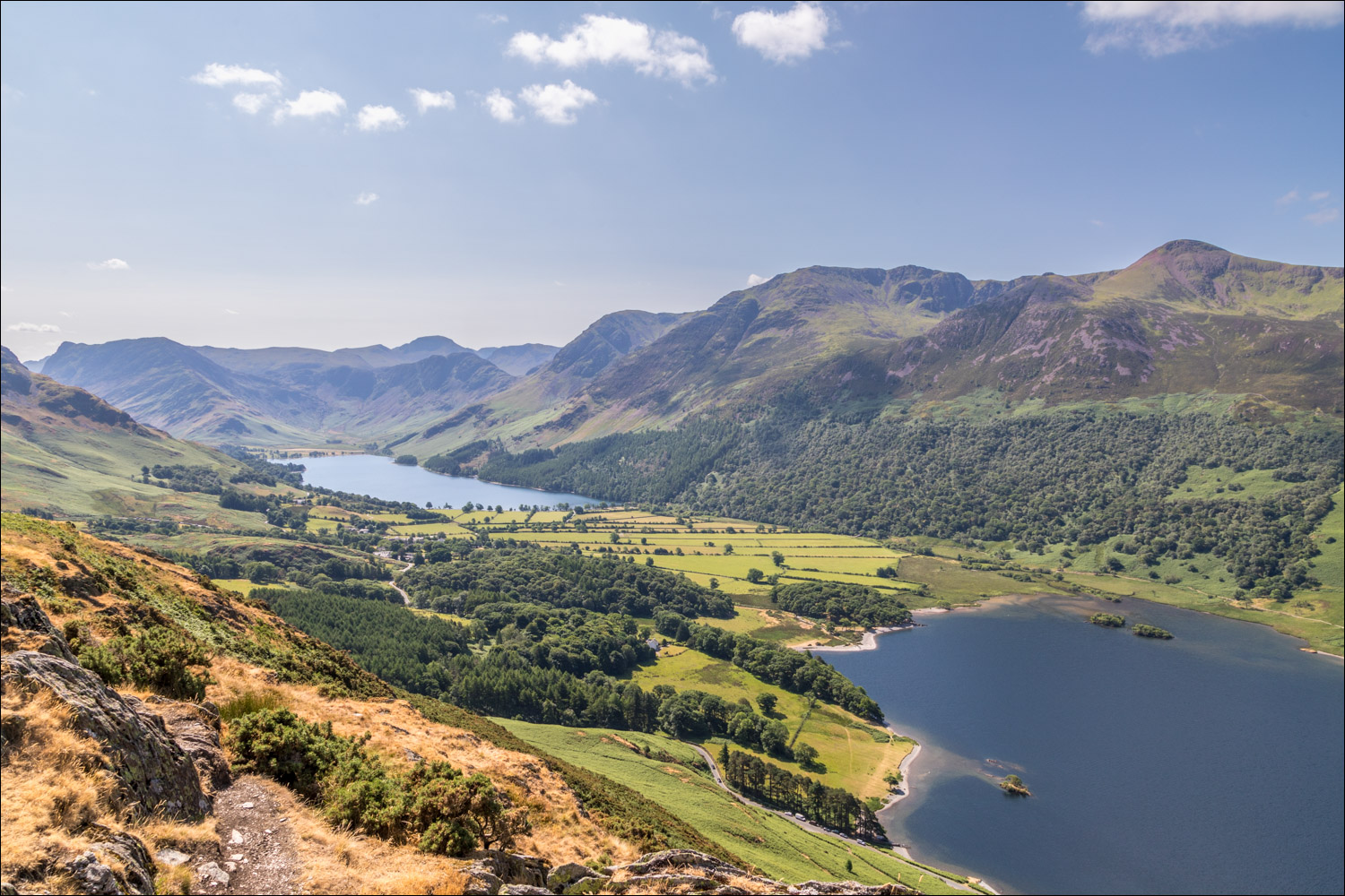
Crummock Water and Buttermere flanked by the High Stile Range

The head of Crummock Water and the foot of Buttermere from Rannerdale Knotts

Small cairn on Rannerdale Knotts, looking towards Mellbreak

Grasmoor and Whiteless Pike

Gilly sets off along the undulating rocky ridge...


Looking back

Views of Buttermere along the way...


We approach the end of the ridge at a grassy area known as Low Bank

Turn left for Rannerdale, or right for Buttermere

After turning left at the junction we descend along High Rannerdale

The easy descent along Rannerdale...


We enter the bluebell area via this gate and turn left, ignoring the bridge over Squat Beck

We skirt around the lower edge of Rannerdale Knotts

Crummock Water comes into view, and the end of a wonderful walk is just around the corner
