
Route: Brackenthwaite Hows
Area: Western Lake District
Date of walk: 14th June 2023
Walkers: Andrew and Gilly
Distance: 3.0 miles
Ascent: 800 feet
Weather: Sunny and very hot
As regular visitors may know, I underwent a partial knee replacement operation last February. Following advice from my physiotherapist I decided to test the progress of my recovery by repeating a walk in Lorton Vale which we followed in April. On that occasion I’d done too much too soon and was in pain for the rest of the day. Would my knee pass the test today?
Brackenthwaite Hows, otherwise known as Lanthwaite Hill, is situated near the head of the vale. This place has featured on my site many times, but I take the view that no two walks are ever the same – changing seasons and variations in the light and weather make for an infinite number of possibilities – and there’s always something new to be seen
As on the last occasion here we parked in one of the free spaces by Lanthwaite Green Farm. We crossed the Buttermere road and headed towards Whin Ben, a ridge which leads up to Whiteside. After crossing the footbridge over Liza Beck we followed the delightful path above Lorton Vale. It felt wonderful to be striding out along this familiar path, with lovely views along the valley. We kept a sharp lookout for Beck House on our left and when we drew level with it we left the valley path and passed through a gate. The path descended to an area before Liza Beck, which is normally very boggy. Today it was dry for once thanks to a recent heatwave and lack of rain. We crossed the beck via a footbridge for the second time and immediately after that crossed the Buttermere road. We passed by Pickett Howe and started the easy climb up the slopes of Brackenthwaite Hows, following a faint path not shown on the OS maps
We were soon on the top of the hill admiring the views in all directions – Crummock Water and the western fells ahead, Loweswater on the right, Lorton Vale stretching out behind us and Whiteside and Grasmoor on the left.
We descended towards Crummock Water and entered Lanthwaite Wood via a deer gate. We then followed a path beside a dry stone wall at the edge of the wood. Near the edge of the wood we followed a path out of it back to Lanthwaite Green and to the end of the walk. I’m pleased to report that the walk was completely pain free and the knee passed its test with flying colours. The walk was as wonderful as ever and in the course of two hours we didn’t see another soul
For other walks here, visit my Find Walks page and enter the name in the ‘Search site’ box
Click on the icon below for the route map (subscribers to OS Maps can view detailed maps of the route, visualise it in aerial 3D, and download the GPX file. Non-subscribers will see a base map)

Scroll down – or click on any photo to enlarge it and you can then view as a slideshow

Mellbreak seen from the parking space by Lanthwaite Green Farm

We head in the other direction, crossing the Buttermere road, and head towards Whiteside

Looking back to the start, with Crummock Water appearing below Mellbreak

We cross the footbridge over Liza Beck and head along the foot of Whin Ben, which leads up to Whiteside

A view back along our path

We continue beside the dry stone wall which runs along much of Lorton Vale

Another view back

We continue along Lorton Vale until we reach the house which can just be seen mid picture on the left

Looking across to our objective, Brackenthwaite Hows, which is the hill in the foreground

We leave the valley path here and turn left through this gate

We walk through this field beside the dry stone wall

At the end of the field we cross the footbridge over Liza Beck and then cross the Buttermere road again

We walk past Pickett Howe and just after passing through a gate we start the gentle climb up the slopes of Brackenthwaite Hows

Looking across to Low Fell...

...and now looking back to Whiteside

We follow the ridge of Brackenthwaite Hows as it curves around to the top, right of picture

The High Stile Range in the background

Gilly heads for the top of the hill

A fighter jet, one of a pair, passes overhead, part of a training exercise. I think it's an F15 Eagle

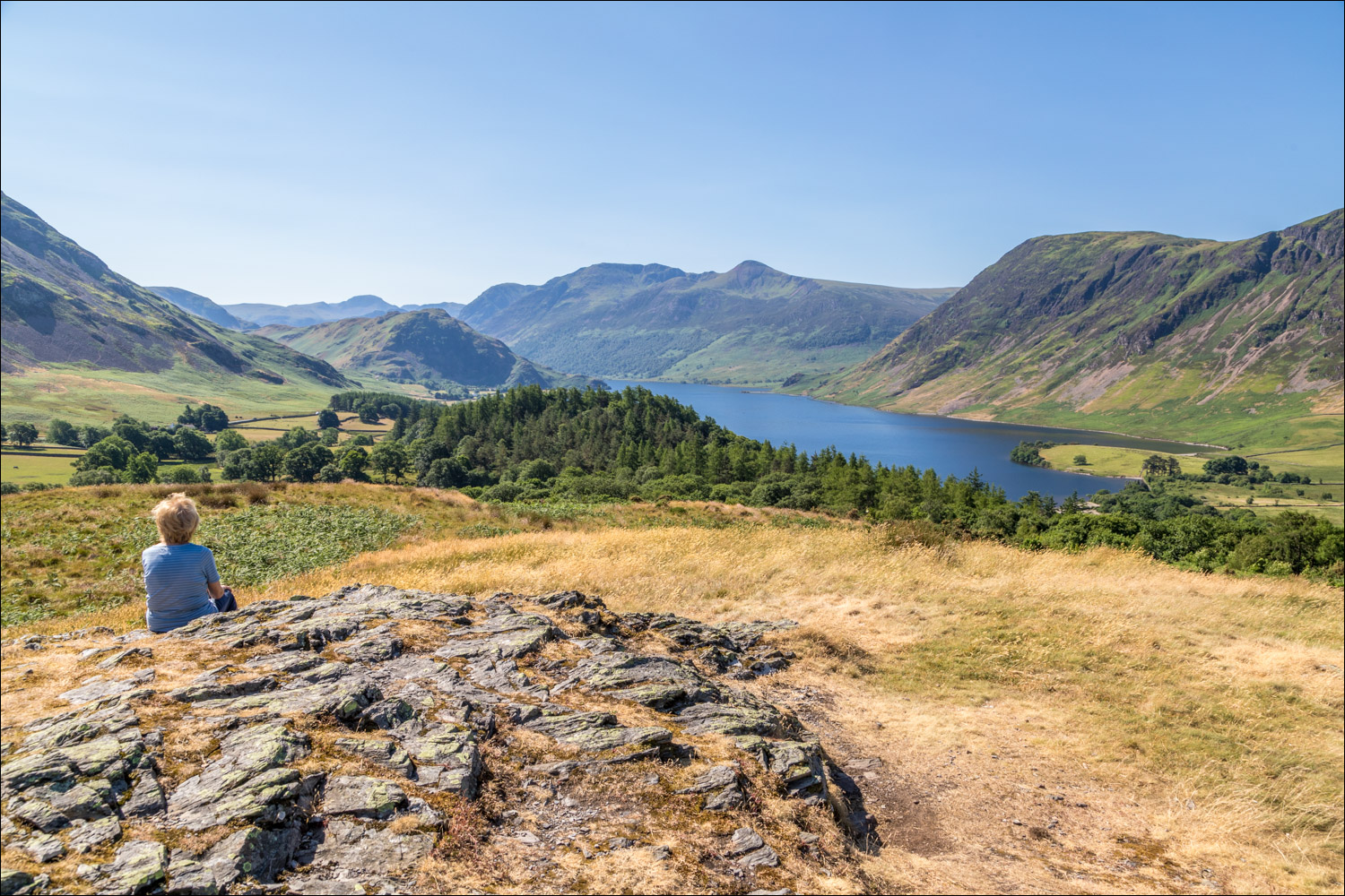
Crummock Water from a rocky platform below the top

Mellbreak and the foot of Crummock Water

Lorton Vale

Loweswater from Brackenthwaite Hows

Crummock Water

We descend in the direction of Crummock Water and head into Lanthwaite Wood below

We follow a path around the edge of the wood

Looking across to Whiteside

We leave Lanthwaite Wood here and follow a path towards Whiteside and Lanthwaite Green

Lanthwaite Green Farm ahead, and the car park is just to its right
