
Route: Mirehouse and Bassenthwaite Lake
Area : Northern Lake District
Date of walk: 10th August 2023
Walkers: Andrew, Gilly, Phil and Denise
Distance: 3.0 miles
Ascent: 150 feet
Weather: Mostly sunny
Mirehouse is a historic property in the heart of the northern Lake District. It was built in 1666 by the Earl of Derby, who sold it in 1688. Since then it has never been sold and has passed by inheritance. The house is open to visitors, check the website for opening times and prices. The grounds are also open for visitors and provide good walking opportunities. We parked in Dodd car park, which is opposite Mirehouse, and which is home to the Old Sawmill Tearoom
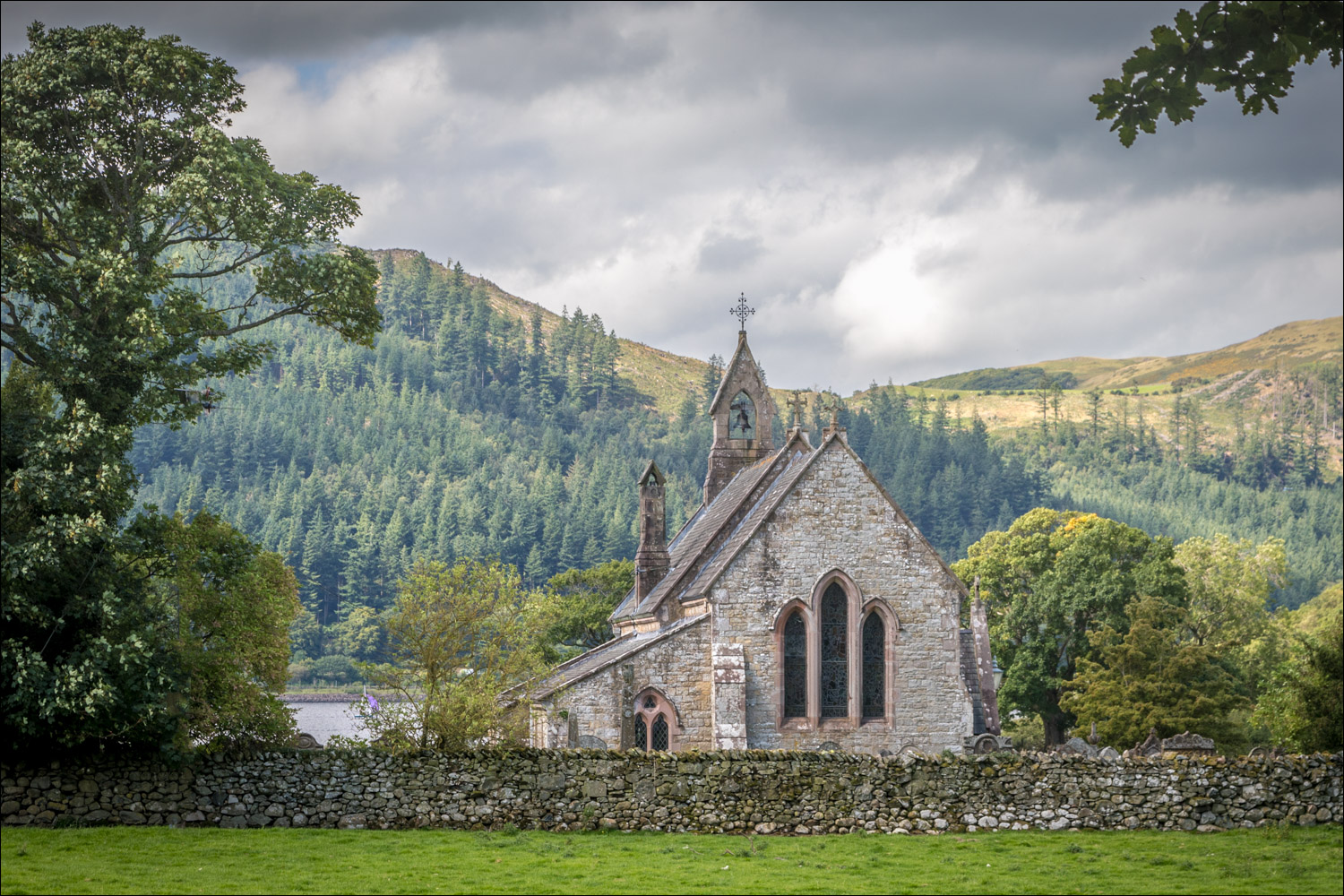
Having purchased tickets to the grounds, we crossed the road and followed the drive towards the house, which is lined with some magnificent Scots pines, some of them dating back to 1786. Just before reaching Mirehouse we made a short diversion to the Bee Garden, a walled garden planted to benefit honeybees. We returned to the drive, passing by the house, and followed Lovers’ Lane, so called because match-makers used to send likely couples down this romantic path. We then entered into the parkland and visited ancient St Bega’s Church, set in a wonderful position near the shore of Bassenthwaite Lake. The building dates back to AD 950 and is widely visited by people from all over the world. In recognition of this the church has a collection of Bibles in 28 languages
We returned through the parkland and joined a path leading through Catstocks Wood to the shore of Bassenthwaite Lake. The path continued through the wood, initially with limited views, but beyond the wood there were lovely views across the lake to Barf and Seat How and, further down the valley, the distinctive knobbly tops of Causey Pike and Catbells. We turned away from the lake to follow a path back towards Mirehouse which took us through Crosthwaite Wood and from there back to the start of an excellent short walk
Click on the icon below for the route map (subscribers to OS Maps can view detailed maps of the route, visualise it in aerial 3D, and download the GPX file. Non-subscribers will see a base map)

Scroll down – or click on any photo to enlarge it and you can then view as a slideshow

Having bought our tickets at the Dodd Wood car park we cross the road and enter the grounds of Mirehouse

We walk along the drive, passing by some magnificent old scots pines...


We make a short diversion into the Bee Garden

The sheltered walled garden was created in 1780 and has been planted to benefit honeybees


Mirehouse, which can be visited (check the website for ticket information)

The ancient wildflower meadow at the front of the house has recently been cut for hay

We follow the path known as Lovers' Lane

We pass by a waterfall in Skill Beck

Bassenthwaite Lake appears as we enter into the parkland

St Bega's Church, the oldest church building in the Lake District, set in a wonderful position near the shore of Bassenthwaite...


Ullock Pike, with Skiddaw beyond but out of sight

We retrace our steps across the parkland and turn right into Catstocks Wood

After following the woodland path for a while we arrive at the shore of Bassenthwaite Lake


We then turn back inland to head back to the start

A final glance back to Bassenthwaite

Back to the end of a lovely short walk
