
Route: Low Fell and Loweswater
Area: Western Lake District
Date of walk: 1st August 2019
Walkers: Andrew
Distance: 8.7 miles
Ascent: 2,000 feet
Weather: Mostly sunny, warm
Today’s Plan A was Haystacks, but as I drove over in that direction the fells were shrouded in thick cloud. In contrast the fells further west were bathed in sunshine. Time for a re-think. It didn’t take me long to come up with Plan B – Low Fell and Loweswater. I hadn’t decided on the precise route yet, and would make it up on the hoof, depending on weather conditions. I parked as usual in the small layby just outside Thackthwaite. After walking into the village I turned right to follow the signed path uphill. There are good views back over Lorton Vale during this early section of the walk
I soon arrived on the undulating ridge of Low Fell. The views from here are wonderful all the way along, but the very best vantage point is at the furthest end. Anyone who turns back when reaching the north summit cairn is missing the whole point of the walk. The view from the cairn just below the south summit is described by Wainwright as a ‘view of classical beauty, an inspired and inspiring vision of loveliness…..a scene of lakes and mountains arranged to perfection’. Although I’ve been up here many times, I never tire of this scene and stood here in awe for some time taking in the view, before reluctantly turning away to retrace my steps for a short distance
The next fell, Darling Fell, is not a Wainwright although in some ways it deserves to be, as the views from here rival those from Low Fell. However, it’s a steep descent and an energy sapping ascent before they can be enjoyed. From here I descended west, with hazy views of the Irish Sea in the distance. The path shown on the OS map does not accurately record the location of the path on the ground, but there are no navigation difficulties and route finding is straightforward
I eventually arrived at the old Mosser Road. From here it would be quicker to walk along the lane beside Loweswater, but I preferred to take the longer route around the far shore of the lake. I followed the path through Holme Wood and on reaching Watergate Farm followed the track to the small car park at Maggie’s Bridge
From this point the remainder of the return journey was along quiet country lanes. This didn’t detract from the enjoyment in any way – there was hardly any traffic at all, perhaps 3 cars in as many miles, and there are some lovely views along the way. It was a wonderful way to end a wonderful walk
For other walks here, visit my Find Walks page and enter the name in the ‘Search site’ box
Click on the icon below for the route map (subscribers to OS Maps can view detailed maps of the route, visualise it in aerial 3D, and download the GPX file. Non-subscribers will see a base map)

Scroll down – or click on any photo to enlarge it and you can then view as a slideshow

Earlier in the day, a dawn visit to the head of Crummock Water

Later in the morning, I walk into Thackthwaite to start the climb up to Low Fell

I follow a line of trees uphill

Looking across to Mellbreak...

...and to the High Stile Range

Looking back down into Lorton Vale

Broadmoor Hill below Fellbarrow before I turn left

Looking back along the path towards Crummock Water and (left to right) Grasmoor, Rannerdale Knotts, the High Stile Range and Mellbreak

Another view back over Lorton Vale to Lorton

I follow a zigzag path up a hidden valley, unnamed on the OS maps, here looking back towards the Solway Firth and Scotland

I gain the Low Fell summit ridge and follow its ups and downs - Crummock Water is left of picture...


The north top of the fell ahead

North top of Low Fell, looking towards Burnbank Fell and Blake Fell...

...and now looking back along the path with Lorton Vale on the right

A hint of the view to come, looking along Crummock Water

I continue along the undulating ridge

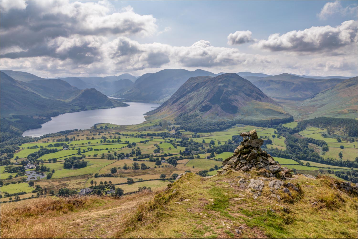
Summit cairn on the south top of Low Fell, looking towards the Loweswater Fells

The classic view from the cairn just below the south top, which brings back many happy memories of times spent here

A glimpse of Loweswater on the right

An energy sapping down and up follows to Darling Fell

The wonderful view from well named Darling Fell, looking along Crummock Water into the heart of lakeland...

...and now looking back to Low Fell, with Whiteside and Grasmoor beyond

The Irish Sea in the distance as I start the descent from Darling Fell...

Askill Knott is ahead, and before it I'll turn left to head down to Loweswater

Loweswater below, and my route will take me through Holme Wood on the far shore

I head towards Askill in order to descend to Loweswater

The head of Loweswater - the lake is unique in that it drains into lakeland (which is to the left) rather than out to the sea, which is on the right

Looking towards Fangs Brow

Burnbank Fell and Carling Knott above Loweswater

I arrive at the Loweswater road. For anyone looking to shorten the walk, the road could be followed here, but the sun continued to shine and I preferred to take the longer route around the far side of the lake

I follow the path around the head of Loweswater

Looking across to Loweswater...

...and now looking back to Darling Fell and Low Fell, where I'd been earlier

I descend to the lakeshore...


I follow the path through Holme Wood, owned and managed by the National Trust

A view across the lake to Low Fell...

...and again, as I leave Holme Wood

I follow the track away from the lake, here looking back to Carling Knott

Two road signs give rise to an internal debate. The Kirkstile Inn is temptingly close, but virtue prevails and I turn left here

The valley lane leading back to Thackthwaite

I pass by Foulsyke and Crummock Water Cottages and admire the wonderful view towards Crummock Water

Scale Hill Cottages below Brackenthwaite Hows

Further along the quiet lane

I arrive back in Thackthwaite

Just beyond the village, the view across Lorton Vale from the parking space
