
Route: Hallin Fell
Area: Far Eastern Lake District
Date of walk: 7th July 2022
Walkers: Andrew
Distance: 3.6 miles
Ascent: 1,100 feet
Weather: Sunny and very warm
This is a walk I’ve followed on several occasions and it never fails to please – there is beauty every step of the way
I parked as usual by St Peter’s Church on Martindale Hause, which gave me a good leg up today’s objective, Hallin Fell. The climb up the grassy slopes started immediately and it was very easy going – I was at the top within 20 minutes
The summit of this modest little fell has two points of interest – a wonderful view over Ullswater, and a massive 12 foot tall summit cairn out of all proportion to the height of the fell – a monument which can be seen for miles around. Having taken in the views I then descended to the shore of Ullswater down a steepish path with wonderful views of the lake ahead all the while. This brought me to the shoreline path, part of the Ullswater Way, which runs to the head of the lake. Much of the path runs through Hallinhag Wood, and the shade from the trees brought welcome relief as it was a swelteringly hot day. There are various small pebble beaches along the way which provide ideal picnic spots
After walking along the shore for 20 minutes or so I turned inland just before reaching Sandwick Bay. The junction is easily missed and lies just before a gate leading to the bay. From here I climbed up through woodland beside a dry stone wall. This joined the elevated path along Hallin Bank, with views over Ullswater and along the valleys of Boredale and Howe Grain. Bracken on this section obscured the path for much of the way but navigation was straightforward thanks to a dry stone wall on my right
Near the end of Hallin Bank I turned left to join a path above Hause Farm which brought me back to the start of a short but very sweet walk
For other walks here, visit my Find Walks page and enter the name in the ‘Search site’ box
Click on the icon below for the route map (subscribers to OS Maps can view detailed maps of the route, visualise it in aerial 3D, and download the GPX file. Non-subscribers will see a base map)

Scroll down – or click on any photo to enlarge it and you can then view as a slideshow

St Peter's Church Martindale at the start of the walk

I cross the road from the car park by the church and will return via the grassy path on the right

The gentle climb starts immediately

Looking back to St Peter's Church behind the trees

Howe Grain and Beda Fell

I pass by a prominent cairn

I continue up the grassy path

The twin valleys of Howe Grain and Boredale, separated by Beda Fell

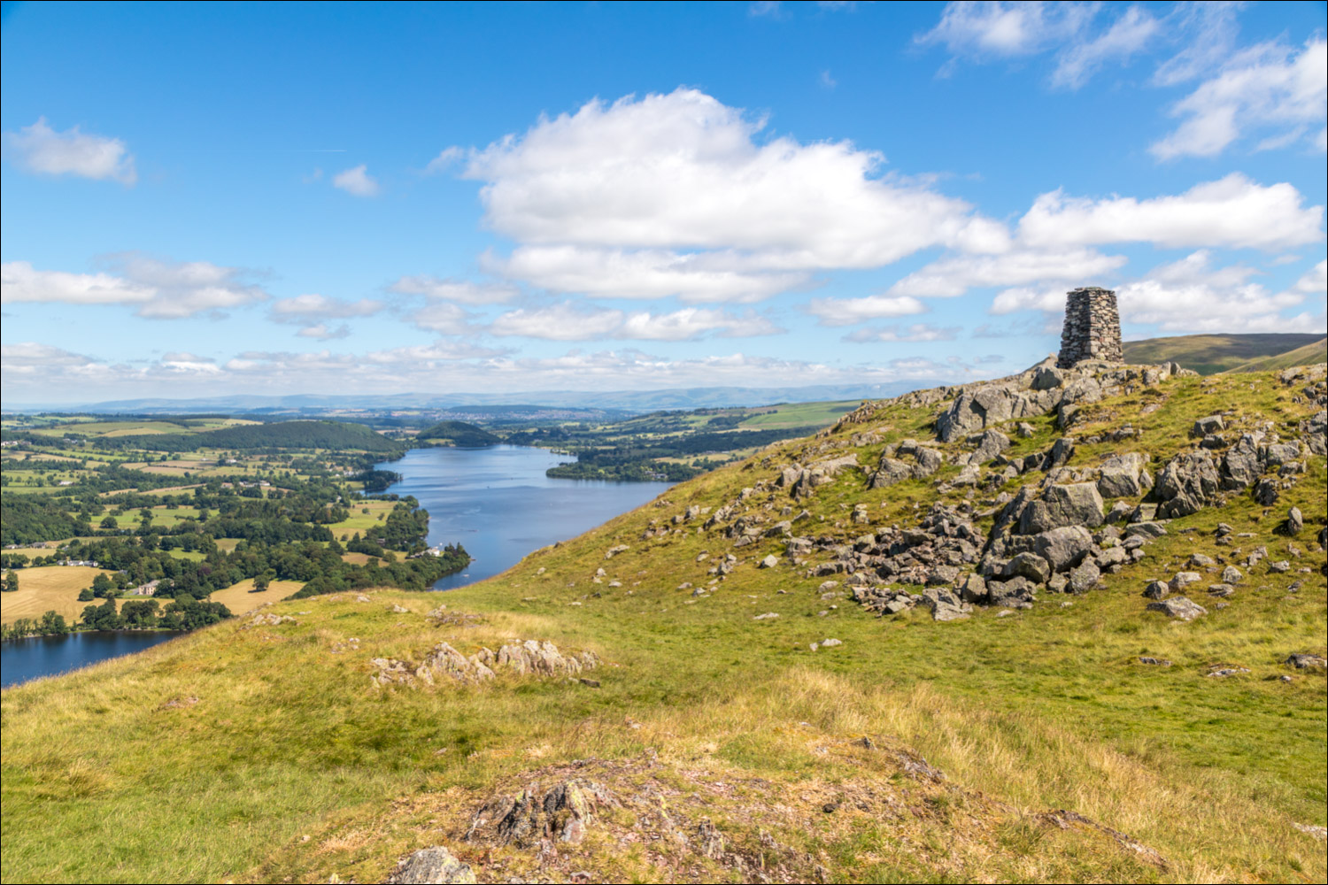
Summit of Hallin Fell, looking north along Ullswater

The massive summit cairn, dwarfing the walkers next to it

The cairn again, looking towards Ullswater

Looking towards the head of Ullswater

Another cairn marks the start of the descent

It's a wonderful descent, one of the best, with these views of Ullswater ahead all the way....


The Ullswater Steamers plying their trade around the lake

At the trees below I arrive at the shoreline path and turn left along it

I follow the path, part of the Ullswater Way, around Geordie's Crag...


Looking back to the foot of Ullswater

Skelly Neb on the far side of the lake

Kailpot Crag ahead, and beyond it I enter into Hallinhag Wood

Near Sandwick Bay I leave the shoreline path here, and turn left uphill - the junction is easily missed

I follow a path uphill through the woods, with a dry stone wall on my right

I emerge from the woods onto open fellside. The path is quite faint, especially at this time of year when the bracken is high

A dry stone wall on the right assists navigation. Beda Fell is ahead

Looking along Howe Grain

A view back to Ullswater

Howe Grain again

The end of the walk is ahead, the highlight of which was the views of Ullswater on the descent from Hallin Fell....
The following day, a magical dawn over the head of Buttermere…
