
Route: Nether Wasdale
Area: Southern Lake District
Date of walk: 1st July 2022
Walkers: Andrew
Distance: 4.8 miles
Ascent: 300 feet
Weather: Cloudy with a few patches of sun
Wasdale is home to England’s highest mountain and its deepest lake. The head of the valley is a springboard to some of the finest fell walks in the Lake District. However the fells enclose the valley head to such an extent that low level walking opportunities there are very limited. Nether Wasdale, at the foot of Wastwater, is a better choice for a low level walk, and offers wonderful views towards some of the finest landscape in the country
I’ve followed this walk, or variations of it, on several occasions and parked as usual in the car park at Cinderdale Bridge, at a triangle of roads just beyond Nether Wasdale. After turning right out of the car park I crossed the River Irt, and then joined the track leading to Easthwaite Farm. Beyond the farm, confusion may arise when a path to Lund Bridge, clearly marked on the OS maps as a public footpath, bears a sign ‘PRIVATE – no public right of way’. Either the OS map is wrong or the landowner has created a diversion in order to keep walkers away from his field. It’s not an issue, as the extra distance is not significant and the surrounding scenery is so good
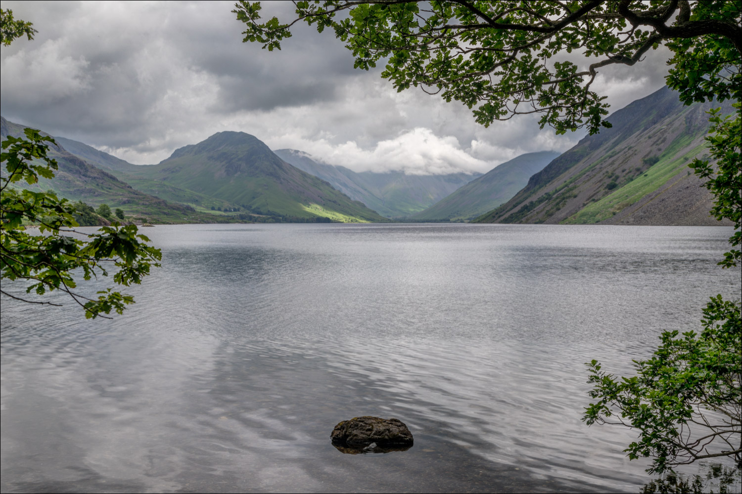
I joined the path beside the River Irt and crossed Lund Bridge to enter into Low Wood, a good place to see bluebells in season. I followed a path through Low Wood and arrived at the foot of Wastwater. The view from here is one of the finest mountain landscapes in the Lake District, but was not seen at its best today, with low cloud obscuring the tops of the higher fells
I continued along the lakeshore path and just beyond Wasdale Hall climbed up to the road which I followed for a short distance before turning off at High Birkhow. The track beside the wood, and through the open countryside at Ashness How, is always a boggy affair and today was no exception. There are many good retrospective views to Wasdale Head along the way. I left the path to cross Scale Bridge and then followed the pleasant path through Mill Place back to the start of the walk
For other walks here, visit my Find Walks page and enter the name in the ‘Search site’ box
Click on the icon below for the route map (subscribers to OS Maps can view detailed maps of the route, visualise it in aerial 3D, and download the GPX file. Non-subscribers will see a base map)

An early morning visit to Crummock Water the day before the walk…

The start of the walk as I follow the track to Easthwaite

Irton Fell ahead

The Wastwater Screes which plunge into Wastwater, unseen from here

Looking across to Low Wood, which I'll pass through shortly, with Wasdale Head beyond

A track on the left passes around Easthwaite Farm

Beyond the farm I continue along the track in the direction of Wastwater

Middle Fell and Yewbarrow

Yewbarrow at the head of Wastwater

The path on the left is shown as a public footpath on the OS map, but is marked 'Private'. It's no hardship to take the alternative route and continue along the track

The head of Wastwater is beyond the gate, but I turn left here and enter into Low Wood

The River Irt on my right as I walk through the wood....


Lund Bridge ahead

Lund Bridge, an ancient packhorse bridge

I cross over the bridge and turn right

I follow a path beside the other bank of the River Irt

Boathouse at the point where the River Irt flows out of the foot of Wastwater


The start of a heavenly section as the path reaches the shore of Wastwater...


Middle Fell and Yewbarrow through a gap in the trees

The light had deteriorated by now, but the classic view to the head of Wastwater was still a wonderful sight

Yewbarrow again

Beyond the foot of the lake, I continue along the shoreline path for a short distance

Looking across to the Wastwater Screes

I arrive at the road to Wasdale Head and turn left here to start the return leg

After a short road section I join a path across Ashness How, with Buckbarrow on my right

Ashness How

Buckbarrow

Looking back to Middle Fell

I cross an old bridge near Mill Place

Looking back to Buckbarrow

The end of the walk as I arrive back at Cinderdale Bridge
