
Route: Crummock Water
Area: Western Lake District
Date of walk: 9th July 2022
Walkers: Andrew
Distance: 2.1 miles
Ascent: 400 feet
Weather: Mostly sunny
Crummock Water is often overlooked thanks to the proximity of its sister lake, Buttermere. However it’s equally beautiful, far quieter and provides more varied walking opportunities. One of these is the approach via Lanthwaite Hill, also known as Brackenthwaite Hows, one of my favourite places in the Lake District. This walk has featured on my site many times, but I take the view that no two walks are ever the same – changing seasons and variations in the light and weather make for an infinite number of possibilities – and there’s always something new to be seen. This is only a short walk, but in the space of 2 miles manages to cram in a wide variety of scenery, all of it beautiful
I parked as usual in the National Trust car park at Scale Hill. Instead of taking the obvious track ahead, which leads directly to the north shore of Crummock Water, I turned left up a narrow path through Lanthwaite Wood. At a junction I turned left again to continue uphill, climbing a steep rocky staircase along the way
After leaving the woods via a deer gate I was soon at the top of the hill, admiring the superb views over Lorton Vale, Loweswater and Crummock Water. I then followed the easy path back down into Lanthwaite Wood, following a path which hugs the edge of the woods, giving good views across to Lanthwaite Green and Grasmoor
The path descends to the eastern shore of Crummock Water, and when I arrived at the lakeshore I followed the path to the foot of the lake, from where there are more good views towards Mellbreak and Rannerdale Knotts. From this point there are two ways back to the start – a path which follows the bank of the River Cocker, and the wide track leading through Lanthwaite Wood (the latter is shown on the route map). Today I walked back along the riverbank path to end a walk which never fails to delight
For other walks here, visit my Find Walks page and enter the name in the ‘Search site’ box
Click on the icon below for the route map (subscribers to OS Maps can view detailed maps of the route, visualise it in aerial 3D, and download the GPX file. Non-subscribers will see a base map)

Scroll down – or click on any photo to enlarge it and you can then view as a slideshow

From the Scale Hill car park I turn steeply uphill and turn left at this junction to continue the short climb

One of three rocky sections on the way up

I pass through this deer gate to enter onto Lanthwaite Hill, also known as Brackenthwaite Hows

From the top of the hill, looking north along Lorton Vale...

...and now looking west towards the Loweswater fells...


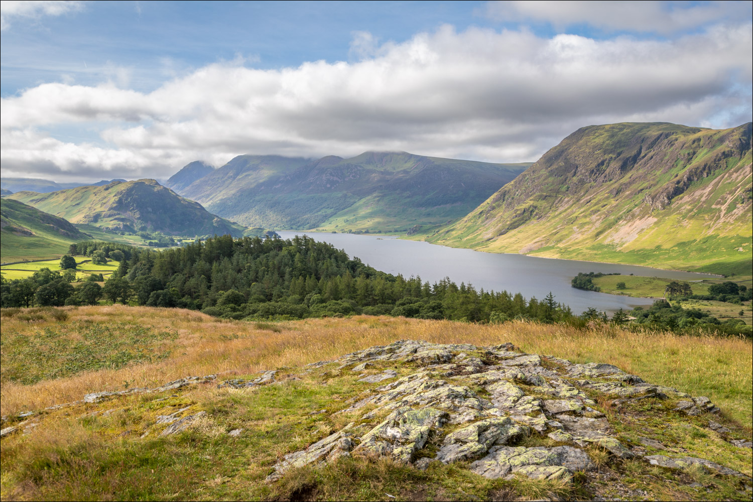
Crummock Water from the top of Lanthwaite Hill

Lanthwaite Green and Rannerdale Knotts

Mellbreak, and a 360 degree panorama of the view from here....

Whiteside

Back to the start of a wonderful short walk

There's an obvious track leading back to the start, but today I decided to follow a parallel path beside the River Cocker

Mellbreak again

After following the lakeshore path I arrive at the foot of Crummock Water

Looking across to Mellbreak from a stony beach by the boathouse

Boathouse on the shore of Crummock Water


I turn left and gradually descend to Crummock Water...

I descend gently downhill in the direction of Crummock Water

The foot of Grasmoor through a gap in the trees


There are various paths in Lanthwaite Wood, but no possibility of going astray if you keep to the edge of the wood


I re-enter Lanthwaite Wood...
