
Route: Great Crag
Area: Central Lake District
Date of walk: 5th August 2022
Walkers: Andrew and Gilly
Distance: 5.6 miles
Ascent: 1,400 feet
Weather: Mixed cloud and sunshine, with a few light showers
Great Crag is a mid-level lakeland fell which I visited this time last year, when it was covered with a coat of purple heather. Hoping for more of the same, we decided to revisit the fell
We parked just outside the small hamlet of Stonethwaite, where there are several parking spaces . We crossed the nearby beck via Stonethwaite Bridge, turning right immediately to join the Cumbria Way for a short distance. We then left the Cumbria Way to join a path heading uphill. This is easily missed – look out for an old sheepfold at the junction. It was a steep climb, but the addition of rock steps made the ascent a straightforward affair and before long we arrived at Dock Tarn. The tarn is surrounded by numerous mounds and tors, all covered with heather, and it’s a lovely sight. In the words of Alfred Wainwright, ‘Dock Tarn is a place to lie adreaming, and life seems a sweet sweet thing’
Great Crag is a complicated place, full of ups and downs, and determining the summit and the path to it is not a simple affair. There are numerous small paths, some of which peter out. We simply aimed for the highest point and, after some meandering, arrived there. Another top with a slightly larger cairn was nearby, so we visited that too. Both are wonderful spots
We descended to rejoin the main path below and headed in the direction of Watendlath and its tarn. The path took us across some wild and very juicy terrain leading to Puddingstone Bank. From here the path descended alongside Bowdergate Gill, with wonderful views into Borrowdale, before merging with the Cumbria Way lower down. From here it was a short stroll beside Stonethwaite Beck back into Stonethwaite, and the end of a superb walk
For other walks here, visit my Find Walks page and enter the name in the ‘Search site’ box
Click on the icon below for the route map (subscribers to OS Maps can view detailed maps of the route, visualise it in aerial 3D, and download the GPX file. Non-subscribers will see a base map)

Scroll down – or click on any photo to enlarge it and you can then view as a slideshow

The start of the walk from the hamlet of Stonethwaite

We cross Stonethwaite Bridge and turn right to join the Cumbria Way

After following the Cumbria Way for a short distance we turn uphill at this sheepfold

Crags below Rosthwaite Fell

Looking back to Stonethwaite

We cross this stile in the wall

A stone staircase during the early part of the ascent

The Honister Pass and Fleetwith Pike

We pass by another old sheepfold

Looking back to Rosthwaite Fell

Waterfalls in Willygrass Gill, which flows out of Dock Tarn

Eagle Crag and Sergeant's Crag

We cross this stile, here looking back to Eagle Crag and Sergeant's Crag, with Langstrath on the right...

...and now looking back to Rosthwaite Fell...


The path is never far from Willygrass Gill, which is a reliable guide if doubts arise


We arrive at Dock Tarn, a heavenly spot, and walk along its western side


Beyond the tarn we seek out the nearby summit of Great Crag, which is attained by turning left off the main path


There are two summits on the fell - this one is about 10 feet lower than the other

Looking down to Watendlath and its tarn

The other summit of Great Crag

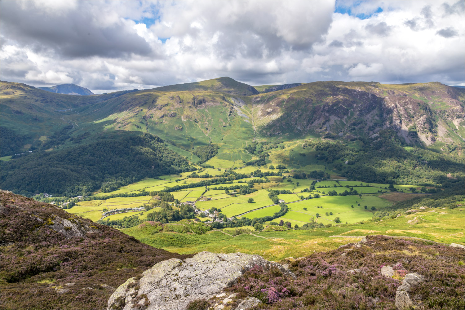
Looking down into Borrowdale

The start of the descent

Lovely views of Watendlath Tarn as we make our way down...


We follow a faint path over some boggy and remote terrain. Grange Fell is ahead, and we'll turn left at its foot

Eventually we arrive at Puddingstone Bank, and pass through two gates to turn towards Borrowdale

The start of a heavenly descent, with views over Borrowdale all the way down...


We arrive back at valley level

Our path meets up with the Cumbria Way at this point and we turn left at the dry stone wall

Rosthwaite Fell ahead


The imposing face of Eagle Crag at the head of the valley...


We leave the Cumbria Way and turn sharp right into nearby Stonethwaite

We re-cross Stonethwaite Bridge and the end of the walk is just around the corner
