
Route: Grasmoor, Wandope and Whiteless Pike
Area: North Western Lake District
Date of walk: 28th May 2019
Walkers: Andrew and Gilly
Distance: 7.1 miles
Ascent: 2,900 feet
Weather: Mixed sunshine and cloud, with a shower half way through
We parked in the small car park at Cinderdale Common, from where the climb up the Lad Hows ridge starts immediately. There is no respite from the ascent, though it’s fairly easy going until the last steepish section to the summit of Grasmoor, which seems to go on forever
The views from the summit of Grasmoor were superb, and we could clearly see across the Solway Firth into Scotland looking north, and many of lakeland’s finest fells, including the Scafells, looking south
We retraced our steps from the summit for a short distance and then descended to Wandope Moss, stopping to chat briefly to some volunteers from Fix the Fells who were were hard at work repairing a drainage channel. Without their efforts, some of these paths would unpassable. After thanking them for their sterling work we made the easy ascent of Wandope. Although this constitutes a diversion from the path to Whiteless Pike, it’s only a 5 minute one. Despite that, it wasn’t really worth the effort today as the weather suddenly closed in, with a passing rain shower borne on a bitingly cold wind from the north
From Wandope we descended to Whiteless Edge, enjoying some wonderful views of the surrounding fells along the way, before the last ascent of the day to the top of Whiteless Pike
We then descended, quite steeply at times, to the junction at the head of Rannerdale. Having turned sharp right here it was an easy walk down High Rannerdale back to the start. The famous bluebells had by now gone over, but to see photos of this spectacle in one of my recent walks, click here. At the end of Rannerdale it was a simple short stroll back to Cinderdale Common
Apart from the shower half way through, the weather was perfect for fellwalking today – good visibility, sunshine and clouds and a cooling breeze on the tops helped to make this a special day
For other walks here, visit my Find Walks page and enter the name in the ‘Search site’ box
Click on the icon below for the route map (subscribers to OS Maps can view detailed maps of the route, visualise it in aerial 3D, and download the GPX file. Non-subscribers will see a base map)

Scroll down – or click on any photo to enlarge it and you can then view as a slideshow

The start of today's walk, looking back over Crummock Water from Cinderdale Common

Waterfalls in Cinderdale Beck as we start the long ascent up the Lad Hows ridge...


Looking across Rannerdale Knotts to Red Pike

Grasmoor up in the clouds to the left

Looking back to Crummock Water and a glimpse of Loweswater beyond...

...and now looking back down Cinderdale Beck to Mellbreak on the far side of Crummock Water

Rannerdale Knotts and Rannerdale

Onwards and upwards - our route will take us up the ridge on the right, and we'll then turn left to enter Grasmoor via the back door

Rannerdale Knotts and the High Stile Range beyond

In order of appearance, Crummock Water, Loweswater and the Solway Firth in the far distance

The Lad Hows ridge now reveals itself, gradually curving round to the left

Rannerdale Knotts and the High Stile range again

Traffic on the road

Buttermere comes into view, with Great Gable in the background

Zooming in on Loweswater and beyond it is the Solway Firth and Scotland

Higher up the ridge the gradient steepens

Looking back

A lone hawthorn tree in Rannerdale - the path beyond it will be on our return route

Views back down the path towards Crummock Water...


Whiteless Pike on the left, and this will be part of our return route...

...Rannerdale Knotts dwarfed now by the surrounding fells

Another view back as we reach the end of the steep section

The summit of Grasmoor is just over the hill

Small cairn below the summit, with views of Buttermere and Crummock Water

The main summit cairn shelter, looking north towards the Solway Firth

The summit of Grasmoor is a large grassy plateau, and it's a 5 minute walk before I can admire the view to Skiddaw, Blencathra and Keswick

We retrace our steps for a short distance and set off along the ridge which leads to Crag Hill

Whiteless Edge and Whiteless Pike, where we'll be shortly

The crossroads at Wandope Moss below - we'll turn right there, but then angle uphill to Wandope

Fix the Fells volunteers - this drainage channel will prevent the path being washed away after heavy rain. Thanks again for all your hard work

Summit of Wandope - the weather was closing in here and we didn't linger

Whiteless Edge leading to Whiteless Pike

Rannerdale Farm below, and on the far side of Crummock Water is Low Ling Crag and High Ling Crag

Looking down to the Newlands Pass

Views back along Whiteless Edge...

...Grasmoor up on the left

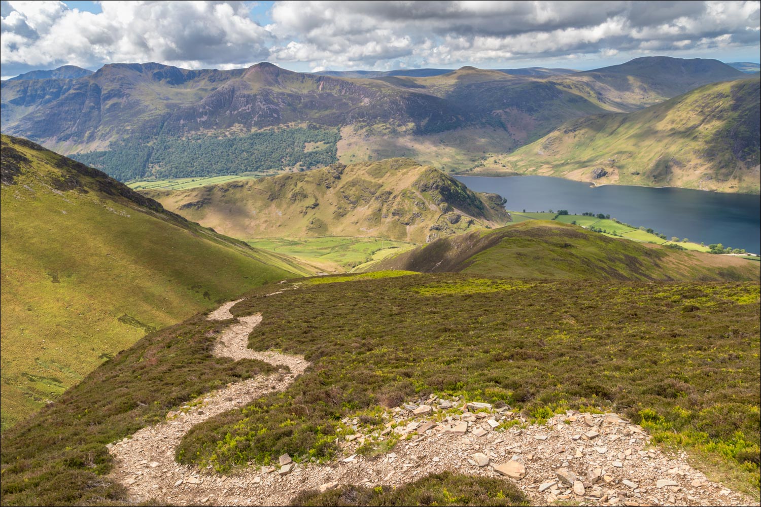
From Whiteless Pike - Crummock Water, Loweswater and the Solway Firth, with the hills of Scotland in the far distance

The Lad Hows ridge, which we'd followed earlier, is well seen from here, curving up from bottom left to top right

Buttermere village and the head of Crummock Water below

Newlands Pass below and the Scafells in the distance

Rannerdale Farm

We continue the descent from Whiteless Pike in the direction of Buttermere

An inquisitive herdy

Our return route Rannerdale below and beyond it three stretches of water - Crummock Water, Loweswater and the Solway Firth

Descending into High Rannerdale

The path turns back to face Buttermere, with Haystacks and Great Gable beyond it

Sourmilk Gill at the foot of Buttermere

Descending into Rannerdale

We follow the path by the dry stone wall, and cross the footbridge over Squat Beck


The foot of Rannerdale Knotts and Crummock Water to our right as we follow the easy path

Looking back up Rannerdale

Rannerdale Knotts and Red Pike

The end of a wonderful walk as we arrive back at Cinderdale Common, here looking towards Low Fell
