
Route: Whin Rigg and Illgill Head
Area: Southern Lake District
Date of walk: 17th August 2015
Walkers: Andrew and Gilly
Distance: 10.3 miles
Weather: Mostly sunny
We parked on the shore of Wastwater at the end of the road from Gosforth, though the walk could be started from anywhere along the lakeside. The lake was like a millpond as we started out and the initial section of the walk which took us round the foot of the lake was worth the journey in itself
But even better things were to come. Having rounded the lake and walked away from it for a while we started the ascent just before Greathall Gill – to start the climb before this point would be suicidal and as Wainwright puts it ‘this is one fellside that walkers can write off at a glance as having no access for them’. Our route avoided these horrors and took us steeply but safely up the fellside until we eventually emerged onto the summit ridge
From the summit cairn on Whin Rigg we could see the wide path along the ridge leading to Illgill Head. We took a narrower path to the left, which hugs the side of the crags more closely and gives thrilling views down the chasms and precipices which plunge into Wast Water. This was an awesome section of the walk and I’d recommend anyone walking this ridge to go the way we did, instead of following the main path which misses these incredible views
The path back down to the valley from Illgill Head was very easy, and having reached the head of the lake we returned to the start along the roadside. There’s no way of avoiding the road but this is no chore in such wonderful surroundings. Note that the OS map shows a path along the other shore along the foot of Whin Rigg and Illgill Head but take it from me it’s not a practical option – I tried it once but the massive boulders make it a nightmarish walk – never again
As we walked along the road back to the car we looked across the lake to the fearsome face of the fells, which seen from here betray no sign of the grassy stroll along the top of them. It had been a memorable walk
For other walks here, visit my Find Walks page and enter the name in the ‘Search site’ box
Click on the icon below for the route map (subscribers to OS Maps can view detailed maps of the route, visualise it in aerial 3D, and download the GPX file. Non-subscribers will see a base map)

Scroll down – or click on any photo to enlarge it and you can then view as a slideshow

Red squirrel in the garden before we set off this morning

An hour or so later, this was the glorious scene as we parked our car near the shore of Wast Water

Kirk Fell and Lingmell at the head of the lake


It was time to get on with the walk, so we turned away and walked along the road towards the foot of the lake

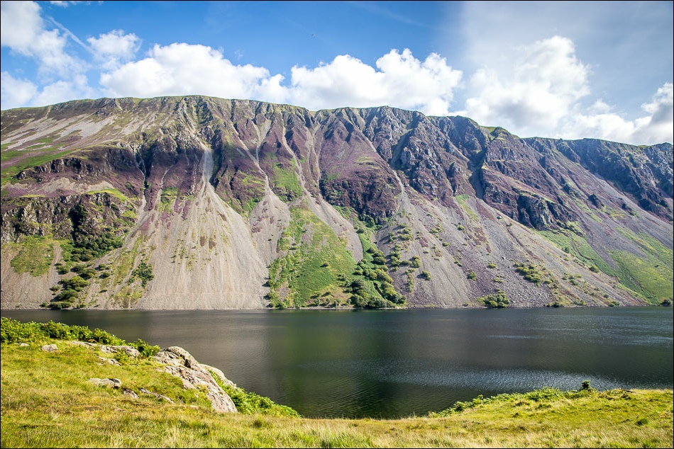
We leave the road to join a path leading into Low Wood - the Wast Water screes can be seen across the lake

The screes again on the right

Looking across Wast Water

Further along the lakeshore path


Low Wood at the foot of the lake

Entering Low Wood

Looking along the length of Wast Water

We cross Lund Bridge over the start of the River Irt

Approaching the fellside

A battle against the bracken - the start of the climb up to Whin Rigg

Yewbarrow and Wast Water as we gain height

Looking the other way, we can see the Isle of Man in the distance

After a long climb we arrive on the ridge and follow the path up to Whin Rigg

Summit of Whin Rigg, looking along the ridge to our next target - Illgill Head

We follow the narrower of the two paths, keeping as close to the edge as we dare - there are near vertical drops off to the left

Looking back to Sellafield and the Irish Sea

Looking down one of the fearsome gullies to Wasdale Hall Youth Hostel

Looking along the ridge

Wasdale Hall again

Our car is somewhere down there

Looking back to Whin Rigg, such a contrast between the flat grassy ridge and the huge drops on the right…


Yewbarrow

Summit of Illgill Head, looking towards Scafell which is showing its least dramatic side seen from here

Looking towards Wasdale Head at the start of the long but easy descent to the head of the lake


A good reason for walking the route in this direction - these views of Wasdale were ahead of us all the way down…


We pass by some ruins, shown on Wainwright’s map but not on the OS…

…and over an old stone bridge, also unnamed on the maps

Down to the head of Wast Water - we now have to walk back along the other side

There’s no path so we follow the road by the side of the lake - this is looking across to Illgill Head

Looking back towards Lingmell

The screes plunging into Wast Water


A last look up the the high point of today’s walk as we arrive back at the start
