
Route: Mellbreak
Area: Western Lake District
Date of walk: 15th August 2015
Walkers: Andrew and Gilly
Distance: 6.3 miles
Weather: Clouds and bright patches, some light rain at start
We parked in the small parking space by Church Bridge, just beyond the Kirkstile Inn, and walked towards Mellbreak along the lane. Seen from here, the fell looks like a pyramid and the north face appears quite formidable. This was to be the 11th time we’ve climbed Mellbreak, and we’ve always followed the same route – from north to south (so as to keep the best views in front) and then back along the shore of Crummock Water
After leaving the lane and climbing up the initial grassy slopes, we came to the scree section and from this point onwards the going was very steep and laborious but there were no real difficulties
We emerged panting at the north top and then made the easy but very squelchy walk to the south top ¾ mile away. The views from there were superb
We descended in the direction of Scale Force and as we neared the shore of Crummock Water we had a chance encounter with some fellow walkers – an amazing coincidence, about which more later
After walking along the shore of the lake, with Mellbreak towering above us, we walked past Highpark and Lowpark and thanks to some good planning were able to celebrate the end of a great walk at the famous Kirkstile Inn
For other walks here, visit my Find Walks page and enter the name in the ‘Search site’ box
Click on the icon below for the route map (subscribers to OS Maps can view detailed maps of the route, visualise it in aerial 3D, and download the GPX file. Non-subscribers will see a base map)

Scroll down – or click on any photo to enlarge it and you can then view as a slideshow

Nuthatch in the garden before we set off this morning…

and a red squirrel


Mellbreak from Lorton Vale - the north top, the dip in the middle and the south top at the far end

After a 5 minute drive we park by Church Bridge - this is looking back to the Kirkstile Inn

We set off down the lane towards Mellbreak - its ridge and south top are out of sight

The north face of Mellbreak - not quite the north face of the Eiger, but it looks quite steep seen from here

Beyond Kirkgate Farm the lane turns into a stony track

Crummock Water comes into view

Further along the track

Flass Wood at the foot of Mellbreak

We leave the track at this point to climb up a firebreak in the woods

Looking back down the nursery slopes of Mellbreak to Loweswater

The Kirkstile Inn and Loweswater Church centre picture, Low Fell beyond and sweet Lorton Vale on the right

Looking down our path, which has by now become loose scree

Grasmoor on the far side of Crummock Water

Bonnie

Heather in bloom - a lovely sight as we gained height

‘A peep around the corner’ - Crummock Water and Buttermere beyond

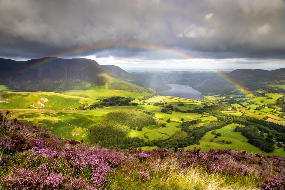
Looking back over the heather to Loweswater, and the Solway Firth and Scotland in the distance

Looking back down the promontory we’d just ascended

It started to rain here - but there was a bonus in the form of this rainbow


North top of Mellbreak

Lorton Vale from the north top

Looking along the flat ridge to the south top

Buttermere from the south top of Mellbreak

Fabulous views of Crummock Water and Buttermere as we start the descent - illustrating why this walk is best done north to south


Lonely Mosedale

Scale Force between the trees

We round the corner to head down to the shore of Crummock Water - notice the two walkers further along the path…

…I don’t believe it! Kath and Mark, who we’d met on a walk in Austria 5 weeks ago. Hope to see you again someday, somewhere…

We carry on down to the lakeshore

Looking back towards Fleetwith Pike

Low Ling Crag looking towards Grasmoor, Whiteless Pike and Rannerdale Knotts

Further along the lakeshore path

Looking back along the path to Rannerdale Knotts

We climb above the lake to head back to the start - here looking towards Whiteside and Grasmoor

We walk along the foot of Mellbreak

Crossing Park Bridge, we now follow the lane beside Park Beck

A sight to gladden the heart of a weary walker - the Kirkstile Inn

The pot of gold at the end of today’s rainbow
