
Route: Stackpole Estate
Area: Wales, Pembrokeshire
Date of walk: 10th September 2019
Walkers: Andrew and Gilly
Distance: 5.8 miles
Ascent: 500 feet
Weather: Perfect
The Stackpole Estate has a long history. The earliest building here was a Norman Castle built by Elidur de Stackpole in the 11th century. The estate then passed down the generations by descent or marriage until it was broken up in 1970 and the coastal park given to the National Trust. The present 2,000 acre estate has a wonderful array of habitats, including a rugged stretch of coastline, beaches and coves, dunes, woodland and fields. In addition to all this there are the famous Bosherston Lily Ponds, a haven for wildlife. This makes it a perfect place for walking
A mediocre weather forecast proved to be completely inaccurate, and on a day of sun and blue skies we arrived early at the National Trust car park at Stackpole Quay. From here we joined the nearby Wales Coast Path, which we’d follow for much of the way. After an easy climb we were soon on the clifftops enjoying some spectacular views. After a short distance we descended to Barafundle Bay, regularly voted as one of Wales’ most beautiful beaches, and it’s not hard to see why. It’s an idyllic spot and we had the place to ourselves thanks to an early start, and the fact that the beach cannot be accessed save by a 15 minute walk
At the far end of the beach we climbed up onto the clifftops again. There are several informal paths that have sprung up nearer to the edge than the main one, and we followed these when we could, as they offered more extensive views. It was a superb section of the walk, enhanced by the lovely weather. Eventually we arrived at another pristine sandy beach, Broad Haven South, and this marked the point where we turned inland. Our path took us alongside the Lily Ponds, where we had some good wildlife sightings. We left the ponds by crossing over Eight Arch Bridge, and walked back to the start through rolling countryside. It had been a superb walk, one of the very best, and the only disappointment was having to end it
Click on the icon below for the route map (subscribers to OS Maps can view detailed maps of the route, visualise it in aerial 3D, and download the GPX file. Non-subscribers will see a base map)

Scroll down – or click on any photo to enlarge it and you can then view as a slideshow

The start of the walk as we leave the National Trust car park at Stackpole Quay and join the Wales Coast Path

Looking back along our path

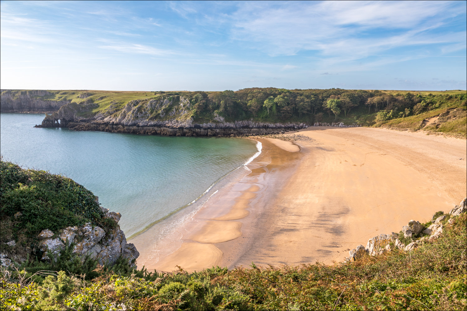
Barafundle Bay comes into view

The bay was owned by the Cawdor family of Stackpole Court, and it was their private beach

We pass through this arch and descend the steps, which were added by the Cawdors to ease access to their beach

We stroll along the deserted beach, a heavenly place...


A final view of Barafundle Bay as we rejoin the Wales Coast Path

We follow a path beside the cliffs

Looking back to the natural arches encircling Barafundle Bay...


We walk out onto Stackpole Head


We continue to follow the Wales Coast Path

We head for another rocky promontory, Mowingword


A small detour to the tip of Mowingword

Mowingword Bay, the most spectacular beach in Wales, but also one of the hardest to access, requiring either a boat, abseiling equipment, or a lengthy swim from Box Bay further along the coast

None of these possible means of access were feasible for us, and we contented ourselves with walking around the edge of the cove...


Pinnacle Stack in the centre of the bay

A deep blow hole - how deep I can't say, as I didn't dare venture closer than this - but there is one in the vicinity which reaches to the beach floor

Unlike many cliff top walks, there are very few ups and downs and we are walking mostly on the level

Church Rock in the distance, marking the point where we'll head inland

Raming Hole, which connects with Mowingword beach at low spring tides

Box Bay, another beach which may only be accessed by climbing down - ropes are recommended. Church Rock is on the left

We walk round the edge of Box Bay...


We arrive at the adjoining beach of Broad Haven South, marking the end of the coastal section of the walk

We descend to the beach...


We leave the beach via this bridge and follow a path to the adjacent Bosherston Lily Ponds

The Cawdors built Bosherston Lily Ponds, or Bosherston Lakes, between 1780 and 1860 as the focal point of their designed landscape

The lakes are supplied by springs fed by a natural underground reservoir, and the water escapes the same way during dry spells

Nesting swan and cygnets

Another family of swans, with 8 cygnets

Heron. We had hoped to see an otter here but our luck was out

Eight Arch Bridge ahead, which is Grade II Listed

We cross the bridge, which was built in 1797 to connect Stackpole Court to Stackpole Quay

A final look along the Eastern Arm of the lily ponds

We follow this track towards nearby Stackpole Quay, the only section of the route when we're not walking beside water

We arrive back at Stackpole Quay and the end of another wonderful walk on the Pembrokeshire coast
Follow the link for more walks in Wales (17)
