
Route: Tenby
Area: Wales, Pembrokeshire
Date of walk: 9th September 2019
Walkers: Andrew and Gilly
Distance: 7.9 miles
Ascent: 450 feet
Weather: Mostly cloudy, with some bright spells and a couple of light showers
The coastal town of Tenby is well preserved and has avoided the over development which has spoilt many other seaside resorts. Its old town and harbour are well worth a visit in their own right
We parked in the public car park next to the tourist information office and walked through the old town towards the sea. After descending some steps we arrived on South Beach and set off along the sands, aiming for the distant rock outcrop of Giltar Point
After a very pleasant stroll we arrived at the end of the beach and followed a stepped path onto the headland. It’s not necessary to visit the extreme tip of Giltar Point but we decided to do so – this involved some clambering and minor exposure at one point. We then retraced our steps back to the main path, part of the Wales Coast Path
There followed a delightful section of the walk as we followed the cliff top path heading west, with the sea on our left and an MOD firing range on our right. Take care not to depart from the path, if you veer too far to the left you will be dashed on the rocks and if you stray to the right you may become target practice
We managed to survive and at the end of the range we turned back in the direction of Tenby and descended to the road, passing under a railway bridge along the way. This section of the walk was not scenically pleasing, and we were glad to turn off at the village of Penally and return to South Beach via the local golf course, where there is a risk of being struck by an errant golf ball. We then walked back into Tenby, retracing our steps along the beach (the exact route here depends on tide times, but there’s plenty of room, even at high tide, and the risk of being cut off and drowned need not be added to the other perils of the walk)
There remained time for a stroll around the picturesque old town and its harbour to round off another superb walk on the Pembrokeshire coast
Click on the icon below for the route map (subscribers to OS Maps can view detailed maps of the route, visualise it in aerial 3D, and download the GPX file. Non-subscribers will see a base map)

Scroll down – or click on any photo to enlarge it and you can then view as a slideshow

The start of the walk as we pass by the walls of the old town of Tenby

Looking across to St Catherine's Island and Fort St Catherine as we descend the steps to South Beach

Looking back up to Tenby

South Beach - we follow the Wales Coast Path along the beach, although the precise route depends upon tide times

Looking back to Tenby and St Catherine's Island

We arrive at the end of the beach

We follow this path which takes us to the top of the sand dunes...


Looking back along South Beach to Tenby

We arrive at the top of the dunes

Penally, which we'll pass through later

Giltar Point - not knowing what to expect, we decided to climb to the highest point. There was some exposure to a sharp drop on the left but we survived to tell the tale

Caldey Island, one of Britain's holy islands, which is home to a monastery of Cistercian monks

Giltar Point

After descending from the point (trickier than ascending it), we start the cliff top walk heading west along the Pembrokeshire Coast Path...


Looking back to Giltar Point...


Zooming in to Tenby on our right

It's an easy stroll along a grassy plateau, although shortcuts can't be made here as there's an army rifle range on the right

At the end of the range we descend towards Penally

Penally

We cross under the railway line and follow the road through Penally (a scenically less attractive section of the walk and hence no photos)

The local golf course provides a route back to the beach, if you manage to avoid being felled by a stray golf ball

We arrive back on South Beach

We head back towards Tenby...


A turnstone on the sands

St Catherine's Island comes back into view

Tenby and its attractively painted houses...


The tide permits us to continue along the beach - at high tide it may be necessary to walk inland

Looking out to sea

Stone steps carved into the rocks

We arrive at the end of South Beach and climb back up into the town

The spire of St Mary's Church

We follow the footpath past the painted houses above North Beach

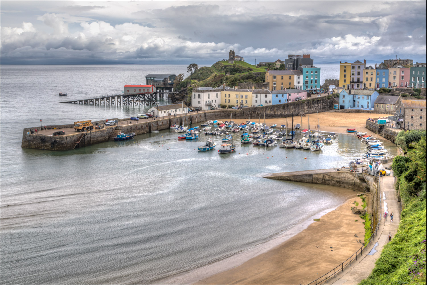
Tenby Harbour


Looking back to North Beach and Tenby Harbour

North Beach

Tenby Harbour again

The tiny harbour side church of St Julian’s at the end of our walk, and from here we head back to the car park

St Catherine's Island
Follow the link for more walks in Wales (17)
