
Route: Merbach Hill
Area: Herefordshire
Date of walk: 26th July 2022
Walkers: Andrew and Gilly
Distance: 4.3 miles
Ascent: 400 feet
Weather: Mixed cloud and sunshine
Merbach Hill is the culmination of a long ridge which separates the Golden Valley from the Wye Valley, and is one of the best viewpoints in the region. We started today’s walk from a car park adjacent to Arthur’s Stone, which is the remains of a burial chamber dating back to the neolithic era over 5,000 years ago. The site was a hive of activity today. A new excavation by a large team of archaeologists was in progress, and a BBC film crew were in attendance, filming the works for the TV series ‘Digging for Britain’. This meant that we couldn’t inspect the site closely but no matter, we’d have a chance to do so at the end of the walk
We set off on the walk following a long undulating lane, part of the long distance Herefordshire Trail. The crowds were soon behind us and from this point we only saw two other walkers during the entire route
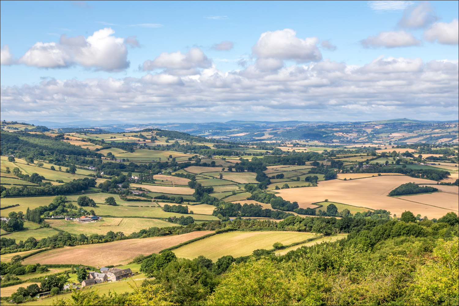
Eventually the lane swung left and we continued ahead to reach the top of Merbach Hill. The views were superb and we were fortunate that the light, which had been indifferent up to this point, gradually improved. We spent 30 minutes or so here. Vast areas of the countryside may be seen from the hill: Hergest Ridge and Radnor Forest to the north, the Black Mountains and Brecon Beacons south west, the Vale of Usk, the line of the Cotswolds and Monmouthshire south east – and more besides. Reluctantly we left the viewpoint and visited the nearby OS trig point. The view from here is slightly obscured by vegetation. We descended through thick bracken and emerged from it above Woolla Farm. There were more wonderful views from here, especially those over the meanders in the River Wye below
We continued through a mixture of pasture, apple orchards, cornfields and quiet country lanes and eventually arrived back at Arthur’s Stone Lane. From here we retraced our steps back to the start of a five star walk
Click on the icon below for the route map (subscribers to OS Maps can view detailed maps of the route, visualise it in aerial 3D, and download the GPX file. Non-subscribers will see a base map)

Scroll down – or click on any photo to enlarge it and you can then view as a slideshow

The walk starts from Arthur's Stone, situated on a long ridge which divides the Golden Valley from the Wye Valley, here looking over the former towards the Black Mountains

Arthur's Stone - it was a crowd scene when we arrived. The BBC was filming an episode of Digging for Britain, and an excavations by a large team of archaeologists were taking place. We'd return here later when it was quieter

We set off along Arthur's Stone Lane, part of the Herefordshire Trail

At a bend in the lane we continue ahead

The ridge of Merbach Hill

The weather is a little dull, but will improve shortly

Views on our left and a taste of things to come

Windswept trees along the ridge

When we reached the top of Merbach Hill the weather was showing signs of improvement so we lingered for a while, and our patience was rewarded....

Panorama from Merbach Hill looking into Wales


We visit the nearby triangulation point

We head east, following a faint path through thick bracken

It's a relief to emerge from the bracken into open countryside

More wonderful views appear on our left, this time over the Wye Valley

We follow a path towards Woolla Farm

Ever improving views over the Wye Valley as we descend....


A closer view of a large loop in the River Wye

The Malvern Hills in the distance

Woolla Farm below. We branch off to the right just before the gate

We follow another track towards Benfield Farm

We walk past some stately oak trees in Benfield Park...


We pass through a recently planted apple orchard

We arrive at Arthur's Stone Lane, which we follow for a short distance

We leave the lane here

We walk through this cornfield to arrive back at Arthur's Stone

Arthur's Stone, over 5,000 years old and with a capstone weighing more than 25 tons

A wonderful way to end the walk, the scenic highlight of which was the view from the top of Merbach Hill....
Follow the link for more walks in Herefordshire (6)
