
Route: Low Fell
Area: Western Lake District
Date of walk: 17th June 2021
Walkers: Andrew and Gilly
Distance: 4.5 miles
Ascent: 1,500 feet
Weather: Sunny
There was only time for a short fell walk today, and we could think of no better destination than Low Fell, one of our favourite places and the fell which I chose for my 1,000th Wainwright ascent in May 2018.
We were fortunate to find room in one of the few roadside spaces outside the small settlement of Thackthwaite on the west side of Lorton Vale. We walked into the village and turned right at a signpost between the houses, following a rocky lane uphill. This leads out onto the fields and from here we followed a line of old oak trees up to the intake wall. There are lovely retrospective views from here.
On reaching the intake wall we turned right to follow a grassy path which curves around the fellside into a small raised valley, where the views are lost – this is a rather dreary section in truth, but it’s soon over and before long we were on the ridge line, heading south with ever improving views along the way
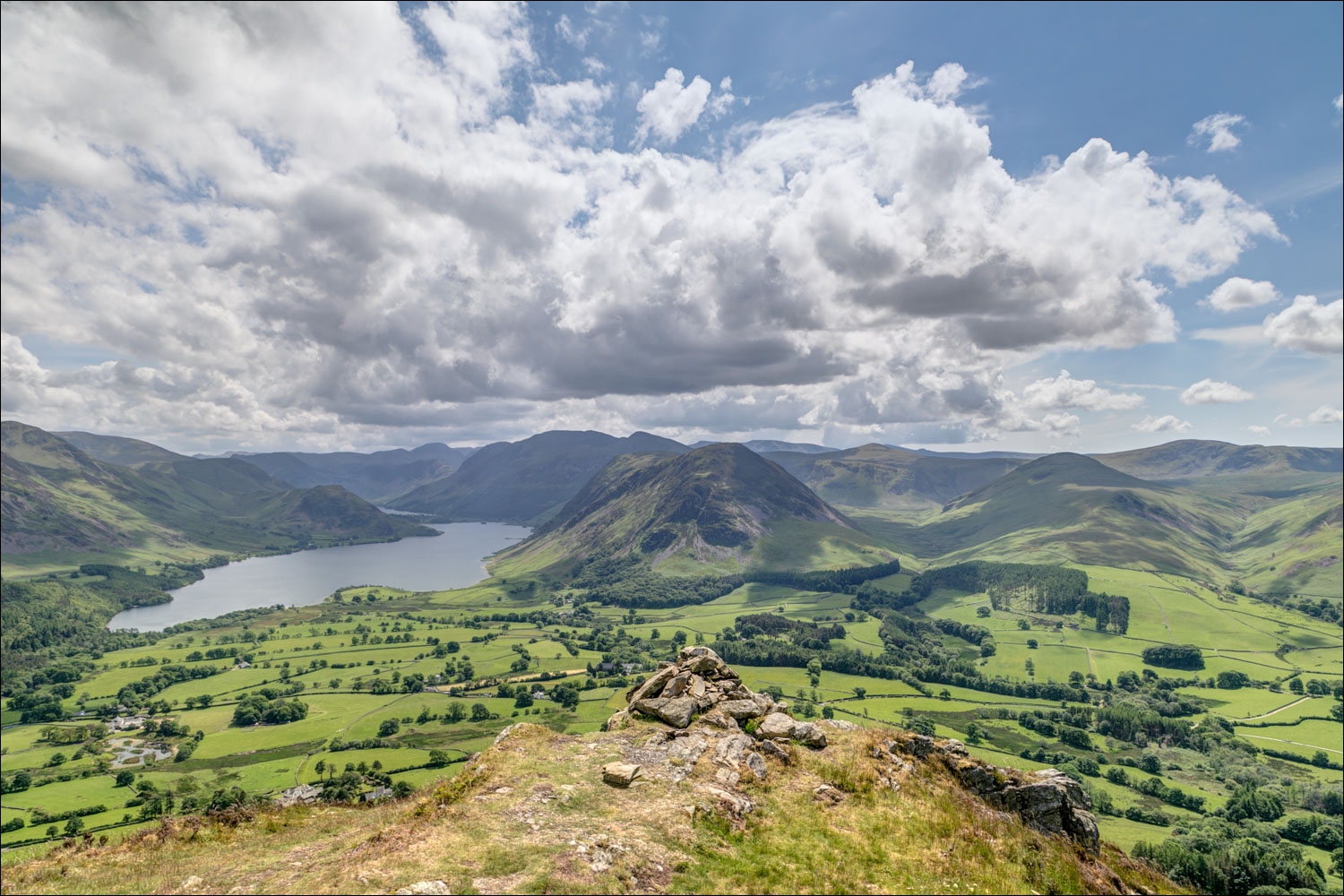
Anyone visiting Low Fell for the first time should not stop at the north top, but should continue to the very end of the ridge where there is a cairn just below the south top. From here, in the words of Alfred Wainwright, ‘the view is of classical beauty, an inspired and inspiring vision of loveliness…a scene of lakes and mountains arranged to perfection’. It was a wonderful sight and exactly as described by the master fellwalker
The only defect in routes up Low Fell is that there are no satisfactory routes off it if there’s only time for a short circular walk. It is possible to descend from the top directly into Lorton Vale, but it’s a horribly steep route and not to be recommended, and so we simply retraced our steps back to the start, which was no hardship on a day such as this
For other walks here, visit my Find Walks page and enter the name in the ‘Search site’ box
Click on the icon below for the route map (subscribers to OS Maps can view detailed maps of the route, visualise it in aerial 3D, and download the GPX file. Non-subscribers will see a base map)

Scroll down – or click on any photo to enlarge it and you can then view as a slideshow

Earlier in the week, a red squirrel in the garden...

...and a pair of endangered spotted flycatchers busy collecting flies to bring back to their nest above the front door. I spotted four gaping beaks

A view of the long ridge of Low Fell from the other side of Lorton Vale

The start of the walk from near Thackthwaite looking back across the valley to Ladyside Pike

We walk through Thackthwaite and turn right uphill beyond the wooden fence

The Low Fell ridge ahead as we follow a line of old oak trees...


Looking back to Hopegill Head and Whiteside

We'll follow a path on the right by the dry stone wall

A glimpse of Crummock Water on our left

Hatteringill on our right

A view back to Lorton Dodd and Ladyside Pike

Looking back to Crummock Water

Lorton Vale and Lorton

Fellbarrow on our right

Views back to Lorton Vale and Lorton as we gain height...


We gain the ridge, which runs from north to south

Lanthwaite Green at the foot of Grasmoor

Further along the undulating ridge

Looking across over Lorton Vale

Crummock Water

Lorton Vale again

Looking back along our path

The summit cairn on the north top comes into view

North top of Low Fell, looking across the coastal plain, with the Solway Firth just visible in the far distance

A view back towards Lorton

We continue along the ridge with ever improving views over Crummock Water

Cairn at the south top of Low Fell, but for the best view it's necessary to carry on for a few yards...

...to this heavenly spot, with a view of Crummock Water and too many fells to list


Loweswater and Holme Wood

Lorton Vale - from here we retrace our steps, no hardship on a day such as this

On the way down, we spotted the rare and endangered Marsh Fritillary butterfly - a grabbed shot and out of focus but better than nothing

Heading home at the end of a wonderful walk
