
Route: Latrigg
Area: Northern Lake District
Date of walk: 6th December 2023
Walkers: Andrew and Gilly
Distance: 5.3 miles
Ascent: 1,000 feet
Weather: Sunny, very cold
Latrigg sits at the foot of Skiddaw. Its elevation is a modest 1,203 feet, but it punches well above its height in terms of the views from the summit. These are superior (in my opinion) to those from Skiddaw, which towers up behind it and is nearly 2,000 feet higher. The only drawback of Latrigg is that its proximity to Keswick, the ease of the ascent, and the superlative view make it a little too popular at times. This isn’t a walk we’d follow at peak times, unless setting off early
We parked as usual on the roadside at Briar Rigg and walked up Spooney Green Lane, crossing the bridge over the busy A66 along the way. After a while we joined the path leading to the top of Latrigg. The climbing was easy throughout and, as Wainwright puts it in his Guide to the Lakeland Fells, ‘anybody who cannot manage this short and simple climb is advised to give up the idea of becoming a fellwalker’
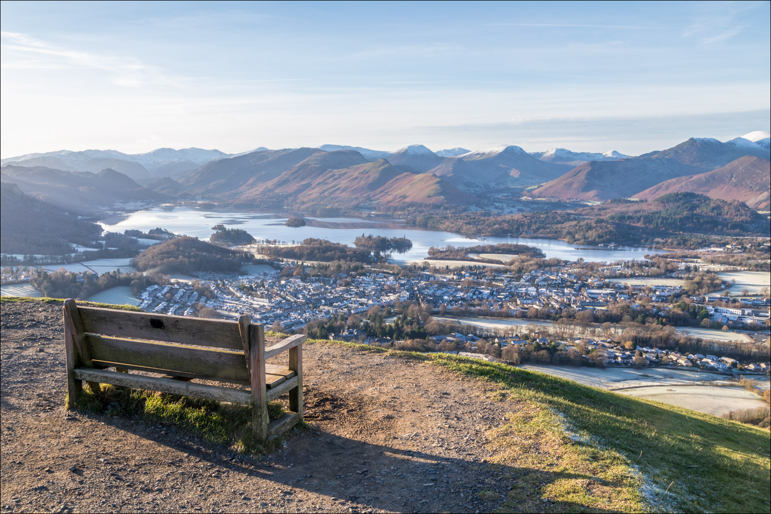
Before long we arrived at the wonderfully situated bench near the summit. We’d been keenly anticipating this moment and weren’t disappointed. The view was as glorious as ever – the rooftops of Keswick below, the full length of Derwent Water beyond, and an array of lakeland peaks, all displayed in early morning sunshine
Having savoured the views we started the descent along a grassy path which leads east along the Latrigg ridge. The angle is very gentle and it’s easy going all the way. On arriving at the end of the ridge we decided to take a new way back for us – a quiet lane which leads through Brundholme Wood. This contoured around the lower slopes of Latrigg, descending gently all the way down, and proved to be a very easy way back
For an alternative slightly longer return via the Keswick to Threlkeld Railway Track, click here and for a shorter 4 mile there and back version of the walk click here
Click on the icon below for the route map (subscribers to OS Maps can view detailed maps of the route, visualise it in aerial 3D, and download the GPX file. Non-subscribers will see a base map)

Scroll down – or click on any photo to enlarge it and you can then view as a slideshow

The start of the walk as we follow Spooney Green Lane, with Skiddaw left and our target, Latrigg, right

An early view across to Grisedale Pike and the north western fells

We walk through Latrigg Woods, where red squirrels may be seen

A glimpse of Bassenthwaite Lake as we enter onto open fellside

Snow capped Blease Fell in the background, and here we turn right at the start of the zig zag path up Latrigg...


Grisedale Pike again

Derwent Water comes into view

Looking back to Bassenthwaite Lake

The foot of Derwent Water and Keswick below

A wonderfully situated bench below the summit of Latrigg, but it was too cold to linger here

Keswick, Derwent Water and too many fells to list

Looking back to the bench as we continue to the nearby summit of Latrigg....


View from the summit of Latrigg

We continue along the ridge, with Blease Fell and the path to Blencathra ahead

That view again

Low Rigg and High Rigg, and the eastern fells beyond

Left to right - Blease Fell, the Pennines and Great Mell Fell

Scots pine and the eastern fells

We pass through this gate further along the ridge

The Pennines in the distance

Sheep grazing the fields as we follow the ridge...


At the end of the ridge, which is the far point of the walk, the path starts to curve around to the right

The last view to the east (Clough Head) as we turn west to head back to the start

We follow this track, which is traffic free as it's a dead end and serves no properties


Looking back to the spine of the eastern fells, culminating in Helvellyn

The views become restricted as we walk though Brundholme Wood

We cross a bridge over the A66 and enter the outskirts of Keswick

Back to the start, and a final look up to Latrigg as we reflect on the wonderful view from its summit...
