
Route: Latrigg
Area: Northern Lake District
Date of walk: 28th September 2019
Walkers: Andrew and Gilly
Distance: 4.0 miles
Ascent: 1,000 feet
Weather: Cloudy with sunny spells, windy on the top
The recent spell of mixed weather continued today, with some heavy rain and cloud covering most of the higher fells. By mid morning a few patches of sunshine started to appear, and we decided to climb one of the lower lakeland fells. Latrigg stands at an elevation of 1,203 feet, but punches well above its height in terms of the views from its summit. These are superior (in my opinion) to those from Skiddaw, which towers up behind it and is nearly 2,000 feet higher. The only drawback of the fell is that its proximity to Keswick, the ease of the ascent, and the superlative view make it a little too popular at times. This isn’t a walk I’d follow at peak times, unless setting off early
We parked as usual on the roadside at Briar Rigg and walked up Spooney Green Lane, crossing the bridge over the busy A66 along the way. After a while we joined the path leading to the top of Latrigg. The climbing was easy throughout and, as Wainwright puts it in his Guide to the Lakeland Fells, ‘anybody who cannot manage this short and simple climb is advised to give up the idea of becoming a fellwalker’
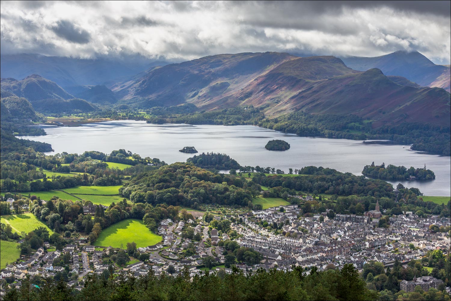
Before long we arrived at the wonderfully situated bench near the summit. We’d been keenly anticipating this moment and weren’t disappointed. The view was as glorious as ever – the rooftops of Keswick below, the full length of Derwent Water beyond, and an array of lakeland peaks, all displayed in fast changing and sometimes dramatic light
We lingered here for a while and having drunk our fill of the views we retraced our steps back to the start
For other walks here, visit my Find Walks page and enter the name in the ‘Search site’ box
Click on the icon below for the route map (subscribers to OS Maps can view detailed maps of the route, visualise it in aerial 3D, and download the GPX file. Non-subscribers will see a base map)

Scroll down – or click on any photo to enlarge it and you can then view as a slideshow

The day before the walk the rain stopped at last, leaving time for a quick visit to Lanthwaite Hill, here looking towards Loweswater village

Lorton Vale from Lanthwaite Hill....

Rannerdale Knotts...

...Lanthwaite Green

Lanthwaite Wood

Next day, the start of the walk as we follow the Cumbria Way through Latrigg Woods

Looking across to Bassenthwaite Lake...

..and now looking back to the north western fells, with a glimpse of Derwent Water on the left

We continue through the woodland, with autumnal colours beginning to show...


We pass through this gate to enter onto open fellside

North western fells again below some big skies

Another glimpse of Derwent Water

Lonscale Fell, part of the Skiddaw massif

Looking back along the path, illustrating the easy gradient on this ascent

A change of direction as we turn sharp right to follow the waymarked path...


More zigzags take the sting out of the climb...


Newlands Valley beyond the foot of Derwent Water


One of the classic benches in lakeland, just below the summit of Latrigg with a wonderful view of Keswick, Derwent Water and too many fells to list

Looking back to the bench as we make the short climb to the highest point of the fell

King's How and Castle Crag at the head of Derwent Water

Looking east towards Clough Head and St John's in the Vale...

...and now looking west to Newlands Valley

High Rigg and the eastern fells beyond

Keswick and Derwent Water again...


Zooming in on Keswick and the house on Derwent Isle

St John's in the Vale

At the far point of the walk, looking east to Great Mell Fell and the Pennines

We retrace our steps - here looking towards Causey Pike (left), and Barrow and Outerside in the foreground...
 from Latrigg today #keswick #lakedistrict #cumbria")

Waterfalls below Force Crag in full flow after heavy rainfall this week

Good light on Catbells

Applethwaite and Millbeck below Dodd, with Bassenthwaite Lake beyond

Skiddaw still in the clouds as we retrace our steps to the end of a wonderful short fell walk
