
Route: Lanthwaite Wood
Area: Western Lake District
Date of walk: 14th April 2021
Walkers: Andrew and Gilly
Distance: 2.1 miles
Ascent: 400 feet
Weather: Mixed sunshine and clouds
Today’s walk was a circuit of Lanthwaite Wood, owned and managed by the National Trust. It’s not just a woodland walk however, and has the bonus of visiting the viewpoint of Lanthwaite Hill, Crummock Water, and the River Cocker. This walk has featured on my site many times, but I take the view that no two walks are ever the same – changing seasons and variations in the light and weather make for an infinite number of possibilities – and there’s always something new to be seen
We parked as usual in the National Trust car park at Scale Hill. Instead of taking the obvious track ahead, which leads directly to the north shore of Crummock Water, we turned left up a steepish path through Lanthwaite Wood. At a junction we turned left again to continue uphill, climbing a steep rocky staircase along the way
After leaving the woods via a deer gate we were soon at the top of the hill, admiring the superb views over Lorton Vale, Loweswater and Crummock Water. The light was good and we lingered here for a while as the clouds scudded across the sky, watching patches of sunshine illuminate the surrounding fells
We then followed the easy path back down into Lanthwaite Wood, following a path which hugs the edge of the woods, giving good views across to Lanthwaite Green
The path descends to the eastern shore of Crummock Water, and when we arrived at the lakeshore we followed the path to the foot of the lake, from where there were more good views towards Mellbreak and Rannerdale Knotts. From this point there are two ways back to the start – a path which follows the bank of the River Cocker, and the wide track leading through Lanthwaite Wood. We opted for the riverbank path today, and 5 minutes later were back to the car park to end a short but very sweet walk
For other walks here, visit my Find Walks page and enter the name in the ‘Search site’ box
Click on the icon below for the route map (subscribers to OS Maps can view detailed maps of the route, visualise it in aerial 3D, and download the GPX file. Non-subscribers will see a base map)

Scroll down – or click on any photo to enlarge it and you can then view as a slideshow

After leaving the National Trust car park at Scale Hill we climb steeply uphill and follow the path on the left

After clambering up some rocky steps we arrive at the edge of Lanthwaite Wood, and pass through the deer gate in the direction of Whiteside

We follow the path up Lanthwaite Hill, also known as Brackenthwaite Hows

Sweet Lorton Vale

Looking back along the path towards Loweswater, where we'd walked yesterday

Lorton Vale from Lanthwaite Hill

Carling Knott and Holme Wood

Crummock Water from the top of Lanthwaite Hill...

...and Loweswater again

Lanthwaite Green and Rannerdale Knotts, with Great Gable in the background

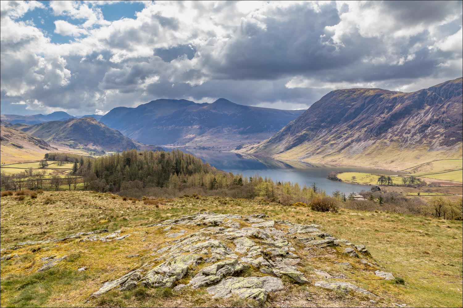
Looking over Lanthwaite Wood to Crummock Water, Red Pike and the foot of Mellbreak

Views of Carling Knott and Loweswater...


We descend from Lanthwaite Hill and re-enter Lanthwaite Wood

The path skirts around the edge of the wood and descends to the eastern shore of Crummock Water

We arrive at the boathouse

Mellbreak on the far side of Crummock Water

Crummock Water and Carling Knott

The boathouse again, looking towards Low Fell

We follow the shoreline path, here looking across to the lower slopes of Mellbreak

Low Fell from Lanthwaite Wood

We turn left beyond these pine trees and descend to the head of Crummock Water

The head of Crummock Water, with Mellbreak on the right

Red Pike and the foot of Mellbreak

Golden light on Crummock Water...


At the head of the lake, there's a choice of two routes back to the start - a track through Lanthwaite Wood and a narrower path beside the River Cocker

We chose the riverside path today

Back to the start, and a view across the River Cocker to Mellbreak
