
Route: The High Stile Range
Area: Western Lake District
Date of walk: 30th July 2015
Walkers: Andrew
Distance: 8.5 miles
Ascent: 2,800 feet
Weather: Extensive cloud cover but plenty of bright patches
The High Stile Range is one of the classic lakeland walks, visiting the 3 high fells which tower over the western shore of Buttermere – Red Pike, High Stile and High Crag in order of appearance
I parked in the National Trust car park outside Buttermere village and walked past the foot of the lake, leaving the lakeshore path to start the climb up to Red Pike. A rocky staircase took me much of the way but after reaching Bleaberry Tarn the going got tougher and the final pull to the summit of Red Pike was quite hard – very steep and loose underfoot. Having said that it’s better going up than coming down, which is why I did the walk anti-clockwise
The views from Red Pike were fantastic and after admiring them for a while I started the walk along the ridge, visiting the highest point High Stile at 2,644 feet and then High Crag
Next came the very steep descent down Gamlin End, tortuous on the knees and seemingly never ending. Eventually I arrived back down on the shore of Buttermere and from there it was a pleasant stroll back to the start of what had been a fantastic walk
For other walks here, visit my Find Walks page and enter the name in the ‘Search site’ box
Click on the icon below for the route map (subscribers to OS Maps can view detailed maps of the route, visualise it in aerial 3D, and download the GPX file. Non-subscribers will see a base map)

Scroll down – or click on any photo to enlarge it and you can then view as a slideshow

The evening before the walk, a red squirrel in the garden

Next morning, I walk past Crag Houses and look up to today’s objective - High Stile, the highest of the three fells in the High Stile Range

I pass by the Fish Inn as I leave Buttermere village to walk to the shore of the lake

Approaching Buttermere

Fleetwith Pike at the head of the lake

I cross Buttermere Dubs and leave the lakeshore path to head right uphill…

I climb the rocky staircase up through Burtness Wood

Out of the woods and onto open fellside

Looking back to Buttermere, Grasmoor is beyond with its head in the clouds

Fleetwith Pike

Rannerdale Knotts jutting out into Crummock Water

Sourmilk Gill tumbling down into Buttermere

Red Pike comes into view

Bleaberry Tarn and the gentle (at first) path leading up to Red Pike

Chapel Crags towering above the tarn

Looking along the path to High Stile

From the summit of Red Pike - Crummock Water, Loweswater, and the Solway Firth and Scotland in the distance

High Stile, The Scafells and Pillar

Walking along the ridge from Red Pike to High Stile

Bleaberry Tarn

Looking back to aptly named Red Pike - syenite in the rocks and subsoil causes the colouration

Zooming in on Gatesgarthdale Beck and the foot of Fleetwith Pike

Summit of High Stile, with Skiddaw and Blencathra in the background

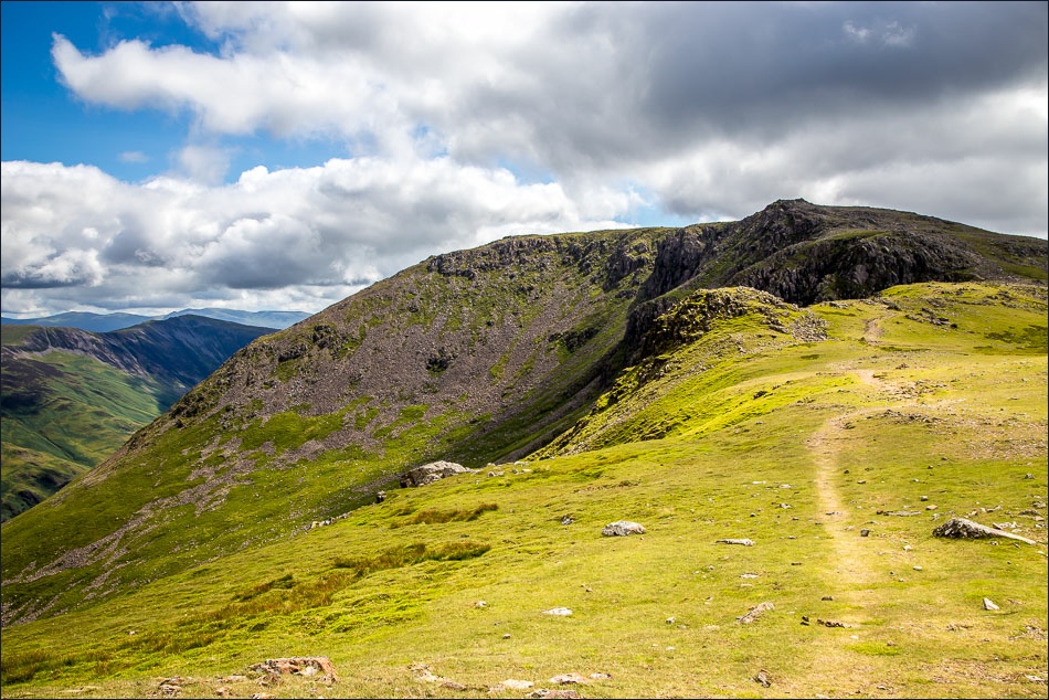
From High Stile I carry on along the ridge leading to the final fell on the round - High Crag

Buttermere on one side of the ridge…

…and Ennerdale and Pillar on the other

Ennerdale, Ennerdale Water, and the sea

Amazing views on both sides of the ridge - this is looking back to Buttermere and Crummock Water, with Scotland in the distance

Great Gable

Pillar again

Start of the very steep descent down Gamlin End towards Seat

Seat and Great Gable

At the foot of Gamlin End, I descend to the Scarth Gap path leading down from Haystacks

Buttermere


I follow the lakeshore path

The bothy

From the path back into Buttermere village, looking back to Fleetwith Pike

At the end of the walk I look up to High Stile and reflect on what a fantastic walk it had been
