
Route: Brackenthwaite Hows
Area: Western Lake District
Date of walk: 24th April 2024
Walkers: Andrew
Distance: 3.0 miles
Ascent: 800 feet
Weather: Sunny with a cold wind
Brackenthwaite Hows, otherwise known as Lanthwaite Hill, is situated near the head of Lorton Vale. This place has featured on my site many times, but no two walks are ever the same – changing seasons and variations in the light and weather make for an infinite number of possibilities, there’s always something new to be seen
As on the last occasion here I parked in one of the free spaces by Lanthwaite Green Farm. I crossed the Buttermere road and headed towards Whin Ben, a ridge which leads up to Whiteside. After crossing the footbridge over Liza Beck I followed the delightful path above Lorton Vale which runs for much of the length of the valley. It felt wonderful to be striding out along this familiar path, with lovely views along the way. The path to Beck House lies on the left and is easily missed. Look out for a gate in the wall. I left the valley path here and descended through a field to an area before Liza Beck, which is normally very boggy. Today was no exception. I crossed the beck via a footbridge and immediately after that crossed the Buttermere road. After passing by Pickett Howe I started the easy climb up the slopes of Brackenthwaite Hows, following a faint path not shown on the OS maps. Bluebells grow here in profusion in May and the display rivals its famous neighbour, Rannerdale
I continued to follow the line of the ridge before arriving at the top of Brackenthwaite Hows, also known as Lanthwaite Hill. The views were as good as ever, and a large chunk of the western Lake District may be seen from here including Crummock Water, Loweswater and Lorton Vale
I descended towards Crummock Water and entered Lanthwaite Wood via a deer gate. I then followed a path beside a dry stone wall at the edge of the wood. Near the edge of the wood I followed a path out of it back to Lanthwaite Green and to the end of the walk
For other walks here, visit my Find Walks page and enter the name in the ‘Search site’ box
Click on the icon below for the route map (subscribers to OS Maps can view detailed maps of the route, visualise it in aerial 3D, and download the GPX file. Non-subscribers will see a base map)

Scroll down – or click on any photo to enlarge it and you can then view as a slideshow

Earlier in the day, a red squirrel in the garden

View of Mellbreak from the car park at Lanthwaite Green

I head the other way and cross the road in the direction of Whin Ben and Whiteside

I cross the footbridge over Liza Beck

Looking across to the Loweswater fells on my left

Dry stone wall at the foot of Whiteside. I follow the path beside the wall, which runs along Lorton Vale for miles

Lookng back to the start, and a glimpse of Crummock Water below Mellbreak

Lorton Vale

An inquisitive herdwick

Further along the valley path, which I'll leave on reaching the green fields ahead

Another view back to Mellbreak

I'm aiming for the ridge of Brackenthwaite Hows which can be seen below the Loweswater fells

I leave the valley path here and follow the line of the dry stone wall towards Beck House...


After a short boggy section I cross Liza Beck for the second time and then cross the nearby Buttermere road

The path passes by Pickett Howe, with Low Fell in the background

I pass through this deer gate and enter onto Brackenthwaite Hows

The start of the easy climb up Brackenthwaite Hows. This area will be carpeted with bluebells in a couple of weeks time

I continue along the ridge, which curves gradually round to the right

Looking across to Grasmoor, and Lanthwaite Green where I'd started the walk

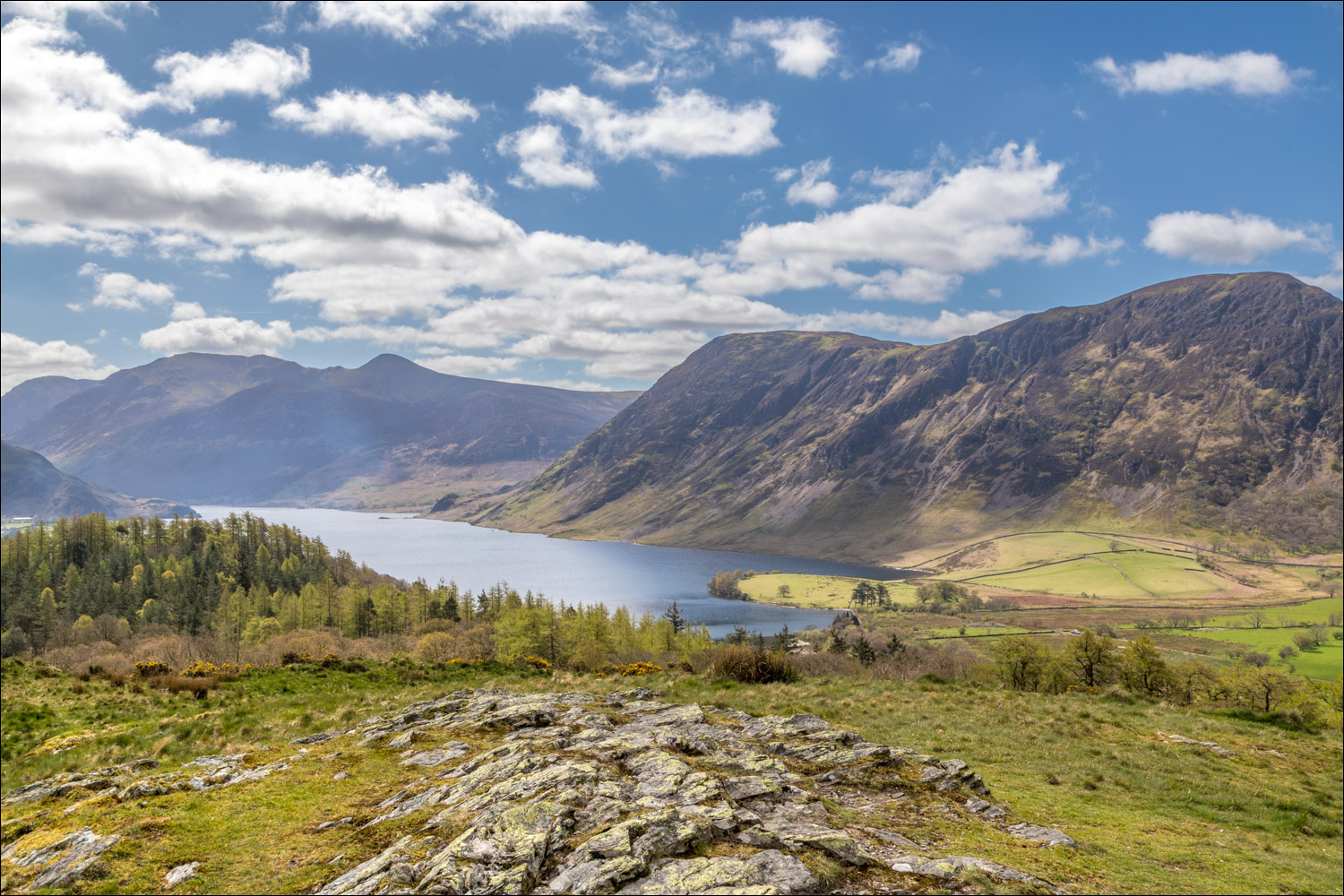
Crummock Water from the top of Brackenthwaite Hows, or Lanthwaite Hill

Holme Wood and Loweswater - the lake itself can't quite be seen from here

The start of the descent in the direction of Crummock Water

I follow a path around the edge of Lanthwaite Wood...


I leave Lanthwaite Wood and head towards Whiteside

Lanthwaite Green ahead and the end of a wonderful short walk
