
Route: Wast Water
Area: Southern Lake District
Date of walk: 12th February 2020
Walkers: Andrew
Distance: 4.8 miles
Ascent: 300 feet
Weather: Mostly cloudy, with a few bright patches
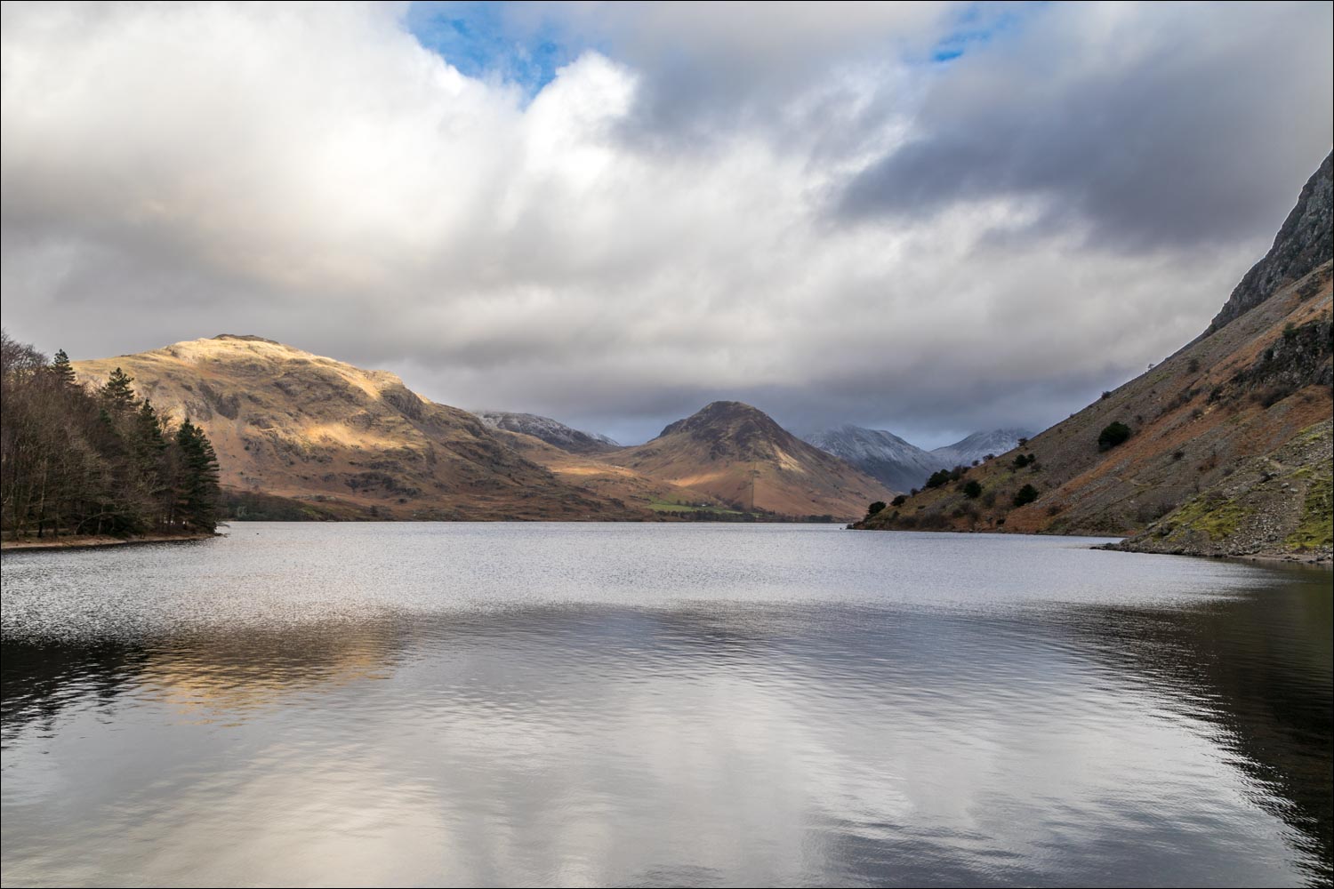
Wast Water, also known as Wastwater, is the deepest of all the lakes in the district, and the view along it to the head of Wasdale is one of the finest in the country. The area at the foot of the lake, Nether Wasdale, is ideal for a low level walk and it’s quiet too – I only saw 3 other walkers on today’s circuit
I parked in a small car park by Cinderdale Bridge at a triangle of roads just beyond Nether Wasdale. After turning right out of the car park I crossed the bridge over the River Irt and joined the track leading to Easthwaite. After passing through the farm I headed towards the foot of Wast Water. The path to Lund Bridge is clearly shown on the OS map as a public footpath, but there is a sign on the gate ‘PRIVATE – no public right of way’. This wasn’t an issue, as the so-called private path may be circumvented by visiting the boathouse at the foot of the lake – a worthwhile diversion. Having done so, I walked along the bank of the River Irt, crossed over Lund Bridge, and then walked back along the other bank of the river, around the edge of Low Wood
I soon arrived at the foot of Wast Water, where there is a wonderful view along the lake to some of the most impressive peaks in the Lake District. I continued along the lakeshore path and just beyond Wasdale Hall I climbed up to the road, which I followed for a short distance before turning off at High Birkhow. The track beside the wood, and through the open countryside at Ashness How, is a muddy one at the best of times and today was no exception. Beyond Ashness How I turned off to follow the path to Scale Bridge and from there walked along the very pleasant path back to the start
For other walks here, visit my Find Walks page and enter the name in the ‘Search site’ box
Click on the icon below for the route map (subscribers to OS Maps can view detailed maps of the route, visualise it in aerial 3D, and download the GPX file. Non-subscribers will see a base map)

Scroll down – or click on any photo to enlarge it and you can then view as a slideshow

Having parked by Cinderdale Bridge in Nether Wasdale, I follow the track to Easthwaite Farm

The Wasdale Screes ahead

The Screes again, looking to the head of the valley, with Wast Water as yet unseen

Approaching Easthwaite Farm

Looking across to Middle Fell

Yewbarrow

Beyond the farm now, I continue to follow the track towards the foot of Wast Water

Buckbarrow and Middle Fell

The Screes above, and Wast Water just around the corner

I make a there and back detour to see the boathouse at the foot of Wast Water

Yewbarrow at the head of the lake...

From here I retrace my steps for a short distance

I cross over the River Irt via Lund Bridge

I follow a path around the edge of Low Wood (a good place to see bluebells in season)

The boathouse again, this time on the other side of the river

I follow the path across the foot of Wast Water

Yewbarrow, Kirk Fell and Great Gable at the head of the lake...


A small unnamed island, the only one in Wast Water

I arrive at the road, the half way point of the walk, and turn back here to start the return leg

Looking back to the Wasdale Screes - there is a path of sorts along the far side of the lake - I tried it once, but am unlikely to repeat the experience

I leave the road and join a path across Ashness How, here looking over to Yewbarrow

There are good views back to the fells at the head of Wast Water from here

Lingmell - the Scafells are in the clouds


Buckbarrow...


I follow the path across Ashness How, which is rough and wet

Another view back as dark clouds pass over the head of Wast Water


It's hard to resist glancing back from time to time...


Buckbarrow again


Gentle rolling scenery as I head away from the lake


Whin Rigg and Illgill Head on my left, with the Screes plunging down from them

I pass through Mill Place, a National Trust property - the end of the walk lies just around the corner

Having finished the walk, I drive back along Wast Water for the classic view to the head of the lake...

...a view which was voted 'Britain's Favourite View' in 2007

I then drove to the head of the lake, where there were dramatic views of the crags on Scafell Pike...


