
Route: Swineside Knott
Area: Eastern Lake District
Date of walk: 7th February 2020
Walkers: Andrew
Distance: 4.0 miles
Ascent: 1,000 feet
Weather: Sunshine and blue skies, very windy on the tops
Swineside Knott is the highest point on Watermillock Common at a respectable height of 1,814 feet. It doesn’t qualify as a Wainwright fell as it’s merely part of the eastern ridge of Stybarrow Dodd. I was last here almost exactly a year ago and, although the weather was indifferent, I’d seen enough to know that the views of Ullswater from here are superb. I promised myself that I’d return in better weather, and today was that day. There was sun and blue skies as I drove to the east of the district, where I parked in the National Trust car park at Park Brow, near Aira Force
I crossed the road following a sign for Glencoyne Head to start the ascent, which was so gentle in the early stages that it was hardly noticeable. It was good to see a red squirrel scampering up a tree during along the way. This is one of the best paths for viewing Ullswater, and the views improve as height is gained.
Eventually I arrived at a dry stone wall and a gate, which marked a change of direction. I followed the dry stone wall below Swineside Knott for a short distance, and pondered whether to climb to the highest point, which is a 5 minute pathless but easy ascent. In the event I decided to give it a miss, as I was trying a new route back and this would have meant a detour. Last time here I’d descended via Common Fell and Dockray, but today I tried a shorter route. The path was beside a rollercoaster dry stone wall, with more wonderful views of Ullswater all the way down. I made a short detour to the viewpoint of Round How, a perfect picnic spot in normal weather, but today I could hardly stand up in the teeth of the fierce wind, so didn’t linger there
After passing through a gate I arrive above Brunt Crag. It’s possible to descend directly beside the wall, but there’s a very steep rocky section lower down and as the rocks were wet and slippery I walked above the crag and found an easier pathless way down. I followed a sodden grassy track round Park Brow and this brought me back down to the car park, and the end of a superb walk
During the course of nearly three hours, I’d enjoyed almost constant views of Ullswater and I hadn’t seen another soul
For other walks here, visit my Find Walks page and enter the name in the ‘Search site’ box
Click on the icon below for the route map (subscribers to OS Maps can view detailed maps of the route, visualise it in aerial 3D, and download the GPX file. Non-subscribers will see a base map)

Scroll down – or click on any photo to enlarge it and you can then view as a slideshow

The start of today's walk from the National Trust car park at Park Brow - Aira Force is a short stroll from here, but my path lies in the opposite direction

I cross the road and follow the sign - the path goes to Glencoyne Head, but I'll leave it about half way along

The first of many views of Ullswater - the lake is in sight throughout most of the walk

Sheffield Pike left of centre. Swineside Knott lies behind the trees

Glencoyne Park below, looking towards the head of Ullswater

The path climbs above Glencoyne Park at an easy gradient

Looking towards the foot of Ullswater, with Hallin Fell in the centre

A final view towards the head of the lake - blinding sunshine was moving behind it and made it impossible to take any more photos in that direction

Swineside Knott ahead

Looking back over Glencoyne Park

I pass through this gate into a small woodland

Looking back - one of the Ullswater Steamers is plying its trade below...


Wind battered beech trees in the small woodland


Sheffield Pike on my left as I continue uphill

More wind battered trees - it was blowing a gale up here, which slowed my progress

The Pennines in the distance

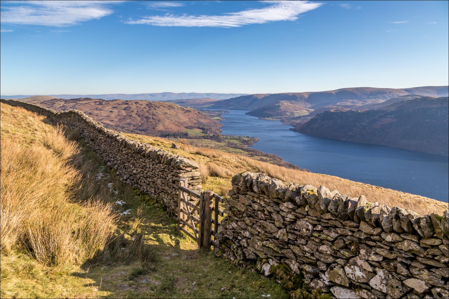
This gate marks the half way point of the walk and a change of direction

I follow a path beside the dry stone wall, which will be my constant guide throughout the descent...

The summit of the fell can be gained by a pathless ascent on the left, a little further along, but the views are no better so I gave it a miss today

Looking back to Birkhouse Moor and Sheffield Pike

Wonderful views over Ullswater on the way down...

The path, and the dry stone wall, lead in the direction of Gowbarrow Fell

Looking back to Swineside Knott

The main path leads back to Dockray, but I branch off to the right to keep beside the dry stone wall. Great Mell Fell is on the left of the picture

The lower slopes of Gowbarrow Fell on the far side of Aira Beck

A wider view showing Gowbarrow Fell

Blencathra on my left

Gowbarrow Fell again

Great Mell Fell

I pass through this gate above Brunt Crag - a faint path follows the wall downhill but it's very steep lower down, and I found it preferable to walk above the crag and find an easier way down

The road is below and this leads back to the car park...

...but it's preferable to follow this grassy path, which leads directly back to the start
