
Route: Dale Head and Hindscarth
Area: North Western Lake District
Date of walk: 16th May 2019
Walkers: Andrew and Gilly
Distance: 7.7 miles
Ascent: 2,400 feet
Weather: Sunny with a cool breeze
On a beautiful morning in lakeland we parked at the small car park by Chapel Bridge just beyond Little Town. We turned left at Newlands Church to follow the track towards the head of the valley. Before long we could see our target, Dale Head, at the head of Newlands Valley. After passing through Low Snab farm we crossed a wooden footbridge over Newlands Beck and followed the path past the old climbing hut
The ascent route which we’d chosen is one we first walked 5 years ago (click here). It’s an unfrequented route along a faint path which we’d read about in Alfred Wainwright’s guides and one which he describes as a ‘mountaineering must’. Instead of ascending to Dalehead Tarn via the usual route, we left the main path at Near Tongue Gill to follow the wonderful path which passes the old copper mine. The route ingeniously finds a way above the steep cliffs of Dalehead Crags without any sense of exposure, and it’s perfectly safe
We arrived at a col just below the summit of Dale Head, and paused to chat to a passing fellow walker – up to this point we’d had the place to ourselves, another reason for recommending this route
After admiring the superb view from the shapely summit cairn on Dale Head we followed the ridge known as Hindscarth Edge, from where there are views in all directions, including most of lakeland’s finest fells. From the summit of Hindscarth we set off on the long descent, which has a few steep rocky sections, particularly on Scope End. There are no dangers, but some ungainly manouevres are needed
We arrived back at the start reflecting on how lucky we’d been today to enjoy such incredible scenery on such a lovely day – it had been a really great walk
For other walks here, visit my Find Walks page and enter the name in the ‘Search site’ box
Click on the icon below for the route map (subscribers to OS Maps can view detailed maps of the route, visualise it in aerial 3D, and download the GPX file. Non-subscribers will see a base map)

Scroll down – or click on any photo to enlarge it and you can then view as a slideshow

Earlier in the week, a variety of finches filling their beaks on the feeders - I think they're feeding young families as well as themselves

Spring flowers in the garden...


The morning of the walk, and I made a quick dawn visit to the head of Crummock Water, here looking towards Haystacks

Canada geese enjoying a golden start to the day near Woodhouse Islands...


The start of today's walk as we cross Chapel Bridge and head towards Newlands Church

Newlands Church - Wordsworth visited this place in May 1826, and this inspired his poem 'To May'

Having turned left at the church we follow the track towards the head of the valley, with Hindscarth and Robinson on the right

Scope End on the right, which will be our return route

Maiden Moor and High Spy up on the left

Approaching Low Snab...


We duly shut the gate but sorry, we forgot to bring the Cooper's Dip

We continue along the heavenly path, with Dale Head dominating the scene

Hindscarth on the right


We cross the footbridge over Newlands Beck

Not another soul around as we follow what must be one of the loveliest paths in the district

The traditional path to Dale Head continues up the valley, but we turn off right shortly to follow a faint path on the right as recommended by Wainwright

Off we go - Dale Head is up on our left...


Looking back along Newlands Valley to Skiddaw

The gradient steepens but it's an easy climb

The path will take us above Dalehead Crags to the left

Looking back to High Spy

Our path finds its way above the crags

We pass by an old mining hut, here looking back along the valley

High Spy with my little eye

The path steepens near the top

We arrive at a col above the crags, here looking back along High Spy and Maiden Moor towards Skiddaw

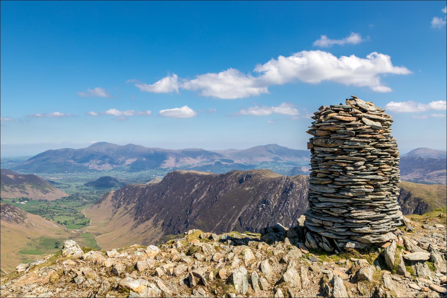
Summit cairn on Dale Head, one of the best in the district

We leave the summit and walk along Hindscarth Edge

A view back down the valley, with Skiddaw and Blencathra in the distance

Further along Hindscarth Edge

Looking across to Honister Crag and Honister Pass

Buttermere comes into view

We continue along the easy ridge, and will turn right at the fork ahead

A view back, and on the right is the ascent path we'd taken earlier

Summit of Hindscarth

We carry on down the ridge towards a subsidiary cairn below

This wonderful view is ahead of us all the way down, causing a serious slip and trip hazard, so watch your feet ...


Looking back to Hindscarth

Scope End ahead...


Newlands Valley and Causey Pike to the left

Looking back to Hindscarth left and Robinson right

Newlands Church comes into view below...


Back to valley level, and we retrace our steps back to the start

A last lingering view back to Dale Head at the end of a wonderful walk
