
Route: Crummock Water and Lanthwaite Hill
Area: Western Lake District
Date of walk: 19th December 2014
Walkers: Andrew
Distance: 4.7 miles
Ascent: 800 feet
Weather: Mostly overcast with some brighter spells
I parked in the National Trust car park at Scale Bridge and, instead of heading along the wide track to the foot of Crummock Water, I turned uphill and climbed up the rocky staircase which leads to the top of Lanthwaite Hill (or Brackenthwaite Hows as the OS calls it)
The views from the top are wonderful – in all directions – and after admiring them for a while I retraced my steps for a short distance before heading downhill in the direction of Brackenthwaite. Having reached the bottom, I crossed the Buttermere road and walked uphill to join the footpath running along the eastern side of Lorton Vale, one of my favourite paths in the district
This took me to Lanthwaite Green, and after entering Lanthwaite Wood I made my way down to the boathouse on the shore of Crummock Water. I walked along the shore, round the foot of the lake and at the Pump House I turned to walk back to the start via a wide track and then a quiet lane
Although I’ve walked these paths on many occasions, this is the first time I’ve put them together to make a variation on our usual walks around here. It was a wonderful walk and I’m sure I’ll repeat it again
For other walks here, visit my Find Walks page and enter the name in the ‘Search site’ box
Click on the icon below for the route map (subscribers to OS Maps can view detailed maps of the route, visualise it in aerial 3D, and download the GPX file. Non-subscribers will see a base map)

Scroll down – or click on any photo to enlarge it and you can then view as a slideshow

The start of the walk from the Scale Bridge car park

I take the left fork

The rocky path up Lanthwaite Hill

The huffing and puffing is soon over and the hilltop lies ahead - Whiteside and Grasmoor are behind it

Whiteside

Sweet Lorton Vale

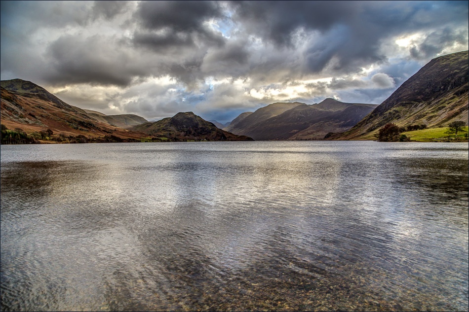
Crummock Water, Rannerdale Knotts and the High Stile Range

Rannerdale Knotts

Crummock Water again from the top of Lanthwaite Hill

Looking towards Loweswater (can you spot the Lowewater pheasant?)

Looking down to Gasgale Gill and Lanthwaite Green, where I’ll be later

Descending from Lanthwaite Hill in the direction of Low Fell and Fellbarrow

Whiteside looks down on a woodland of the future

Crossing the Buttermere Road at Beck House

and crossing the beck

I’m now on one of my favourite paths - this is looking back down Lorton Vale

Looking across the valley to Low Fell

Further along the path, Red Pike is the pointed fell in the distance

Lanthwaite Hill, where I’d been earlier

Further along this heavenly path

At this point I head back down towards Crummock Water

I cross the bridge over Gasgale Gill

Looking up the gill from the bridge

And from the same place looking down it, towards Lanthwaite Hill and Low Fell

Crummock Water - and Mellbreak

Heading into Lanthwaite Wood from Lanthwaite Green Farm


In Lanthwaite Wood

The boathouse on the eastern shore of Crummock Water

Mellbreak in the background

Walking along the eastern shore towards the foot of the lake

Crummock Water

The weir at the foot of Crummock Water

The light was changing by the minute, and I took a few photos looking towards Rannerdale Knotts


Looking along Park Beck to Whiteside and Grasmoor

On the path to Muncaster House, looking back to Crummock Water

The lane back to Scalehill Bridge

Scalehill Bridge - the car park is ahead

A last lingering look back towards the Western Fells before I arrive back at the start
