
Route: Whiteside and Hopegill Head
Area: North Western Lake District
Date of walk: 18th September 2020
Walkers: Andrew and Gilly
Distance: 6.6 miles
Ascent: 2,600 feet
Weather: Sunshine and blue skies with weak clouds
My last visit to Whiteside was two years ago, and on that occasion I started from the gated road to High Swinside. In order to get the climbing out of the way early, we decided to start from Lanthwaite Green today, where there is free parking in the small car park at the foot of Whiteside. After crossing the Buttermere road, and then Liza Beck via the footbridge, we arrived at the foot of Whin Ben. This is ‘incomparably the best route up’ according to Wainwright, and here the collar work begins. There are 3 steep sections along the way when hands need to be taken out of pockets: the final section before Whin Ben top, a rocky mount mid way between Whin Ben and Whiteside, and the final push to the summit. These all involve some enjoyable and perfectly safe clambering, though I wouldn’t like to descend this way. There are some lovely views back over Crummock Water and, higher up, dramatic views down into Gasgale Gill
We eventually arrived at the summit cairn, which is not the highest point and, after gazing at the views for a while, we made our way along to the true summit. Beyond here lies the wonderful ridge to Hopegill Head, a temptation which I couldn’t resist. Gilly decided not to follow and she descended via the Dodd ridge. We’d meet up later. I carried on along the ridge, and would return the same way, adding about two miles to the route. It’s a wonderful path and, although there are steep drops on both sides, they’re not so precipitous as to induce feelings of exposure. After reaching Hopegill Head and returning along the ridge I started the gentle descent down the path to Lorton Dodd. This provides an easy way off the fell. On arriving at Dodd Pass I headed down towards Hope Beck and followed a path which contours around the fellside
The path gradually curves round into Lorton Vale, and there follows a lovely elevated walk along the valley, with a dry stone wall on the right being a constant companion. The path eventually brought me back to the bridge over Liza Beck, completing the circuit, and from here it was a short stroll back to Lanthwaite Green
For other walks here, visit my Find Walks page and enter the name in the ‘Search site’ box
Click on the icon below for the route map (subscribers to OS Maps can view detailed maps of the route, visualise it in aerial 3D, and download the GPX file. Non-subscribers will see a base map)

Scroll down – or click on any photo to enlarge it and you can then view as a slideshow

Red squirrel in the garden this morning

A short while later, the start of the walk. This is the view of Mellbreak from the car park at Lanthwaite Green

The key to the ascent route is the prominent hump of Whin Ben below Whiteside

We cross the bridge over Liza Beck

Looking back over the bridge to the car park, with Crummock Water and Mellbreak beyond

Loweswater fells

Another view back to Mellbreak and Crummock Water

The narrow path twists and turns up the flank of Whin Ben, with a scrambly section just below its top

Another view back to the start, and to Mellbreak and Crummock Water

Above Whin Ben now, Gilly contemplates the way ahead

Looking back over Whin Ben to Crummock Water, with Loweswater right of picture

Another rocky section above Gasgale Gill

Gasgale Crags on our right

A dramatic view down into Gasgale Gill

A view back along the path...

...and again, with Loweswater on the right

Looking along Gasgale Crags to Hopegill Head, the furthest point of the walk, and to Sand Hill

Gasgale Crags

Gasgale Crags and Gasgale Gill

We arrive on the summit ridge of Whiteside

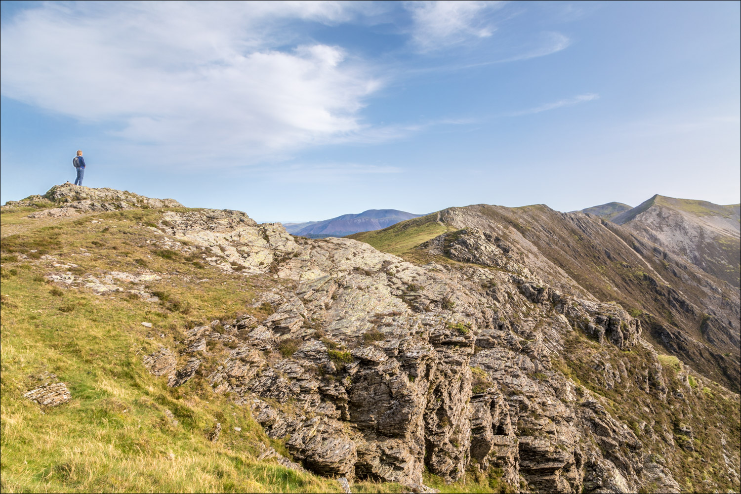
Looking along the wonderful ridge from Whiteside to Hopegill Head, one of the best in lakeland

A fearsome drop down Gasgale Crags to Gasgale Gill

The summit of Whiteside is ahead

Looking back along the path

We agree to go different ways here, and while Gilly descends to Lorton Vale, I continue along the ridge and will be back at this spot in 40 minutes or so

Crummock Water from Whiteside

Looking along the ridge from Whiteside to Hopegill Head

Further along the ridge

Grisedale Pike and Hobcarton Crag from the small summit on Hopegill Head

Looking west from the summit of Hopegill Head, and from here I retrace my steps along the ridge...


I arrive back at the summit of Whiteside and turn right here to start the descent

I follow a faint path heading north down the slopes of Lorton Dodd

Looking over Lorton and Cockermouth to the Solway Firth and to Criffel in Scotland, some 30 miles away

After reaching a hause below Dodd I descend into the valley, here looking back up to Hopegill Head

The path contours around the flanks of Dodd, gradually curving left into Lorton Vale

Looking across Lorton Vale to Thackthwaite at the foot of Fellbarrow and Low Fell

Lorton Vale

I pass by the outgang above Miller Place

Navigation is straightforward - just keep the dry stone wall on your right

Brackenthwaite Hows

On the home straight now

Looking across to Low Fell and the Loweswater fells

Grasmoor

I arrive back above Lanthwaite Green and from here cross the bridge over Liza Beck and retrace my steps back to the start
