
Route: Dinas Island
Area: Pembrokeshire
Date of walk: 24th September 2020
Walkers: Andrew and Gilly
Distance: 3.6 miles
Ascent: 600 feet
Weather: Mixed sunshine and clouds, showers, and hail near the end. Very strong winds
We first visited the Pembrokeshire coast this time last year and on that occasion enjoyed several wonderful walks in the south of the area. This year we’d decided to explore the northern section. Our first walk would take us around Dinas Island which, confusingly, is not an island at all, but a peninsula. It’s not a completely misleading name however, as the ‘neck’ of the peninsula, Cwm Dewi, is only just above sea level (my gps recorded it as slightly below sea level)
Anyone following this walk would start from the tiny seaside villages of Pwllgwaelod or Cwm-yr-Eglwys. In our case, we were staying in a holiday cottage at Ffynnonofi Farm (which we can highly recommend), and walked through the fields to nearby Pwllgwaelod, where there is a small car park, a cafe and a beach. We decided to walk the circuit in a clockwise direction and set off along the well waymarked coastal path
We climbed out of the village up to the cliff top, following the Wales Coast Path. There were superb views back along the coast from here. A sudden downpour caused us to take shelter for a while, but the strong winds soon blew it over and we continued above the cliffs, looking down to a stony beach at one point where a pair of seals were resting. After various ups and downs we arrived at Dinas Head, where a trig column surmounts Pen y Fan
This marked the halfway point of the coastal section and, as we rounded the headland, views of Newport Sands appeared. The path split here, giving a choice of high or low level walks. We decided to follow the narrower low level path which passes above the soaring stack of Needle Rock. There were a couple of sharp drops to our left, and these could be avoided by taking the higher level route
We arrived in the tiny hamlet of Cwm-yr-Eglwys, where the ruins of the old church look out to sea – a lovely spot. This marked the end of the coastal section and from here we followed a well made path through a wooded vale across the neck of the peninsula. This soon brought us back to Pwllgwaelod to finish a wonderful short walk
Click on the icon below for the route map (subscribers to OS Maps can view detailed maps of the route, visualise it in aerial 3D, and download the GPX file. Non-subscribers will see a base map)

Scroll down – or click on any photo to enlarge it and you can then view as a slideshow

We arrived at our holiday cottage the afternoon before the walk, and at dusk strolled through the fields to the nearby coast - Dinas Island is in the background

Next day, and a promising start as we leave the cottage and walk towards Dinas Island

Anyone following this walk is recommended to start here - the small fishing village of Pwllgwaelod

Pwllgwaelod beach


We climb up to the cliffs to start our clockwise circuit of Dinas Island

We follow the Wales Coast Path...


We pass above a stony beach

Zooming in on a pair of seals - this is breeding season, and we had some good sightings during our walks in the area

Views back along Fishguard Bay...


We walk towards Pen y Fan above Dinas Head

Newport Bay on our right

Looking back along the path

We arrive at the trig column on Pen y Fan...


Looking out to sea

As we round the head of Dinas Island, Newport Bay comes into view

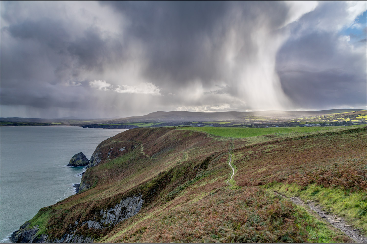
Dramatic skies, as a sudden hailstorm passes overhead

Thanks to high winds, the storm passes quickly. There's a choice of paths beyond this point, and we take the lower one, which passes above Needle Rock

Newport Bay

We head towards Needle Rock, which teems with breeding guillemots and razorbills in early summer

We round the corner to head towards Cwm-yr-Eglwys...


Cwm-yr-Eglwys

St Brynach's Church, Cwm-yr-Eglwys - only the belfry and west wall remain of the 12th century church, which was destroyed in the great storm of October 1859

We leave Cwm-yr-Eglwys and walk across the neck of the peninsula, a pleasant short stroll but with no views, and arrive back at the start in Pwllgwaelod

The end of our first walk on the North Pembrokeshire coast, one which had been full of interest and beauty, and we look forward to tomorrow's walk...

The sun sets, and we look forward to tomorrow's walk
Follow the link for more walks in Wales (17)
