
Route: Great Crag
Area: Central Lake District
Date of walk: 17th August 2019
Walkers: Andrew and Gilly
Distance: 5.6 miles
Ascent: 1,400 feet
Weather: Cloudy with sunny patches and a few spots of rain. Very windy on the tops
It was two years ago to the day that I last visited Great Crag, a mid-level lakeland fell which is covered with a coat of purple heather at this time of the year
As on the last occasion we parked in the small hamlet of Stonethwaite and crossed the beck via Stonethwaite Bridge, turning right immediately to join the Cumbria Way for a short distance. We then left the Cumbria Way to join a path heading uphill which followed the course of Willygrass Gill. The gill was on fine form after yesterday’s incessant rain. It was a steep climb, but the addition of rock steps made the ascent a straightforward affair and before long we arrived at Dock Tarn
The tarn is surrounded by numerous mounds and tors, all covered with heather, and it’s a lovely sight. As Wainwright says, ‘Dock Tarn is a place to lie adreaming, and life seems a sweet sweet thing’. Great Crag is a complicated place, full of ups and downs, and determining the summit and the path to it is not a simple affair. There are numerous small paths, some of which peter out. We simply aimed for the highest point and, after some meandering, arrived there. Another top with a slightly larger cairn was nearby, so we visited that too. Both were wonderful spots
We then rejoined the main path below and descended towards Watendlath. We were a little short of time to visit this remote hamlet, as I’d done last time here, and we took a shortcut across some wild and very juicy terrain leading to Puddingstone Bank. The path descended alongside Bowdergate Gill, with wonderful views into Borrowdale, before merging with the Cumbria Way lower down. From here it was a short stroll beside Stonethwaite Beck back into Stonethwaite, and the end of a superb walk
For other walks here, visit my Find Walks page and enter the name in the ‘Search site’ box
Click on the icon below for the route map (subscribers to OS Maps can view detailed maps of the route, visualise it in aerial 3D, and download the GPX file. Non-subscribers will see a base map)

Scroll down – or click on any photo to enlarge it and you can then view as a slideshow

A brief history of Stonethwaite on a barn door in the village

Stonethwaite, and the start of today's walk

We cross Stonethwaite Beck via Stonethwaite Bridge and turn right

The imposing face of Eagle Crag at the head of the valley

Looking back to Stonethwaite at the start of the climb, gentle at first but gradually becoming steeper and rockier (though without difficulties)

Bonnie climbs the ladder stile

Willygrass Gill, our companion for most of the ascent

Having walked here 2 years ago, I knew there'd be heather around, and I wasn't disappointed

Looking back down the path

We pass by the ruins of an old building, here looking back to Eagle Crag and Sergeant's Crag

Heather, a scenic highlight of the walk...


Willygrass Gill on our right as we continue up the zigzagging path

Lovely light on Bessyboot on the far side of Borrowdale

Langstrath and its beck below

Looking back along the path

The retrospective views towards Langstrath and Rosthwaite Fell were shown in good light today...


Looking along Willygrass Gill

Dock Tarn, a rather prosaic name for such a magical place

We follow an undulating path along its western side

A small unnamed island in the tarn


A last look back to the tarn as we continue towards our objective, Great Crag

We follow a waterlogged path away from the tarn

Borrowdale on our left...

Another view into Borrowdale from the summit of Great Crag

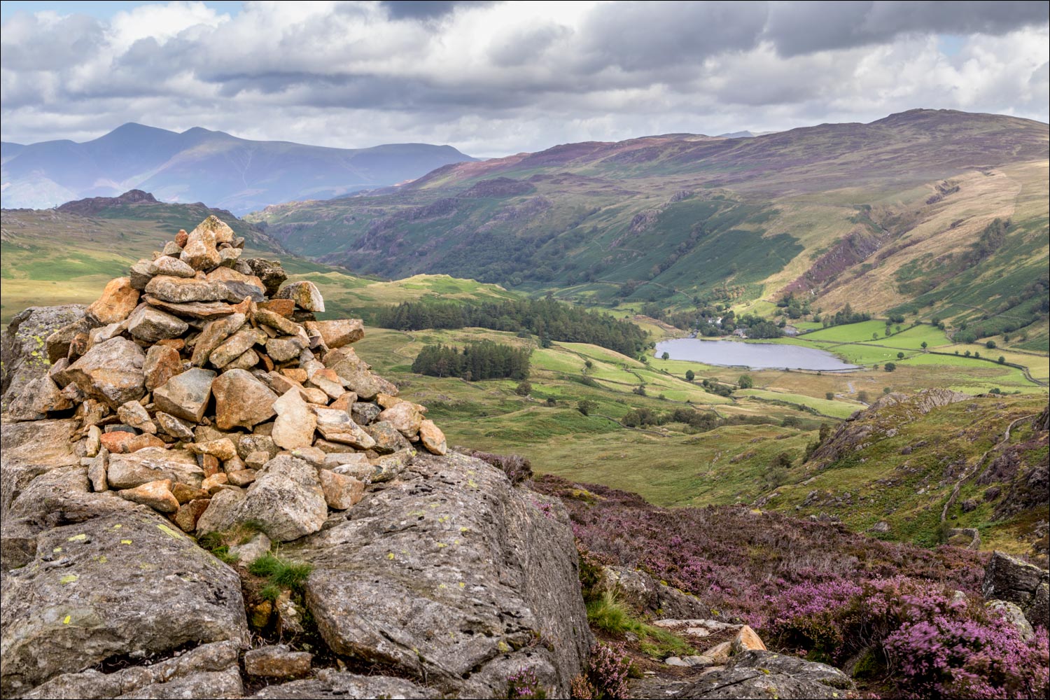
The summit cairn on Great Crag, looking towards Watendlath and its tarn, with Skiddaw in the background

Borrowdale from the summit...

...and now looking back to Dock Tarn, with Ullscarf in the distance

We now set our sights on the descent, heading at first towards Watendlath and its tarn, but then taking a shortcut to the left

Remote and soggy terrain as we walk in the direction of Grange Fell...


A change of direction as we meet up with the path beside Bowdergate Gill and descend into Borrowdale...

...it's a heavenly path, with new vistas around every corner...


Rosthwaite below


Our destination, Stonethwaite, comes into view...


We continue to follow the valley path, part of the Cumbria Way

Looking back along Borrowdale

Further along the valley path, with Eagle Crag ahead...


We leave the valley path and turn right to walk back into Stonethwaite

The circuit is complete as we re-cross Stonethwaite Bridge and arrive back in the village
