
Route: Middle Fell
Area: Western Lake District
Date of walk: 31st March 2016
Walkers: Andrew and Gilly
Distance: 4.2 miles
Ascent: 1,700 feet
Weather: sunny
We parked on the roadside verge just beyond the small hamlet of Greendale in Wasdale and followed the grassy path leading gently uphill. The path steepened as we gained height and gradually became rockier as we traced a course along the bank of Greendale Gill, which tumbles down the fellside from Greendale Tarn in a succession of small cascades
Eventually we reached the tarn and followed a faint path above it, turning sharp right to climb up the ridge to the summit of Middle Fell. It was easy going all the way
The views from the top were wonderful, particularly looking towards the Scafells. After a picnic near the top we followed the line of the ridge back down to Greendale Gill, where we picked up our original ascent path and retraced our steps back to the start, enjoying dramatic views of the Wastwater Screes as we did so
This is a superb short walk, one that seems much longer than it is, and is ideal for anyone who visits Wasdale with insufficient time or energy to tackle one of the nearby giants
For other walks here, visit my Find Walks page and enter the name in the ‘Search site’ box
Click on the icon below for the route map (subscribers to OS Maps can view detailed maps of the route, visualise it in aerial 3D, and download the GPX file. Non-subscribers will see a base map)

Scroll down – or click on any photo to enlarge it and you can then view as a slideshow

The day before the walk, some colourful garden visitors…


Yellowhammer

Jay


Next day, and we stop the car near the start of the walk to admire the wonderful view towards Wasdale Head


The start of the walk from nearby Greendale

We follow the grassy path towards Greendale Gill

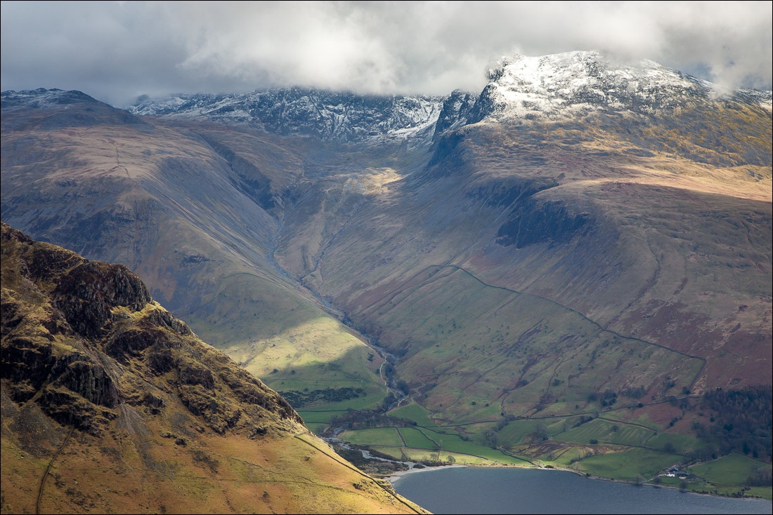
Lingmell and the Scafells with their heads in the clouds

Looking back to Greendale

The Scafells again

Bonnie

We continue to follow the path beside the gill

Looking back

One of the many small cascades as the gill tumbles down to Wast Water…

…and this is where it tumbles from - Greendale Tarn

We follow a faint path above the tarn - this is looking back

Part of the landscape in these parts - herdies

Shortly after the tarn we turn right to head up to the summit ridge of Middle Fell

Great Gable in the background

Seatallan

The path leading up to Middle Fell

The Scafells

…and again, with the crags of Yewbarrow in the foreground

Yewbarrow

Summit cairn on Middle Fell

Looking towards the coast

Head of Wastwater and Lingmell Gill

…and again

Another trio of herdies on the way down from the summit

Buckbarrow

As we descend we are treated to spectacular views of the Wasdale Screes, best seen from Middle Fell…

The screes are an area of loose stones and boulders under Illgill Head and Whin Rigg


Awesome

Greendale and the foot of Wastwater below

The descent path rejoins Greendale Gill

Greendale and Nether Wasdale

We retrace our steps back to the start, admiring the views towards the Scafells as we descend

We can’t resist stopping the car just beyond Greendale to admire the classic view along Wastwater again
