
Route: Goatfell
Area: Scotland, Isle of Arran
Date of walk: 21st October 2021
Walkers: Andrew, Gilly and James
Distance: 7.5 miles
Ascent: 2,900 feet
Weather: Sunshine and blue skies most of the time, one brief shower
Goatfell or Goat Fell (the former is preferred by locals) is the highest mountain on Arran and stands at a height of 2,867 feet or 874 metres. This has been the number one walk on our wish list since we arrived on the island six days ago, but low cloud and rain have ruled it out – until today, our last day here
We made an early start and parked in the Cladach Visitor Centre near Brodick. We passed by the Arran Brewery and started the long climb, which is initially through woodland and then across heather moorland, accompanied by various tributaries of the Cnocan Burn. The summit of Goatfell came into view at an early stage in the walk, and from then on it was never out of sight. There are no false summits on this route
The gradient was gentle for much of the way, but gradually increased as we climbed onto the shoulder of Meall Breac. From here the path swings more to the left, and the final push to the summit looks very intimidating seen from below. We’d read that there was some scrambling involved, so felt a little nervous about the final section. Our fears were groundless however. The final section is certainly steep, but there are no dangers and hands aren’t needed, thanks to a superbly crafted rock staircase
After a stiff climb we suddenly arrived at the small summit plateau, marked by a white trig point and a view indicator. The views over the surrounding peaks and ridges were awesome, and as an added bonus we had the place to ourselves
It’s possible to descend to Corrie from here and catch the bus back, but we were content to retrace our steps, enjoying some fabulous views over Brodick Bay along the way. It had been a wonderful walk – one of the very best – and a perfect ending to our short stay on Arran
Click on the icon below for the route map (subscribers to OS Maps can view detailed maps of the route, visualise it in aerial 3D, and download the GPX file. Non-subscribers will see a base map)

Scroll down – or click on any photo to enlarge it and you can then view as a slideshow

On the short drive to the start of the walk, we paused at the viewpoint of Cnoc na Dail to contemplate today's target - Goatfell, the highest mountain on Arran

The start of the walk from the Cladach Visitor Centre near Brodick - various signs along the way ensure that there's no chance of getting lost during the early stages

Autumn colours on the initial section through woodland

Goatfell comes into view, and remains in sight for most of the ascent

We cross this footbridge over one of the burns flowing down from the mountain

We aim for the ridge to the right of the photo, and will then turn left along it

Looking back to Brodick Bay, with Holy Island beyond

James contemplates the way ahead as we approach the ridge

Looking across to Coire Nam Meann

We arrive at the foot of the ascent ridge - the going gets tougher from here...


James climbs the rocky staircase


Looking back along our ascent ridge and the alternative ascent via Meall Breac to the left

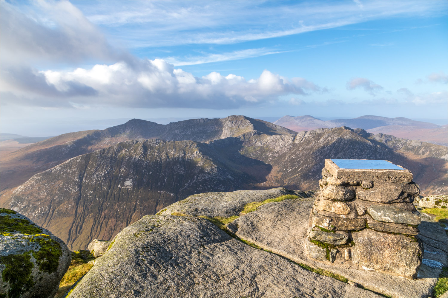
We reach the summit of Goatfell, marked with an OS trig point and a stone cairn with a view indicator


A wonderful view over the northern mountains of Arran...


Panorama (depending on your device, it may need a click for a bigger view)

James admires the view


Looking out to sea, with Holy Island right of picture

It was very cold and windy up there and time to start the descent by retracing our steps

Brodick Bay and Holy Island

Descending towards miles of open moorland

A hazy view of the Scottish mainland in the distance

Brodick Bay and Holy Island again

Looking back along the ridge to the summit

We were glad to have made an early start as clouds rolled in at this point, bringing a passing shower

After a long walk across the moorland, Brodick Bay comes into view...


We follow the track through the final woodland section to the end of a memorable walk

On the way back to our base we stopped the car at Brodick for a final glance back up to Goatfell

Our last day here, and a rainbow over Holy Island seen from our rented cottage in Lamlash

Souvenirs

Early next morning, farewell to Arran from the ferry, and the end of a wonderful week's walking
Follow the link for more walks in Scotland (44)
