
Route: Low Fell
Area: Western Lake District
Date of walk: 2nd January 2023
Walkers: Andrew, Gilly and James
Distance: 4.5 miles
Ascent: 1,500 feet
Weather: Sunny
Low Fell is one of our traditional walks on New Year’s Day, but we ruled it out yesterday thanks to heavy rain, low cloud and strong winds. Today brought a long awaited improvement in the weather and without ado we set off to the start point. Low Fell is one of my favourite places and the fell which I chose for my 1,000th Wainwright ascent in May 2018.
The upland section of Low Fell is heathland which has been grazed by sheep for many years and in consequence lacks biodiversity. A large portion of the fell, some 158 acres, has recently been acquired by Buy Land Plant Trees Community Interest Company and is now part of a project to restore the natural ecosystem. Follow the link for more information about this very worthwhile endeavour
We parked as usual in one of the few roadside spaces outside the small settlement of Thackthwaite on the west side of Lorton Vale. We walked into the village and turned right at a signpost next to Thackthwaite Farm and followed a rocky lane uphill. This leads out onto the fields and from here we followed a line of old oak trees up to the intake wall. There are lovely retrospective views from here.
On reaching the intake wall we turned right to follow a grassy path which curves around the fellside into a small raised valley, where the views are lost – this is a rather dreary section in truth, but it’s soon over and before long we were on the ridge line, heading south with ever improving views along the way
Anyone visiting Low Fell for the first time should not stop at the north top, but should continue to the very end of the ridge where there is a cairn just below the south top. From here, in the words of Alfred Wainwright, ‘the view is of classical beauty, an inspired and inspiring vision of loveliness…a scene of lakes and mountains arranged to perfection’
Having savoured the heavenly scene for a while we retraced our steps back to the start, which takes around an hour
For a longer route, which also takes in Darling Fell and Loweswater click here and for a steep direct route descent click here
Click on the icon below for the route map (subscribers to OS Maps can view detailed maps of the route, visualise it in aerial 3D, and download the GPX file. Non-subscribers will see a base map)

Scroll down – or click on any photo to enlarge it and you can then view as a slideshow

The small hamlet of Thackthwaite at the start of the walk

After turning off the village lane at Thackthwaite Farm, we follow James as he heads for the Low Fell ridge

Looking back to Lorton Vale

Looking up to the ridge connecting Fellbarrow and Low Fell

Views back to Lorton Vale

Snow covered Skiddaw in the distance

Lorton Vale and Crummock Water as we gain the ridge leading to Low Fell

Whiteside and Grasmoor

Small cairn on the north top of Low Fell, looking towards the Irish Sea. Although this is the highest point of the fell, it would be a mistake to turn back here

We continue along the ridge towards the south top

Crummock Water and the western fells

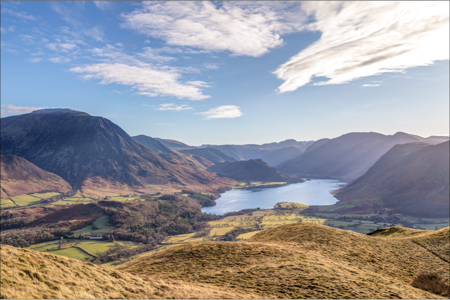
South top of Low Fell, but the best view lies from a point below the cairn....

...the sublime view of Crummock Water and the western fells (for a wider view see the video at the end)

Loweswater, and the Irish Sea beyond

Whiteside and Grasmoor again

We retrace our steps to the cairn on the south top

For anyone preferring a longer walk, it's possible to descend and re-ascend to Darling Fell (mid-picture) and return via Loweswater but we didn't have time for that today

We were content to retrace our steps and enjoy the glorious views for a second time

Lorton Vale

The Solway Firth and the coast of Scotland in the distance

Views of Lorton Vale as we retrace our steps...


Looking west to the Irish Sea

Zooming in on Skiddaw

We descend gently back into Lorton Vale...


Looking over Redhow Wood to Whiteside

Back to the start, and a last look across Lorton Vale to Lorton Dodd and Whiteside
Memories of the view from the south end of Low Fell
