
Route: Low Fell
Area: Western Lake District
Date of walk: 7th June 2019
Walkers: Andrew
Distance: 4.6 miles
Ascent: 1,400 feet
Weather: Sun and blue sky at first but pale white skies gradually coming in
Today’s visit to Low Fell would make it my 41st. What Low Fell lacks in stature it more than makes up for with the magnificent view from its southern top. This is one of my favourite places in the district
I parked as usual in one of the few roadside spaces outside the little village of Thackthwaite. I walked into the village and turned right at a signpost between the houses, following the rocky lane uphill. The leads out onto the fields and from here I followed a line of old oak trees up to the intake wall
On reaching the intake wall I turned right to follow a grassy path which curves around the fellside into a small raised valley, a rather dreary section in truth, but it’s soon over and before long I arrived on the ridge line, heading south
The views from the ridge get better and better, and anyone visiting Low Fell for the first time should not stop at the north top, but should continue to the very end of the ridge where there is a cairn just below the south top. From here, in the words of Alfred Wainwright, ‘the view is of classical beauty, an inspired and inspiring vision of loveliness…a scene of lakes and mountains arranged to perfection’. By now the weather, so promising at first, had deteriorated, and white featureless skies detracted from the view
I had intended to descend via Darling Fell to Loweswater, but in view of the poor light decided instead to take a shorter route back. I retraced my steps for a short distance and followed the very steep path down beside a fence. There are good views on the descent, but it’s hard to enjoy them from such a steep gradient. Lower down, the path leaves the line of the fence and traverses across the fellside through the bracken. It’s reasonably well trodden and easy to follow. On the last occasion I descended this way I followed the public footpath to Foulsyke and returned along the road. Today I took a new route along a path which isn’t shown on the OS map, but is clearly there on the ground. It’s quite faint but easy to follow and runs just above the intake wall (or what’s left of it). This brought me back to the path above Thackthwaite, and from here I retraced my steps back to the start
For other walks here, visit my Find Walks page and enter the name in the ‘Search site’ box
Click on the icon below for the route map (subscribers to OS Maps can view detailed maps of the route, visualise it in aerial 3D, and download the GPX file. Non-subscribers will see a base map)

Scroll down – or click on any photo to enlarge it and you can then view as a slideshow

An unusual garden visitor yesterday - a hare

The village of Thackthwaite at the start of today's walk

I leave the road at Thackthwaite House to walk up a rocky lane

Looking towards Lorton

I follow a line of oak trees uphill - the Low Fell ridge is beyond. I spotted a young grey squirrel here - bad news in a red squirrel area (I've since reported this to the local red squirrel volunteer group)

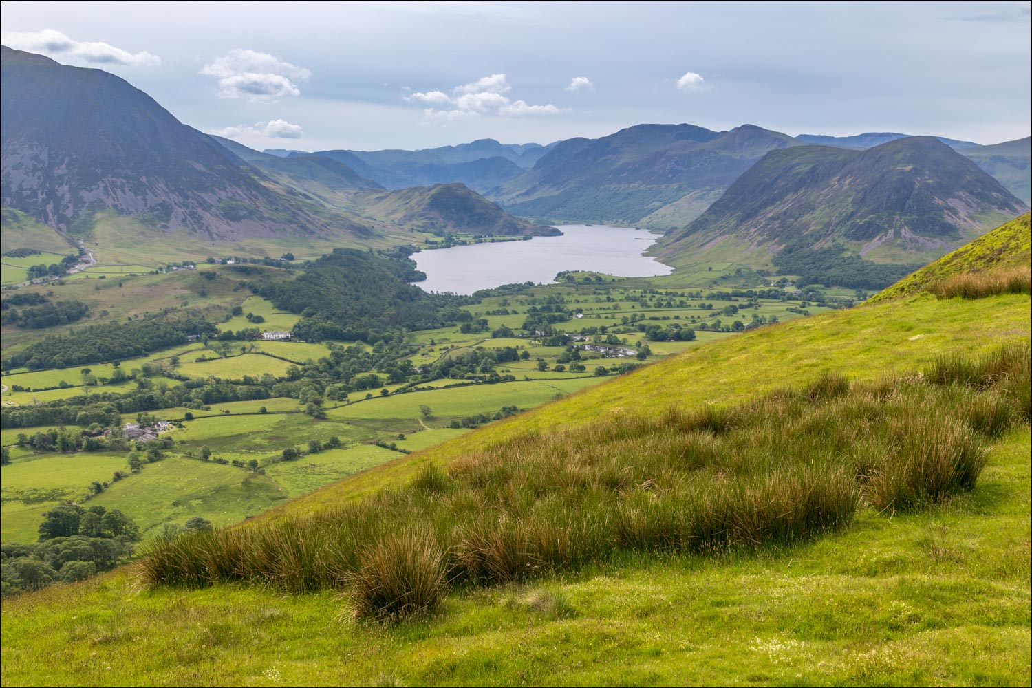
A staircase consisting of Lanthwaite Hill, Rannerdale Knotts, Haystacks and Great Gable at the top

Inquisitive lambs

Looking back across Lorton Vale

The path heads towards Fellbarrow for a short distance

A view back to Crummock Water - the pallid sky is gradually coming this way, and spoils the light looking south

Fellbarrow on the right

Looking back to Lorton


Another view back, with the hills of Scotland just visible in the distance

I arrive on the summit ridge and follow the undulating path along it

Views over Lorton Vale as I continue along the ridge...


Crummock Water...


I head towards the north top of Low Fell

Small cairn on the north top, looking across the Solway Firth to Scotland

A down and an up to the south top

South top of Low Fell

The best view is from a point below the south top, but the light is very uninspiring. I've often lingered here, but not today

Loweswater and Holme Wood

Looking into lonely Mosedale

The start of an initially very steep descent - the wire fencing is a useful aid on this section

Whiteside and Grasmoor as the gradient eases

Looking across to Crummock Water

The path beside the fence stops at a particularly steep section, and now traverses across the fellside, descending to the line of trees below

As I approached the intake wall, I spotted a butterfly I've not seen before - a rare Marsh Fritillary, which is on the endangered list

Looking across Lorton Vale as I follow a path above the intake wall

A view back to Crummock Water

Kirk Fell and Graystones above Lorton

A wheatear on the fence

Lorton Vale again

I pass through a small coppice - my camera is horizontal, the trees aren't

I arrive back at a gate which I'd passed through earlier. The circuit is complete and it just remains to retrace my steps

Back in Thackthwaite, I keep a sharp lookout for delinquent squirrels as I return to the start

Next morning, I was happy to see a red squirrel in the garden after a worrying 2 month absence
