
Route: Low Fell and Darling Fell
Area: Western Lake District
Date of walk: 27th February 2020
Walkers: Andrew and Gilly
Distance: 3.8 miles
Ascent: 1,400 feet
Weather: Mostly sunny, windy and bitterly cold on the tops
Low Fell is one of our favourites in the district, and we’ve been up here many times (40 to be exact). We parked as usual in the small layby just outside Thackthwaite. After walking into the village we turned right to follow the signed path uphill. There are good views back over Lorton Vale during this early section of the walk
We soon arrived on the undulating ridge of Low Fell. The views from here are wonderful all the way along, but the very best vantage point is at the furthest end. Anyone who turns back when reaching the north summit cairn is missing the whole point of the walk. The view from the cairn just below the south summit is described by Wainwright as a ‘view of classical beauty, an inspired and inspiring vision of loveliness…..a scene of lakes and mountains arranged to perfection’. We could never tire of this scene and lingered here for a while taking in the view. It was bitterly cold though and Gilly decided to retrace her steps. We came up with a plan which would enable me to continue the walk by visiting nearby Darling Fell, and Gilly would pick me up on the Loweswater road
Darling Fell is not a Wainwright although in some ways it deserves to be, as the views from here rival those from Low Fell. However, it’s a steep descent and an energy sapping ascent before they can be enjoyed. From here I descended west, with views of the Irish Sea and the hills of Scotland in the distance. The public footpath marked on the OS map does not accurately record the location of the path on the ground, but there are no navigation difficulties and route finding is straightforward
I eventually arrived at the old Mosser Road and descended down it to the Loweswater road. I only had to wait a couple of minutes before Gilly arrived in the car. For anyone who prefers a circular route, it’s a very pleasant stroll back to Thackthwaite along quiet country lanes, or alternatively Loweswater could be included in the round – click here for the route
For other walks here, visit my Find Walks page and enter the name in the ‘Search site’ box
Click on the icon below for the route map (subscribers to OS Maps can view detailed maps of the route, visualise it in aerial 3D, and download the GPX file. Non-subscribers will see a base map)

Scroll down – or click on any photo to enlarge it and you can then view as a slideshow

Looking across Lorton Vale from the parking space near Thackthwaite

We walk through the quiet and unspoilt village and turn right beyond the wooden fence

The Low Fell ridge at the start of the easy climb

Looking back over Lorton Vale to Whiteside

The High Stile Range is on our left

Lanthwaite Hill in the foreground, the subject of a walk earlier in the week

High Lorton and Kirk Fell

Looking back to Crummock Water

The slopes of Fellbarrow on the right

Ours are the only footprints in the snow as we look back to High Lorton

We pass by an inquisitive flock of Herdwick sheep

A hint of things to come, with Rannerdale Knotts in the centre of the picture and blinding sunlight on Crummock Water

We gain the long summit ridge and head south along it...


Looking down into sweet Lorton Vale after crossing a stile

Looking along the ridge from the north top of Low Fell, but anyone who turns back here is missing the whole point of the walk

Further along the ridge

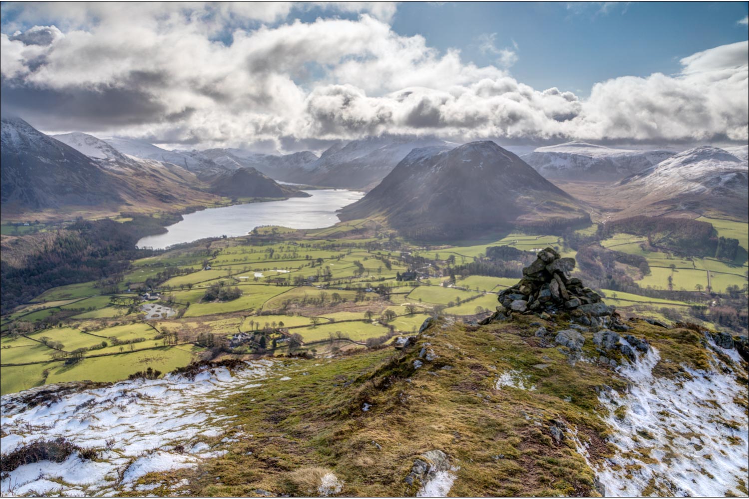
The south top of Low Fell, but for the best view it's necessary to continue for a few more yards

Loweswater below

Hen Comb, with the lonely valley of Mosedale on the left

Whiteside and Grasmoor

We descend from the southern cairn to a lower cairn - the views from here are superlative

Crummock Water and Mellbreak

Loweswater and its fells

Panorama from Low Fell (click to view)

Constantly changing light as the focus shifts back to Loweswater

I can't resist a final photo - it was bitterly cold up here, so at this point Gilly retraces her steps to the start, and I set off for Darling Fell - we'll meet up in an hour if all goes to plan

Darling Fell - I have to surrender a lot of height, only to have to regain it

Crabtree Beck at the hause between Low Fell and Darling Fell

Summit of Darling Fell

Low Fell from Darling Fell, with Whiteside and Grasmoor in the background

Looking back to the summit as I start the easy descent

I pass over this stile, which is presently redundant

Loweswater below, and the Irish Sea in the distance

The landscape changes as I head towards the edge of the Lake District - the hills of Scotland are just visible in the background

Lovely light on Loweswater on my left

Askill Knott ahead, but before reaching it the path curves round towards Loweswater...


I arrive at the old Mosser Road and descend along it

The Loweswater road, and a couple of minutes later Gilly arrived - our cunning plan had worked, and we celebrated its success at the nearby Kirkstile Inn
