
Route: Holme Wood and Loweswater
Area : Western Lake District
Date of walk: 7th November 2025
Walkers: Andrew and Gilly
Distance: 4.3 miles
Ascent: 600 feet
Weather: Cloudy with bright intervals
Today’s walk was a slightly longer version of our walk to Loweswater from Fangs Brow earlier this year. Fangs Brow is set in an elevated and quite remote position on the western edge of the Lake District. There are several roadside parking spaces at the start of the walk. We followed the obvious track, signposted for Loweswater, and set off along open moorland. As on the last occasion, we followed the route in an anti-clockwise direction in order to keep the best views ahead as we walked. The track is known as the Old Coffin Road from Loweswater to St Bees (the description is probably fanciful but the name has stuck)
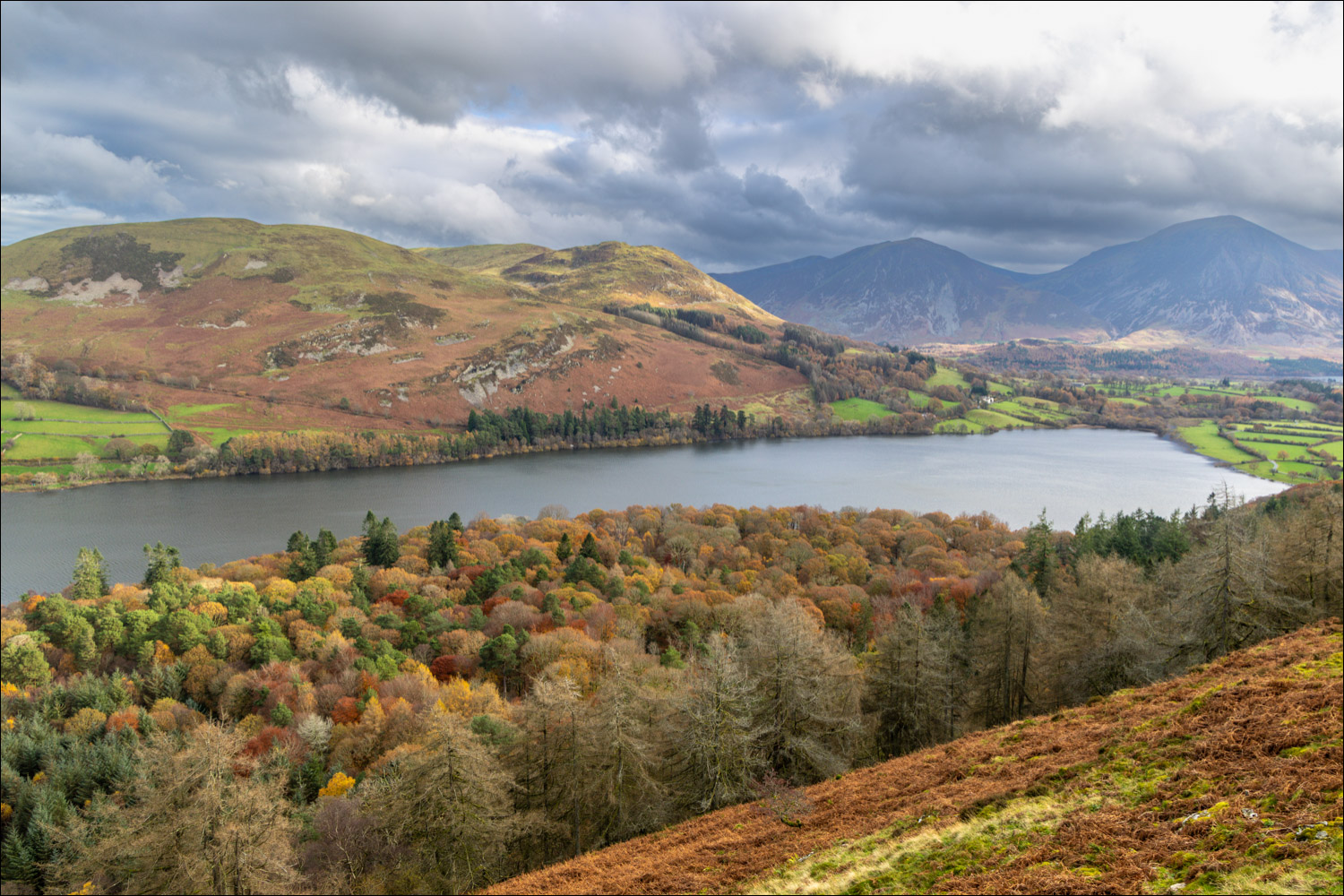
Before long Loweswater appeared. The views become better and better on the approach to Holme Wood, and from a well positioned bench along the way there’s a superlative view over Loweswater to Crummock Water. We were fortunate that a few patches of sunlight illuminated the wonderful autumn colours in the woodland below
We continued along the terraced path, which involves a few ups and downs, until we came to a gate leading into Holme Wood, owned by the National Trust. We followed a slanting path down through the wood. Sadly the National Trust has been obliged to carry out forestry operations here by felling all larch trees within 100m of a tree infected by the disease Phytophthora ramorum. Larch made up 75 per cent of the woodland and so the felling has been quite extensive, especially in the upper parts of the woodland. Nature will heal the wounds in due course, but the initial part of the descent is through a recently felled area. On the positive side this has opened up new views over Loweswater and the fells around it
We turned left at a junction in order to visit Holme Force. The waterfall was in good form following recent heavy rain. The path eventually brought us down to the head of Loweswater (the lake is unusual as it drains into lakeland rather than away from it as would be expected). It seemed a shame to leave Holme Wood when the autumn colours were at their best, so we walked back into the wood and around the shore of Loweswater. We left Holme Wood and followed a path through fields above Jenkinson Place as far as Iredale Place, where we turned left to walk uphill. The path brought us back to the old coffin road and from here we retraced our steps back to the start
For other walks here, visit my Find Walks page and enter the name in the ‘Search site’ box
Click on the icon below for the route map (subscribers to OS Maps can view detailed maps of the route, visualise it in aerial 3D, and download the GPX file. Non-subscribers will see a base map)

Scroll down – or click on any photo to enlarge it and you can then view as a slideshow

The start of the walk from Fangs Brow as we head into lakeland

We pass by a herd of belted galloway, which often graze these pastures

We will return via the gate on our left and continue ahead following the sign for High Nook

We are in the far north of the Lake District, illustrated by these photos looking back over the Solway Firth to Criffel in Scotland...


Further along the path, the head of Loweswater comes into view

The terraced path known as the Old Coffin Road, which contours around the flanks of Burnbank Fell and offers wonderful views beyond this corner...

Loweswater and Crummock Water

Autumn colours in Holme Wood below...

Our path will take us through Holme Wood shortly

One of the best positioned benches in all of lakeland, where we sat and gazed for a while

We continue along the Old Coffin Road, looking across to Darling Fell, Low Fell, Whiteside and Grasmoor beyond Loweswater

Looking back over Holme Wood to the head of Loweswater

Windswept trees at the edge of Holme Wood as we head into a gully created by Holme Beck

The Old Coffin Road continues to High Nook, but we leave it here and fork left into Holme Wood

Looking back to the Old Coffin Road

We enter into Holme Wood and descend along a slanting path

Many of the trees in the upper part of the wood have been felled in order to prevent the spread of ramorum, or larch tree disease

Whiteside and Grasmoor

We take the first junction on our left in order to visit Holme Force

Autumn colours in Holme Wood as we descend towards Loweswater...


We wanted to make the most of the autumn colours, so we made a short diversion into Holme Wood and crossed a footbridge over Holme Beck

View along Loweswater, looking towards Grasmoor

We pass by the bothy, available to rent from the National Trust

We follow the lakeshore path - the levels are high due to incessant rain for several days

Grasmoor

Walking out of Holme Wood

Looking across to Loweswater

Views back to Loweswater as we start the gentle climb up to Fangs Brow...


We follow the sign to Fangs Brow and join a path leading past Hudson Place

Looking back to Loweswater

Just before Iredale Place we fork off to the left

Iredale Place below

We cross the stile and turn right. This completes the circuit and from here it's a short stroll back to the start
