
Route: Around Hackness
Area: North Yorkshire
Date of walk: 7th April 2021
Walkers: Andrew and Gilly
Distance: 2.7 miles
Ascent: 300 feet
Weather: Mostly cloudy with a few sunny spells
Hackness is a small and unspoilt village near Scarborough and is located in the North York Moors National Park. Numerous walking routes radiate out of the village in all directions. We’ve not been able to visit Hackness for several months due to lockdown restrictions, so it was good to be back. We decided to celebrate the occasion by repeating a short walk we last did in October, and which is one of our favourites
We startd from Derwent View holiday cottage, but anyone not staying at the cottage could start just as easily from the nearby village hall. After walking along the village street we turned right at the war memorial by the village hall, and just beyond Mill Farm we left the road to climb up to a path which hugs the edge of Walker Flat Wood. There are lovely views back over the valley from here
The path leads into the woodland briefly before emerging above St Peter’s Church and Hackness Hall. The hall and its landscape gardens were created in the 1790s, and the house is a Grade I listed building. Neither is open to the public. The Hackness Shame is an entertaining story about an event which occurred here in 1600
Although it’s possible to leave the woodland path via an old stile, a fence has recently been erected in the field (crossing the line of a public footpath as shown on the OS map), making it easier to stay in the woodland until a second stile is reached. This emerges into the field above Hackness Hall. The view over the Hall and St Peter’s Church is superb – one of the best in the area
After passing above the hall we descended to the road and turned left, passing by the entrance to the hall. We made a short detour to St Peter’s Church and then continued along the village road. We’d normally have followed a track which branches off the road and offers good views along the valley, but the weather was indifferent by now so we continued along the village road back to Derwent View. (Note the the route map shows the former option)
For other walks here, visit my Find Walks page and enter the name in the ‘Search site’ box
Click on the icon below for the route map (subscribers to OS Maps can view detailed maps of the route, visualise it in aerial 3D, and download the GPX file. Non-subscribers will see a base map)

Scroll down – or click on any photo to enlarge it and you can then view as a slideshow

The week before the walk, some sightings in the garden - a female bullfinch

Male bullfinch

Blue tit

Robin

Goldfinch

and a fox reflected in the pond

The start of the walk from Derwent View Hackness - as mentioned in the introduction, most people would start the walk from the nearby village hall car park

We walk along Broxa Lane, passing by some attractive cottages

We pass by Hackness Village Hall

Leaving Hackness

Mill Farm

Just beyond Mill Farm we leave the road at a public footpath sign and climb uphill, here looking back to Hackness

Coomb Hill and Mount Misery

After climbing up to the edge of Walker Flat Wood we follow a path along its edge

Looking back over Mill Farm to Hackness

It used to be possible to walk along the fields but a fence now prevents that, and we cross this stile to enter Walker Flat Wood

The path hugs the edge of the wood

At a second stile we leave the wood to enter onto grazing land

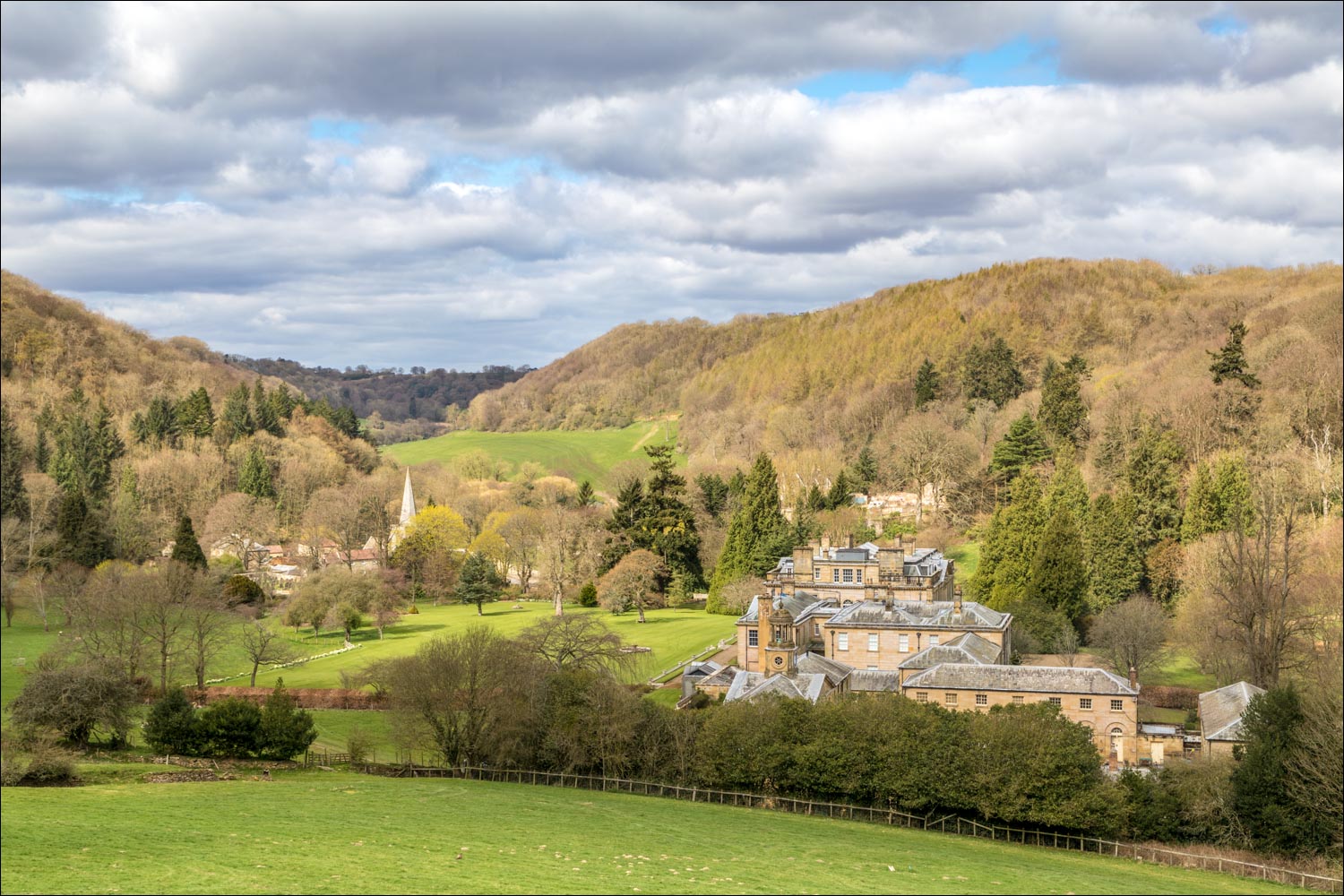
Hackness Hall

Views looking back along the valley....


The path continues above Hackness Hall, but I lingered here for a few minutes in the hope of better light...

...and this is why - the lovely view over the Hall

St Peter's Church, which we'll be visiting shortly

Looking along Lowdales

The path descends to the road

The view on our left as we continue downhill

Looking back

We cross the stile and head down to the road

A final view over the Hall and the Church

Having reached the road, we follow it past the entrance to Hackness Hall

We pass under a bridge which connects the Hall to another part of the estate

St Peter's Church

Inside the church grounds...


We return to the road and follow it back to the start - an alternative route shown on the maps page follows the track on the right
Follow the link for more walks in North Yorkshire (152)
