
Route: Brackenthwaite Hows
Area: Western Lake District
Date of walk: 19th October 2018
Walkers: Andrew
Distance: 2.1 miles
Ascent: 400 feet
Weather: Cloudy with some sunny patches
Brackenthwaite Hows, otherwise known as Lanthwaite Hill, is one of my favourite places in the Lake District. This walk has featured on my site many times, but I take the view that no two walks are ever the same – changing seasons and variations in the light and weather make for an infinite number of possibilities – and there’s always something new to be seen
I parked as usual in the National Trust car park at Scale Hill. Instead of taking the obvious track ahead, which leads directly to the north shore of Crummock Water, I turned left up a steepish path through Lanthwaite Wood. At a junction I turned left again to continue uphill, climbing a rocky staircase along the way
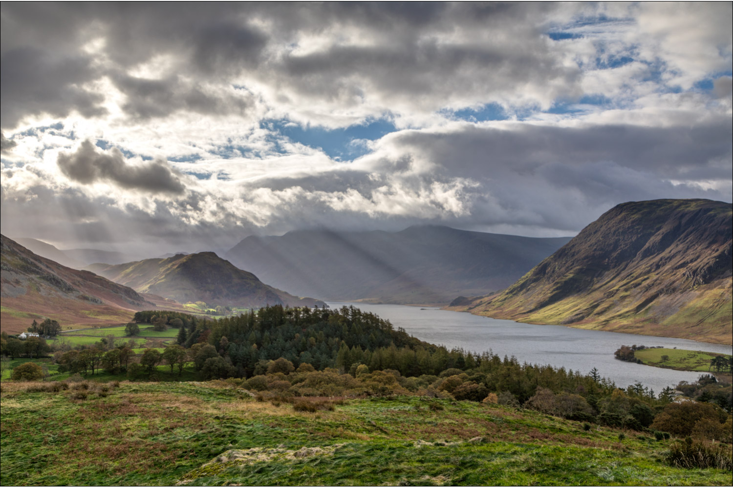
After leaving the woods via a deer gate I was soon at the top of the hill, admiring the superb views over Lorton Vale, Loweswater and Crummock Water. The light over the latter was especially dramatic, and I lingered here for a while as the clouds shifted across the sky, allowing patches of sunshine to illuminate the surrounding fells
I then followed the easy path back down into Lanthwaite Wood, following a path which hugs the edge of the woods, giving good views across to Lanthwaite Green
The path descends to the eastern shore of Crummock Water, and when I arrived at the lakeshore I followed the path to the foot of the lake, from where there were more tremendous views towards Mellbreak and Rannerdale Knotts. From this point there are two ways back to the start – a path which follows the bank of the River Cocker, and the wide track leading through Lanthwaite Wood. I opted for the track today, and 5 minutes later I was back to the car park to end a short but very sweet walk
For other walks here, visit my Find Walks page and enter the name in the ‘Search site’ box
Click on the icon below for the route map (subscribers to OS Maps can view detailed maps of the route, visualise it in aerial 3D, and download the GPX file. Non-subscribers will see a base map)

Scroll down – or click on any photo to enlarge it and you can then view as a slideshow

A view of Mellbreak across the River Cocker from the car park at Scale Hill

The start of the walk - I'll be returning via the track ahead and turn sharp left here to climb up a narrow path

Through the trees, I spot the 'Loweswater Pheasant' - Holme Wood on Carling Knott

I pass through the deer gate and exit Lanthwaite Wood

A view back along the path, looking towards Loweswater, as I approach the top of the hill

From Brackenthwaite Hows, a view north over Lorton Vale

Shafts of sunlight over Rannerdale Knotts

Loweswater and its pheasant again

Mellbreak and Crummock Water...

Constantly changing light from the top of Brackenthwaite Hows - this is Rannerdale Knotts again above Lanthwaite Wood

A wider view

Lanthwaite Green

I start to descend from the hill in the direction of Rannerdale Knotts and Lanthwaite Wood

I enter the wood once more

I follow a path which skirts around the edge of the wood, here looking towards the lower part of Grasmoor

Lanthwaite Green


The path joins a stream, which I follow downhill to the shore of Crummock Water

The boathouse on the east shore

Looking across Crummock Water to the foot of Mellbreak

I follow the track along the shore to the foot of the lake...


At a line of pine trees I leave the track and descend to the foot of Crummock Water

If this old pine tree could speak, it would be saying 'Just look at that'

Looking back to the boathouse which I'd passed earlier

Views of Mellbreak...


The boathouse again

I tear myself away from those views and follow the wide track back to the car park to end the walk - one which I've done many times and could never tire of

A few minutes later, a view across Lorton Vale to the toe of Low Fell, and Carling Knott beyond

[…] fashion. It has now come to be regarded as a hidden gem. Known and loved by local dog walkers and intrepid ramblers armed with an OS map, it has been largely ignored by tourists, who prefer to scale famous peaks […]