
Route: High Gait Crags
Area: Southern Lake District
Date of walk: 18th October 2018
Walkers: Andrew
Distance: 9.6 miles
Ascent: 2,000 feet
Weather: Sunny, gradually clouding over later on
For the second day in succession I drove to the remote valley of Eskdale. The weather was fine, and I’d been saving this walk for a day such as this. My target was High Gait Crags, a little known fell and one I’ve not climbed before. It’s not a Wainwright as it doesn’t fulfil his criteria for an independent fell, although it boasts a respectable height of 1.700 feet. The great glory of the fell is its situation, set below some of lakeland’s highest and most dramatic views, and allowing close up views of them
I parked in a small car parking space at the foot of the Hardknott Pass and after walking a few yards back down the road turned right at a dilapidated red phone box. I followed a path beside the River Esk which rose easily up the valley to Lingcove Bridge. After crossing the bridge I followed a faint path which soon disappeared. In the absence of a path I used the prominent rock feature of Pianet Knott to guide me in the right direction, then climbed past Long Crag and Low Gait Crags to my objective, High Gait Crags. This was an wonderful place, and must be one of the finest locations in lakeland. I spent 30 minutes or so gazing in awe at the magnificent mountain scenery all around me, including Scafell Pike, Scafell, Bowfell, the Crinkles and many more besides
All too soon it was time to start the descent and I plotted a course in the direction of the infant River Esk. There was no path, but the direction of travel was fairly obvious. After recent heavy rain I had my doubts about being able to ford the river, and had to divert a little way upstream before a suitable opportunity presented itself. Walking poles were a great help in maintaining balance as I teetered across the slippery rocks. Having made it to the other bank I found a faint path beside the river but it soon became too boggy, so I headed uphill and found an alternative one. It was a long descent back down the valley, but eventually the green fields of Eskdale came into view. I made my way down to Taw House, turning left just before it, and from here it was a short stroll back to the start
It had been one of the finest lakeland walks I’ve ever experienced, and in the 5 hours it took I hardly saw another soul, just a few fellow walkers near the start and finish
Click on the icon below for the route map (subscribers to OS Maps can view detailed maps of the route, visualise it in aerial 3D, and download the GPX file. Non-subscribers will see a base map)

Scroll down – or click on any photo to enlarge it and you can then view as a slideshow

On the way to the south of the district there was some magical early morning mist, so I made a short diversion to Crummock Water...

...Woodhouse Islands at the head of the lake

I then drove past Loweswater and another diversion proved to be irresistible

This is the path to the foot of the lake

Now at the head of Loweswater, a golden silver birch


Looking towards Low Fell. It was tempting to stay and enjoy the conditions, but I had a long walk planned and it would take me over an hour to get to the start - time to be setting off

An hour later, the start of the walk from the foot of the Hardknott Pass. I take the track to Brotherilkeld Farm and bear left just before it to follow a path beside the River Esk

Bowfell in the distance

Heron Crag on my left as I continue up the valley

I arrive at the intake wall

I pass by a series of waterfalls in the River Esk...


I cross Lingcove Bridge. Up to now I'd seen 4 or 5 other walkers but from this point I didn't see another soul until the end of the walk

Beyond the bridge I leave the bank of the River Esk and keep Lingcove Beck to my right

A crystal clear pool in Lingcove Beck

Even though a path is shown on the OS map, it doesn't really exist on the ground and I try to find the easiest way uphill. The lump of Pianet Knott ahead is a useful guide and I aim for the hause to its left

Bowfell left and Long Top on Crinkle Crags right

The hause between Pianet Knott and Long Crag is just ahead

Long Top on Crinkle Crags again as I pick up a faint path beyond the hause

A glimpse of Esk Pike left, and Bowfell on the right

Looking back to Eskdale, with Hardknott on the left

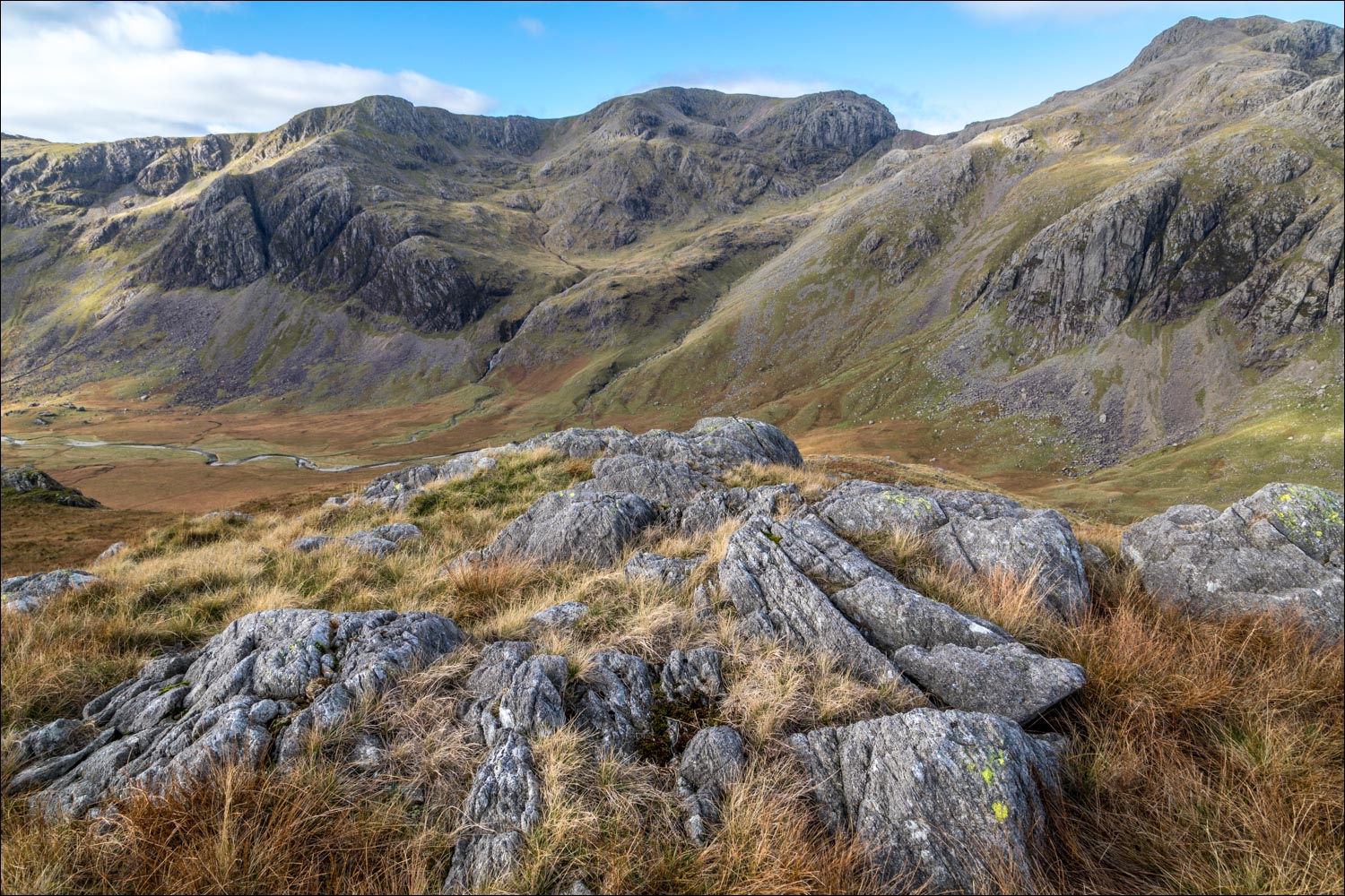
High Gait Crags on the right - not far to go now

Bowfell again...

...and Crinkle Crags

I feel lucky to have the best seat in the house as I gaze at the mountain scenery from the summit of High Gait Crags. This is Scafell Pike and Ill Crag...

...Scafell and Scafell Pike, with Symonds Knott between them

The small summit cairn, looking towards Bowfell and Crinkle Crags

Slight Side - and my return route below, on the far side of the River Esk. I can just make out the Irish Sea in the distance

Bowfell

Scafell

Zooming in on Scafell Pike and Rough Crag below it...

Close ups of some of the spectacular rock scenery - it was a privilege to have been here on a day like this...

...but all good things come to an end and I start the pathless descent from High Gait Crags in the direction of Scafell Pike

I detour to a small unnamed tarn...

I'm aiming for the River Esk, but need to head upstream in order to avoid the squelchy morass of Great Moss below the crags of Scafell

Herdies

Great Moss and the River Esk

I arrive at the River Esk and after walking upstream find a suitable place to ford it

Cam Spout

Looking back up to Esk Hause

A herdy beneath one of the many huge boulders which have tumbled down from the mountainside

I pass through an old sheepfold

Looking back along the Esk...

...and now looking downstream - I'm following a higher path in order to avoid Great Moss

Looking back to Bowfell above High Gait Crags and Low Gait Crags

Harter Fell ahead

Another view back to High Gait Crags

The rampart of Yew Crags above Eskdale

I make my way down into Eskdale, aiming for Brotherilkeld Farm on the right...


Beyond the farm I retrace my steps along the track to the end of a walk which will live long in the memory
