
Route: Sale Fell
Area: North Western Lake District
Date of walk: 2nd January 2019
Walkers: Andrew and Gilly
Distance: 3.1 miles
Ascent: 800 feet
Weather: Sunny, clouding over at the end. Very cold
Standing at a height of 1,170 feet, Sale Fell is one of the lowest lakeland fells as classified by Wainwright, and is also one of the easiest to climb. This makes it a good choice for a walk during the short days of winter. Another bonus of the fell is that it is situated at the very edge of the Lake District and is therefore relatively quiet. Some of the more popular fells are best avoided during holiday periods such as this
We parked by St Margaret’s Church Wythop and followed the public footpath sign at the entrance gate. The path took us through the church grounds, and we exited them via a gate at the rear.
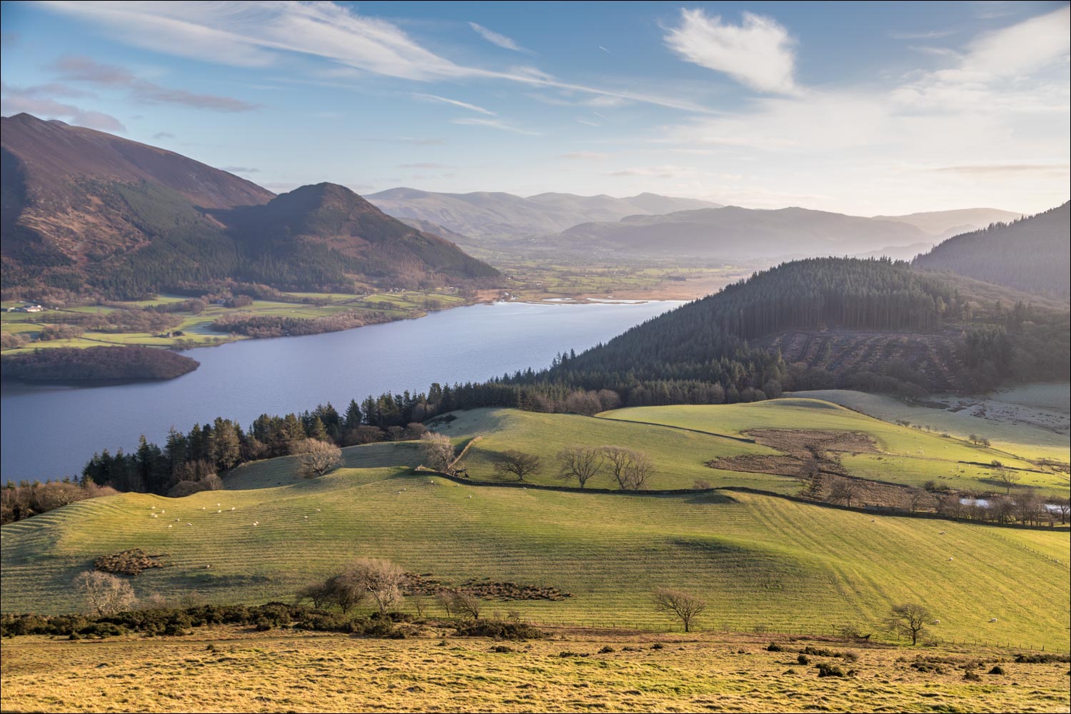
The gentle climb started immediately and before long there were some good views of Bassenthwaite Lake. The path continued beside Wythop Woods, part of which has been felled along this section. We were keen to revisit Lothwaite and the ridge along it, as there are fabulous views from here, superior to those from Sale Fell itself. We followed the grassy path to Lothwaite and walked along the ridge towards the subsidiary hill of Rivings. The views across Bassenthwaite Lake and into the Lake District were as good as we could have hoped for
We then continued up the grassy slopes, past Rivings, to the summit of Sale Fell. The Skiddaw fells are well seen from here, but nearby Lord’s Seat conceals most of the mountains of the interior.
We started the easy descent, which continues in the same direction of travel, and followed a wide grassy path which is not shown on the OS map. This took us down the nose of the fell, where we joined a lower level path which took us back to the start of the walk
For other walks here, visit my Find Walks page and enter the name in the ‘Search site’ box
Click on the icon below for the route map (subscribers to OS Maps can view detailed maps of the route, visualise it in aerial 3D, and download the GPX file. Non-subscribers will see a base map)

Scroll down – or click on any photo to enlarge it and you can then view as a slideshow

The start of the walk as we pass through the grounds of St Margaret's Church, aiming for the fellside behind it

We join the grassy path, which is as hard as rock - the low sun doesn't reach these parts during winter

Looking back to the church

Bassenthwaite Lake comes into view

A view back down to the valley

Bassenthwaite Lake - it's midday and the sun won't get any higher, causing the land in the foreground to be frosted over

Another view back along the gently rising path - the light is rather harsh and contrasty along this section, but things will improve soon

We emerge onto open fellside

Into the sunshine now as we head up to Lothwaite

Looking back to Sale Fell - our route takes us away from the fell at first. A direct ascent is possible but this would miss out Lothwaite, the best part of the walk

Lothwaite ahead

The start of a heavenly few minutes as Gilly admires the view of Skiddaw and Ullock Pike from Lothwaite

We follow a grassy path across the top of the hill

Looking along Bassenthwaite into the heart of lakeland, with the Helvellyn range in the distance

Skiddaw, Ullock Pike and Dodd to the left

We continue along the ridge, gradually trending towards Sale Fell on our right

More of the wonderful view as we progressed....


Dodd

With some reluctance we turn towards Sale Fell

I can't resist looking back

Wythop Valley below on our left

A view back to Lothwaite and the path we'd followed, left of picture

Heading for Sale Fell

The view disappears, but Skiddaw and Ullock Pike are still visible above Lothwaite...


Summit of Sale Fell - we'd followed the ridge line in the mid distance

Looking into lakeland, with Helvellyn in the distance

Start of the descent as we pass by a rock outcrop near the summit. We'd been lucky with our timing, as the clouds began to roll in at this point

Embleton below

We follow the easy path (which isn't shown on the OS map)

Just beyond this point we will turn right to head back towards the start point

The path below Sale Fell, which gradually descends in the direction of Bassenthwaite Lake

We turn off here to retrace our steps to the nearby church at the end of the walk, taking with us long lasting memories of those wondrous views from Lothwaite
