
Route: Mellbreak
Area: Western Lake District
Date of walk: 1st June 2021
Walkers: Andrew and Gilly
Distance: 7.7 miles
Ascent: 1,800 feet
Weather: sunshine and blue skies, very warm
Our normal start for this walk is the small parking space by Church Bridge, just beyond the famous Kirkstile Inn. The area has now been blocked off by large tree stumps. I don’t know whether this is temporary or permanent, but in any event we had to plan an alternative start. The nearest place is the National Trust car park at Scale Hill. This added a little distance to the walk, but it was of no consequence. We followed the road and turned off at the lane leading to the Kirkstile, passing by our usual starting point along the way. Seen from this approach, Mellbreak looks like a pyramid and its north face appears quite formidable
Beyond Kirkgate Farm the lane becomes a stony track which leads into the isolated valley of Mosedale. We left the lane at a firebreak in the woods and started the climb up the initially grassy slopes of Mellbreak. We then arrived at the steep scree section which at times is a case of two steps up, one step down. The main gully has become very eroded and several minor paths have emerged as walkers have sought out easier ways to the top. If in doubt, it’s best to follow those paths which trend from right to left. Walking poles are useful on the steep ascent, though they become a hindrance further up where there are a couple of rocky sections. The lovely retrospective views over Loweswater and Lorton Vale gave us a good excuse to stop and rest as we toiled up the fellside in very warm weather. It’s worth mentioning that this walk should be followed in the direction described – anti-clockwise. To follow the route clockwise would involve a descent down the very steep and loose north face of Mellbreak – potentially a very unpleasant experience
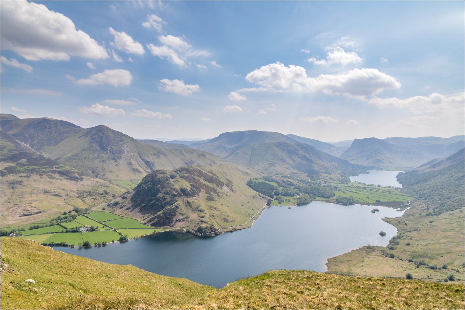
We eventually emerged at the north top and made the easy but juicy walk across the saddle to the south top ¾ mile away. The views from the ridge are restricted by its width, but there’s a wonderful feeling of isolation. Once we arrived at the south top, marked by a very insignificant cairn, the views opened up again, and the prospect over Crummock Water to Buttermere and Fleetwith Pike was glorious
We descended in the direction of Scale Force and then followed the rough path beside Scale Beck to the shore of Crummock Water. After walking along the shore of the lake, with Mellbreak towering above on the left, we left the lakeshore path near the Pump House and followed the path to Muncaster House. An alternative route would be to walk to the foot of Crummock Water and follow the path through Lanthwaite Wood. In terms of distance, there’s nothing in it but on a busy bank holiday weekend our route provided a quieter way back
For other walks here, visit my Find Walks page and enter the name in the ‘Search site’ box
Click on the icon below for the route map (subscribers to OS Maps can view detailed maps of the route, visualise it in aerial 3D, and download the GPX file. Non-subscribers will see a base map)

Scroll down – or click on any photo to enlarge it and you can then view as a slideshow

The start of the walk as we leave the car park at Scale Hill. Our target is Mellbreak, left of picture

Mellbreak, which stands aloof from other fells. We'll be ascending the steep north face and then walking along the saddleback ridge to the southern top, left of picture

We follow the sign to the Kirkstile Inn

The negative signpost by the Kirkstile Inn, where we turn right

Crossing Church Bridge over Park Beck. We'd normally have started the walk from here, but the parking spaces on the right have been blocked

The north face of Mellbreak, looking unassailable from here

We follow the path between the dry stone walls

Looking across to Grasmoor. It's still quite early in the morning, but sheep are already sheltering from the heat

Here we go - the start of a very loose and steep ascent, which gets even looser and steeper higher up

Looking back to Loweswater village and Lorton Vale

Whiteside and Crummock Water from the steepest section of the walk

'A lovely peep around a corner' as described by Alfred Wainwright in his Pictorial Guide to the Lakeland Fells

The foot of Crummock Water below

Looking back to Loweswater and Low Fell

At last the gradient eases as we approach the summit ridge

North top of Mellbreak

Looking along the saddleback shaped ridge to the south top, which is a few feet higher than the north top

Lonely Mosedale, a place so desolate that its only tree, the Mosedale Holly Tree, is named on the OS maps

A view back to the south top and to Lorton Vale as we make our way along the ridge

South top of Mellbreak

A few steps away from the south top, a view of Crummock Water and Buttermere appears

The start of the descent. Although we're aiming for the shore of Crummock Water, the path initially leads away from it, into Mosedale

Crummock Water and Buttermere...


On reaching Black Beck we turn to head towards the west shore of Crummock Water

We follow a rough path, with Scale Beck on our right


We pass by an old sheepfold, with Rannerdale Knotts in the background

On arriving at the shore of Crummock Water we turn left and head towards the foot of the lake

Looking back to Fleetwith Pike at the head of Buttermere

Whiteless Pike behind Rannerdale Knotts

We pass by a promontory known as Low Ling Crag...


Looking back

A pair of cows cooling off

Boathouse on the far shore of the lake, with Grasmoor beyond

We follow a path beside the stony beach

Grasmoor...


At this point, just before the Pump House, we leave the shore of Crummock Water (an alternative way back to the start would be to continue around the lake and walk back through Lanthwaite Wood)

We cross the bridge over Park Beck

The foot of Mellbreak on our left...

...and Grasmoor on our right

We follow the track to Muncaster House...


The Loweswater road is ahead

Scale Bridge ahead and just beyond it the end of the walk

A final glance across the fields to Mellbreak
