
Route: King’s How on Grange Fell
Area: Central Lake District
Date of walk: 4th September 2020
Walkers: Andrew
Distance: 3.5 miles
Ascent: 1,100 feet
Weather: Mixed cloud, sunshine and showers – some of them heavy
Grange How is a lowly fell but what it lacks in height it makes up for in beauty. It’s a superb craggy little fell with three separate widely scattered tops – Ether Knott, Brund Fell and today’s destination King’s How. I parked in the National Trust Bowderstone car park and from here followed a path which goes through ancient woodland, which is classified as temperate rainforest. The woodland path gradually curves around the steep crags above – a direct assault on the fell would be impossible for ordinary walkers
After walking through Cummacatta Wood I arrived at the steep (and sometimes slippery) rocky staircase which leads to Long Moss near the summit of the fell. From the summit there is a superb view over Derwent Water looking one way and Borrowdale looking the other. My arrival here coincided with a downpour, one of several
A direct descent from the summit is out of the question thanks to the crags on the west, so I followed a narrow path which snakes round the other side of the fell and which descends steeply, eventually ending at the Borrowdale road. I followed the road for a short distance – there’s a narrow footpath most of the way – then crossed over at the sign indicating the Bowderstone. I followed this path through the woods, past the massive Bowderstone and back to the car park. During the course of the walk I hadn’t seen another soul
For anyone following this walk, I’d mention that although the route is only 3.5 miles long, it is likely to take as much time as one twice its length. It’s best to set aside a full morning or afternoon. The terrain is rocky and complicated and there are very few sections where it’s possible to get into a proper stride. Walking poles are a very useful piece of kit to bring along
For other walks here, visit my Find Walks page and enter the name in the ‘Search site’ box
Click on the icon below for the route map (subscribers to OS Maps can view detailed maps of the route, visualise it in aerial 3D, and download the GPX file. Non-subscribers will see a base map)

Scroll down – or click on any photo to enlarge it and you can then view as a slideshow

The start of the walk as I pass through the gate to enter into the ancient woodland - the last surviving fragments of a huge forest that once stretched all the way down the west coast of Britain and Ireland


There are several huge boulders which have tumbled down from the crags below King's How

Looking back to Castle Crag, one of the Jaws of Borrowdale, King's How being the other

Fellside below Maiden Moor on the other side of Borrowdale

Greatend Crag on King's How, illustrating why a direct approach is not an option for walkers

The woodland looks like a rainforest, and it is

Looking across to the ridge between Maiden Moor and High Spy

I pass by another huge boulder


The crags below King's How


Grange Crags ahead, but I turn right at the dry stone wall to start the steep climb up the fellside

Start of the climb - beyond this point it's mostly steep rocky steps


A view of Skiddaw through the trees

Derwent Water comes into view higher up

The rock steps aid progress, but are slippery when wet

I arrive at a flat area, and from here it's a short climb to the summit

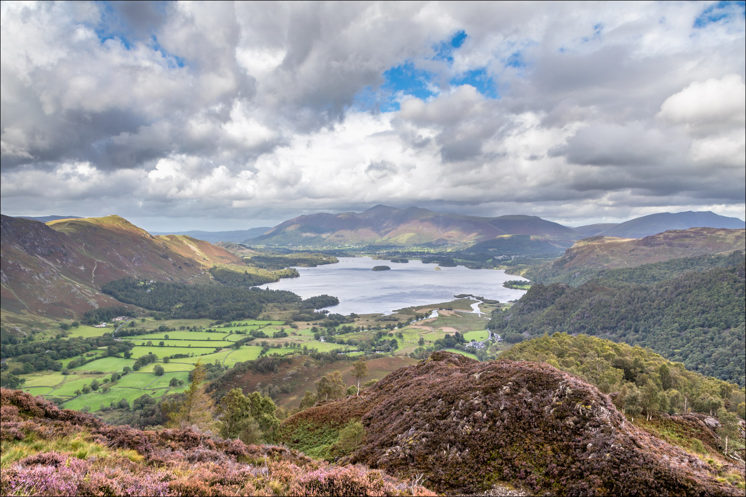
Summit of King's How on Grange Fell, looking towards Derwent Water and Skiddaw

Looking the other way into Borrowdale, with a beam of sunlight on High Doat

The complicated expanse of Grange Fell, with Brund Fell in the centre

The River Derwent below as I start the descent

Another lone tree standing like a sentinel over Borrowdale

The River Derwent again - it's easy to miss the path, which descends to the right before the gap in the wall

Rosthwaite in the heart of the valley

Sunbeam on Castle Crag

High Spy and Maiden Moor

Castle Crag again

The path descends steeply through more Borrowdale woodland

The River Derwent through a gap in the trees

A patch of sunlight on Borrowdale, looking towards High Doat

Almost down to valley level. From here there's a short road section followed by a path through the woods

Looking along the River Derwent - another downpour ensued, so this is the last of the photos. Make sure not to miss the famous Bowderstone on the path back to the car park
