
Route: Muncaster Fell
Area: Southern Lake District
Date of walk: 3rd September 2020
Walkers: Andrew
Distance: 7.1 miles
Ascent: 1,200 feet
Weather: Cloudy and overcast, brightening later on
Muncaster Fell is a long ridge in Eskdale. Its height is only 758 feet which means it can be classified as a Marilyn – a hill or mountain in Britain which has a drop of 150 metres or 492 feet on all sides. The remote location of the fell makes it a good place to get away from the crowds. During the course of 7 miles, I only saw two other walkers
I parked at The Green station, which is on the route of the Ravenglass & Eskdale Steam Railway (‘La’al Ratty’, meaning ‘little railway’). After walking along the platform I joined a path below it which took me through Bankend Wood and then through fields to Muncaster Head. I’d already decided that I’d walk the low level section first, and then return along the ridge in order to keep the views into lakeland ahead of me on the way back
Beyond Muncaster Head I joined a wide forestry track which runs below the fell, part of the Esk Trail. I made quick progress on this section of the walk. Eventually I left the track and forked uphill to start the easy ascent of Muncaster Fell. I detoured from the main path to visit the OS trig point at the summit. From here the coast and the Irish Sea may clearly be seen, although the weather was indifferent and the views weren’t at their best
I then followed an undulating path across the long ridge, a juicy affair after last night’s torrential rain. There are several paths to choose from and it doesn’t really matter which one you take, as long as you aim in the general direction of Eskdale Green. As I started on the descent, there was an improvement in the weather – better late than never. Eventually I arrived above Muncaster Head and from here I retraced my steps back to the start of an enjoyable walk
Click on the icon below for the route map (subscribers to OS Maps can view detailed maps of the route, visualise it in aerial 3D, and download the GPX file. Non-subscribers will see a base map)

Scroll down – or click on any photo to enlarge it and you can then view as a slideshow

The start of today's walk from The Green, one of the stations on the route of the Ravenglass & Eskdale Railway

At the end of the platform I join a path below on my left

Looking across Eskdale to Brantrake Crags below Birkby Fell

Beyond Muncaster Head it's an easy stroll along a wide track...


Brantrake Crags again on the far side of Eskdale

Following recent heavy rain, the River Esk has burst its banks and flooded part of the local golf course

Beyond the golf course I leave the track and join a narrow path up Chapel Hill

Muncaster Tarn - the path beside the tarn is private, and I follow another path to its right

A short woodland section, with the summit of Muncaster Fell just visible through the trees

Onto open fellside now, and here I leave the ridge path to visit Hooker Crag, the highest point on Muncaster Fell

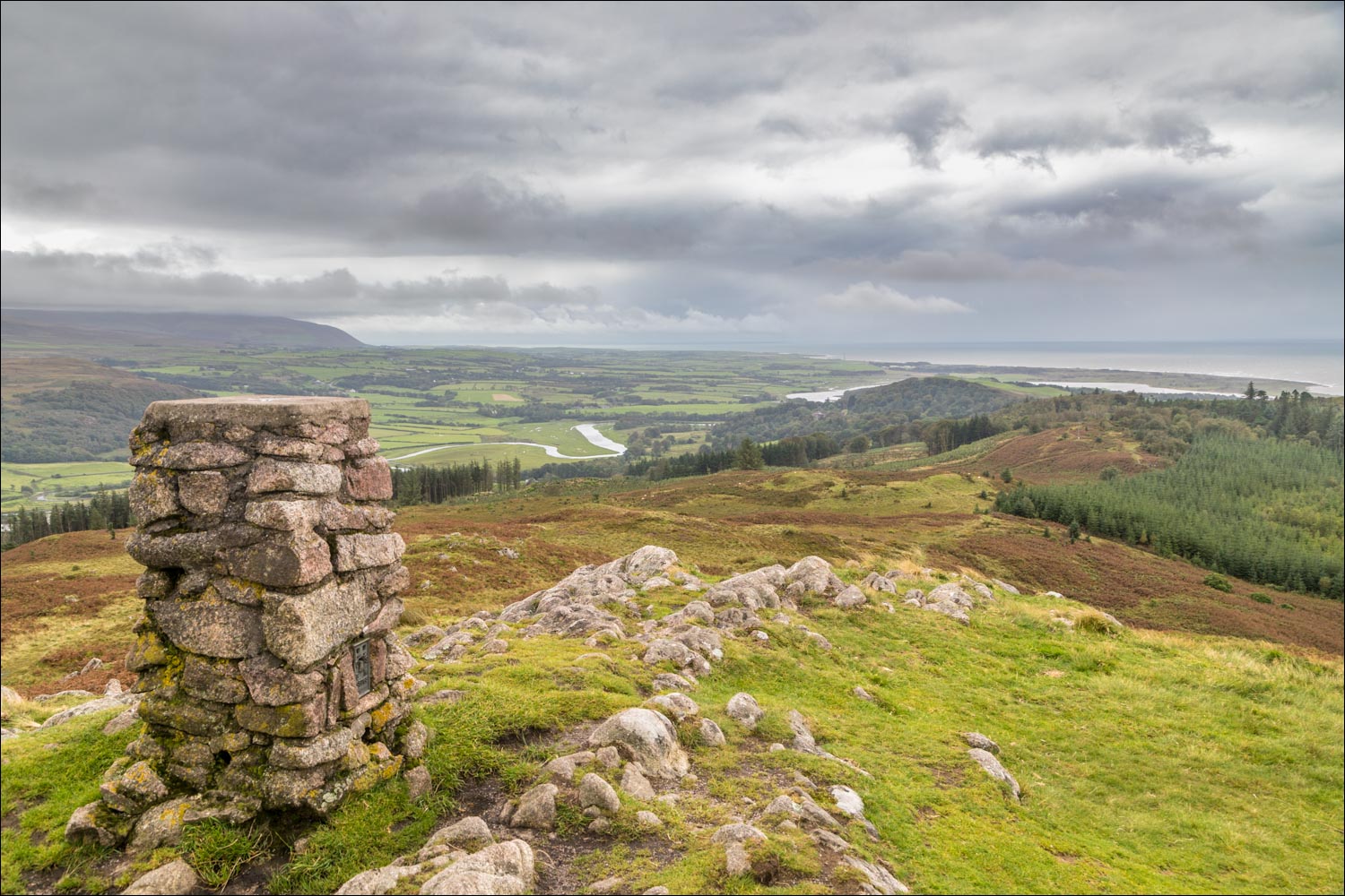
OS trig point at the summit of Muncaster Fell, looking along its ridge

The River Esk and the Irish Sea

Looking down to the flooded River Esk

I make my way along the long ridge past some (thankfully docile) cows


Eskdale

Brantrake Crags again, which I'd passed by on the low level section of the walk

On my left is Miterdale, with Whin Rigg and Illgill Head in the clouds. These two fells tumble dramatically into Wastwater on the other side

Harter Fell and the Hardknott Pass beyond the head of Eskdale

Eskdale Green comes into view...


Eskdale

I follow a path beside the dry stone wall, with views into Miterdale

I aim for the path in the centre of the picture


Eskdale below

Birkby Fell

I descend towards Muncaster Head

Brantrake Crags, as the skies finally start to clear...


Eskdale


I rejoin the original path and retrace my steps to Eskdale Green

A final look across Eskdale

Back to the start of the walk

In view of the improved light, I drove over to nearby Wastwater - these are the Wastwater Screes, Whin Rigg and Illgill Head, which I'd seen on the walk and which present a completely different character when seen from this side

Herdwick sheep below Buckbarrow...

...and a fine old oak tree

And finally the classic view along Wastwater to Wasdale Head
