
Route: Harter Fell Mardale
Area: Far Eastern Lake District
Date of walk: 29th July 2020
Walkers: Andrew
Distance: 4.9 miles
Ascent: 1,800 feet
Weather: Mixed cloud and sunshine
There are two Harter Fells in the Lake District. The subject of today’s walk was Harter Fell Mardale, in the far east of the Lake District. I was last here 6 years ago, as part of the Kentmere Horseshoe Round, so a return visit was long overdue
I parked in the car park at Mardale Head (a voluntary £2 payment is suggested). I passed through the deer gate and almost immediately turned left, following a signed path to Gatesgarth Pass. I’d previously decided to walk the route in a clockwise direction, as recommended by Alfred Wainwright, in order to keep the best views ahead of me. This proved to be excellent advice, and in turn I’d recommend anyone following this walk to do likewise
The path was easy to follow and the gradient wasn’t steep, so it was a fairly easy ascent to the top of Gatesgarth Pass. I turned right here and followed a path over Little Harter Fell, which leads to the summit of Harter Fell. There were ever improving views over Haweswater along the way. From the summit I could see a host of lakeland fells, including the Scafells in the distance. The descent route is not immediately obvious and involves leaving the line of the fence and walking in the direction of the Scafells. After a short distance the descent route to Nan Bield Pass reveals itself. It’s quite a steep and rocky descent but there are no difficulties or dangers
I was glad to have taken Wainwwright’s advice, as the views ahead of me were superb. These included four bodies of water – Kentmere Reservoir, Blea Water, Small Water and Haweswater. On reaching Nan Bield Pass I descended to Small Water and walked beside its northern shore. At the foot of the tarn I crossed Small Water Beck via the stepping stones and followed the path beside the beck back to Mardale Head
The history of Haweswater, the scenic highlight of the walk, is a long and fascinating one. To learn more about it, click here
For other walks here, visit my Find Walks page and enter the name in the ‘Search site’ box
Click on the icon below for the route map (subscribers to OS Maps can view detailed maps of the route, visualise it in aerial 3D, and download the GPX file. Non-subscribers will see a base map)

Scroll down – or click on any photo to enlarge it and you can then view as a slideshow

The start of the walk as I leave the car park at Mardale Head

Harter Fell ahead - a direct approach is out of bounds to ordinary walkers

The key to the ascent is Gatesgarth Pass, to the left of the picture

The path is set at a fairly gentle gradient

Views back to Haweswater...

Gatesgarth Beck is a constant companion on the way up

The top of Gatesgarth Pass is ahead

An important junction at the top of the pass, which can hardly be missed thanks to the sign pointing to Nan Bield Pass

The path to Harter Fell

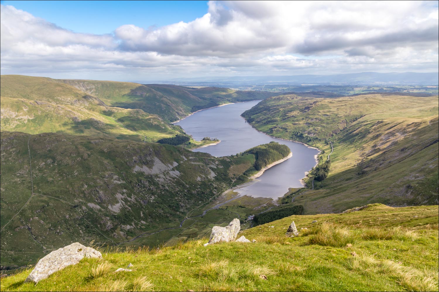
Haweswater on my right

Zooming in on The Rigg, a tree covered promontory

Looking back to Little Harter Fell - the path I'd followed to get here is on the left

Another view back along the path

Haweswater on my right as I continue along the ridge

Harter Fell ahead

Summit cairn on Harter Fell, and Scafell Pike in the distance right of picture

Ill Bell and Froswick at the start of the descent to Nan Bield Pass

It's a rough path, with some steepish sections but with no difficulties

Small Water below - my route will take me around the far shore of the tarn

Ill Bell above Kentmere Reservoir

Ill Bell and Froswick

Small Water and Haweswater again

Kentmere Reservoir...


Small Water and Haweswater again, as I reach Nan Bield Pass

Nan Bield Pass, another important junction, and here I turn right

A substantial stone bench at the top of the pass

Small Water, which drains into Haweswater beyond it

I follow the path around the tarn

I cross the stepping stones, here looking back up to Nan Bield Pass

Views of Haweswater on the descent beside Small Water Beck and Mardale Beck...


The end of the walk is in sight - the head of Haweswater

A last look back up the path, with Harter Fell to the left - it had been a superb walk
