
Route: Circuit of Buttermere
Area: Western Lake District
Date of walk: 2nd March 2022
Walkers: Andrew and Gilly
Distance: 5.1 miles
Ascent: 400 feet
Weather: A few sunny spells, fine drizzle and strong wind
The weather forecast was a poor one, but offered a glimmer of hope early in the morning before storms were due to sweep in from the south. There was no point planning a high level route in view of a very strong wind, so we decided to revisit what is possibly our favourite walk
The classic circuit of Buttermere appears over 20 times on this site and is one of the best low level walks in the Lake District. The beauty and accessibility of the walk is both a virtue and a problem in that the path can be too busy at peak times and, if you prefer to walk in relative solitude, then it’s best to choose a quiet day and time. Thanks to our early start, and the time of year, we only passed by a few other walkers during the course of two hours
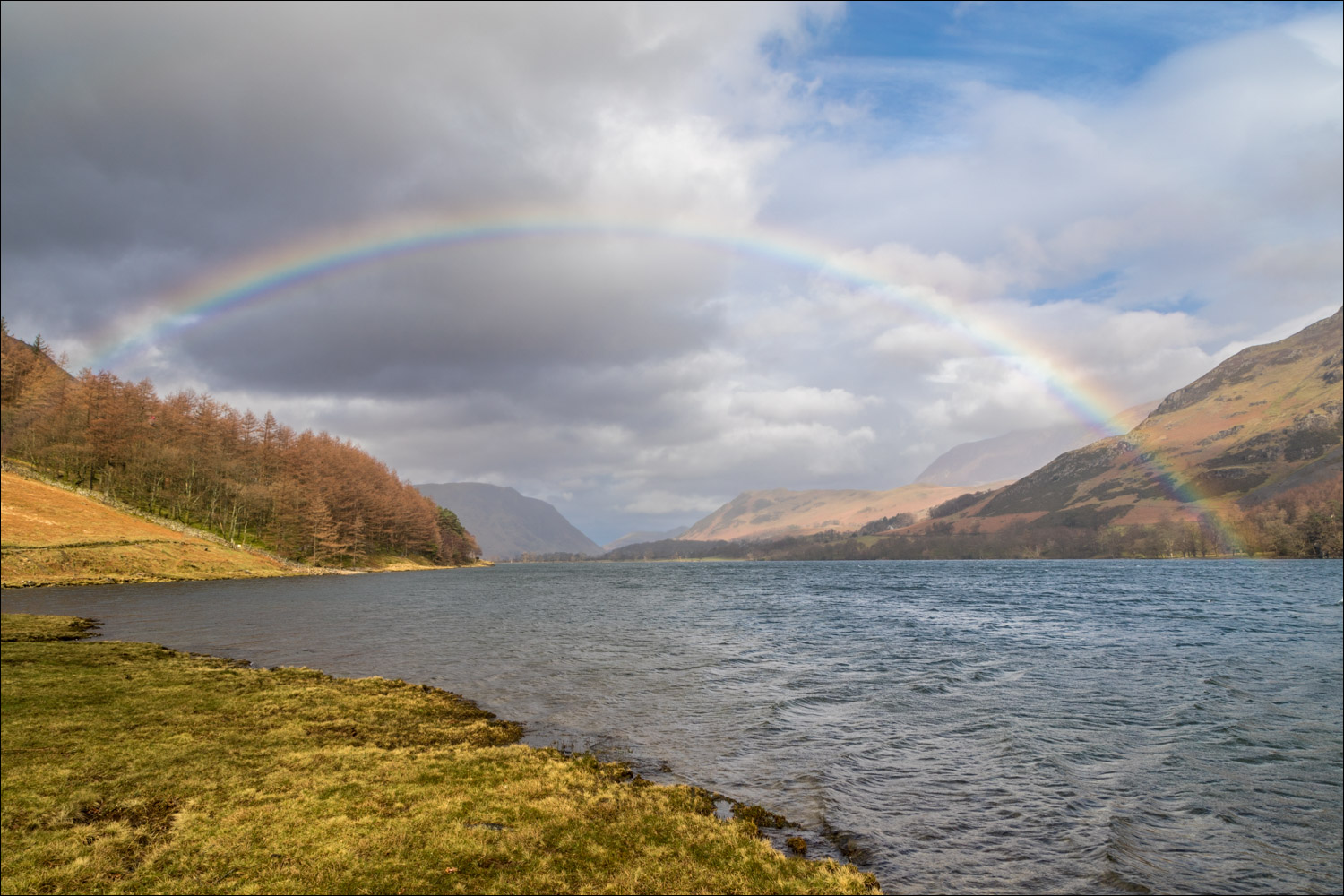
We parked in our usual spot, the National Trust car park at Long How. We walked through Buttermere village and followed the path to the foot of the lake. I always walk around Buttermere in an anti-clockwise direction in order to keep the best views ahead. After crossing the footbridge over Buttermere Dubs we set off along the lakeshore path which leads to the head of Buttermere. Fine drizzle borne by a strong wind from the south made it difficult to take photos in our direction of travel, but there was ample compensation in the form of a rainbow as we looked back to the foot of the lake
After crossing Peggy’s Bridge and passing by Gatesgarth Farm we started the return leg along the other shore, passing through the rock tunnel near Hassness along the way. We continued along the shoreline path and, where it forks off to the foot of the lake, we carried on ahead. This brought us back into Buttermere village to end another wonderful visit to this place
For other walks here, visit my Find Walks page and enter the name in the ‘Search site’ box
Click on the icon below for the route map (subscribers to OS Maps can view detailed maps of the route, visualise it in aerial 3D, and download the GPX file. Non-subscribers will see a base map)

Scroll down – or click on any photo to enlarge it and you can then view as a slideshow

Having left the car park at Long How we walk through Buttermere village

Path to the lake

Looking back to Buttermere village

We walk across the foot of the lake towards Sourmilk Gill

Foot of Buttermere

Whiteless Pike and Buttermere village below

Looking back along the path

Burtness Wood

A rainbow appears over the lake

Hassness on the far side of Buttermere


Hassness again as we follow the lakeshore path (and ignore a shortcut which leaves the lakeside)


Looking across Buttermere

We pass by Horse Close


Memorial bench looking up Comb Beck to High Stile

Walking into rain and high winds towards Fleetwith Pike and the head of Buttermere

We cross Peggy's Bridge at the head of the lake

Warnscale Beck from the bridge

Looking back to High Crag as we follow the path to Gatesgarth

Beyond Gatesgarth, a short road section at the start of the return leg

We pass by the head of Buttermere, with Low Crag beyond


Pine tree at Hassness

Into the rock tunnel....

....and out again

We continue along the shoreline path

Beyond the foot of the lake now and heading back to Buttermere village...


Looking back to Sourmilk Gill and from here it's a short walk back into the village

Cragg House Farm at the end of the walk

Red squirrel later in the day
