
Route: Berwick-upon-Tweed
Area: Northumberland
Date of walk: 17th March 2020
Walkers: Andrew and Gilly
Distance: 2.5 miles
Ascent: 100 feet
Weather: Sunny
Berwick-upon-Tweed sits at the tip of Northumberland, 3 miles from the Scottish Border, and is the northernmost town in England. The peaceful town that exists today is a far cry from Berwick’s turbulent past – it was captured or sacked 13 times before finally falling into English hands in 1482. Berwick’s fortifications were built to keep invading Scots from entering the town
There is plenty of evidence of the town’s chequered history, in particular its medieval town walls, its Elizabethan ramparts, and Britain’s earliest barracks buildings, some of which we’d visit on today’s walk
We parked in one of the public car parks near the old Berwick Bridge. After passing through an arch we climbed up some steps and arrived at the top of Fisher’s Rampart to start the walk around the fortifications, which are well preserved by English Heritage. These massive defences were built between 1558 and 1570 in the reigns of Mary I and Elizabeth I, and were designed to mount guns to defend the town at a time of conflict between England and Scotland
The walk around the town walls can be continued, but when we arrived above the golf course we decided to follow the path across it, which leads to the Berwickshire Coastal Path. A huge and unsightly static caravan park along the cliffs deterred us from venturing further north, and so we turned south along the coastal path at this point to start the return leg
After following the path beside the golf course for a while we descended to the beach and walked along it for a short distance, before heading back into Berwick and retracing our steps to the end. Although it was the end of the walk, it wasn’t the end of the day, and there still remained enough time for another walk on nearby Holy Island, click here for that
Click on the icon below for the route map (subscribers to OS Maps can view detailed maps of the route, visualise it in aerial 3D, and download the GPX file. Non-subscribers will see a base map)

Scroll down – or click on any photo to enlarge it and you can then view as a slideshow

Looking along Sandgate as we leave Quay Wall car park

Two road bridges and a railway bridge over the River Tweed

We pass by the 18C Main Guard - the guard house housed troops who organised town security, and was relocated here from Marygate in 1815

We follow a path around the fortified quay walls


Views from the walls...


We look along our return route from the walls

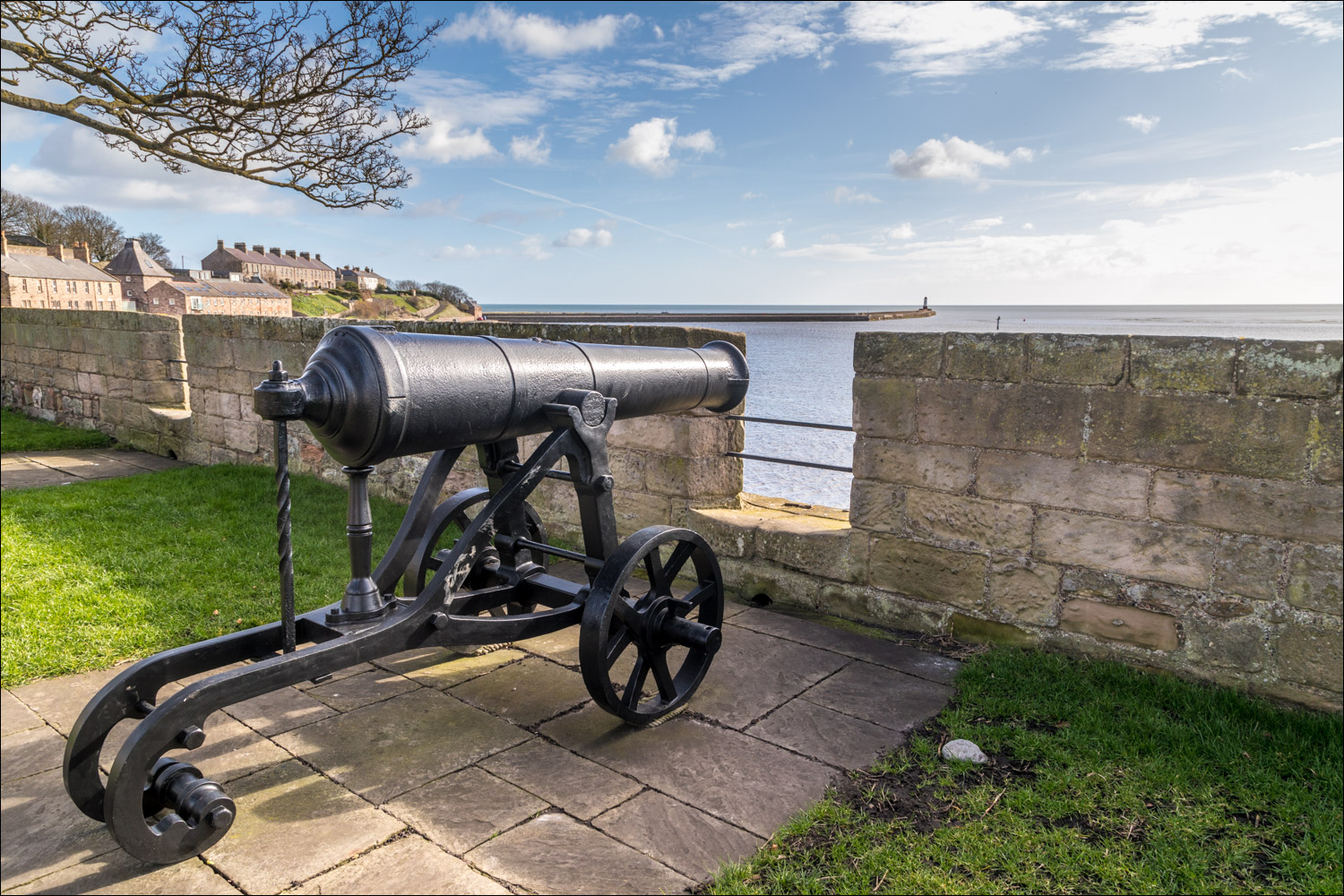
We enter the Ramparts, defences which were built between 1558 and 1570 in the reigns of Mary I and Elizabeth I

Looking back over Berwick

The Ramparts were designed to mount guns to defend the town at a time of conflict between England and Scotland, although they have never experienced a shot in anger


The garrison, built in about 1750 to store gunpowder

Further along the Ramparts

Looking out to sea across Magdalene Fields golf club

A view into town

Further along the Ramparts

The Ramparts continue, but we retrace our steps for a short distance and head towards the coast

We pass through the Cowport Gateway, one of the Elizabethan gates into the town. Gates were the weakest point in defensive walls, and so it was made deliberately small

Sharpers Head from the Berwickshire Coastal Path - the path continues north but we turn south here to start the return leg

Looking across Magdalene Fields to the Ramparts, where we'd walked earlier

A view back along our path

We descend to the beach....


We walk along the beach, with the pier and the lighthouse on our left


A group of oystercatchers

At the end of the short beach section we turn west and head back into the town

The Quay Walls again...


We arrive back at the fortifications and climb the steps to the top of the ramparts

A final view back from the ramparts at the end of a walk steeped in history
Follow the link for more walks in Northumberland (29)
