
Route: Barton Waterside
Area: North Lincolnshire
Date of walk: 25th February 2024
Walkers: Andrew and Gilly
Distance: 4.8 miles
Ascent: 50 feet
Weather: Sunny
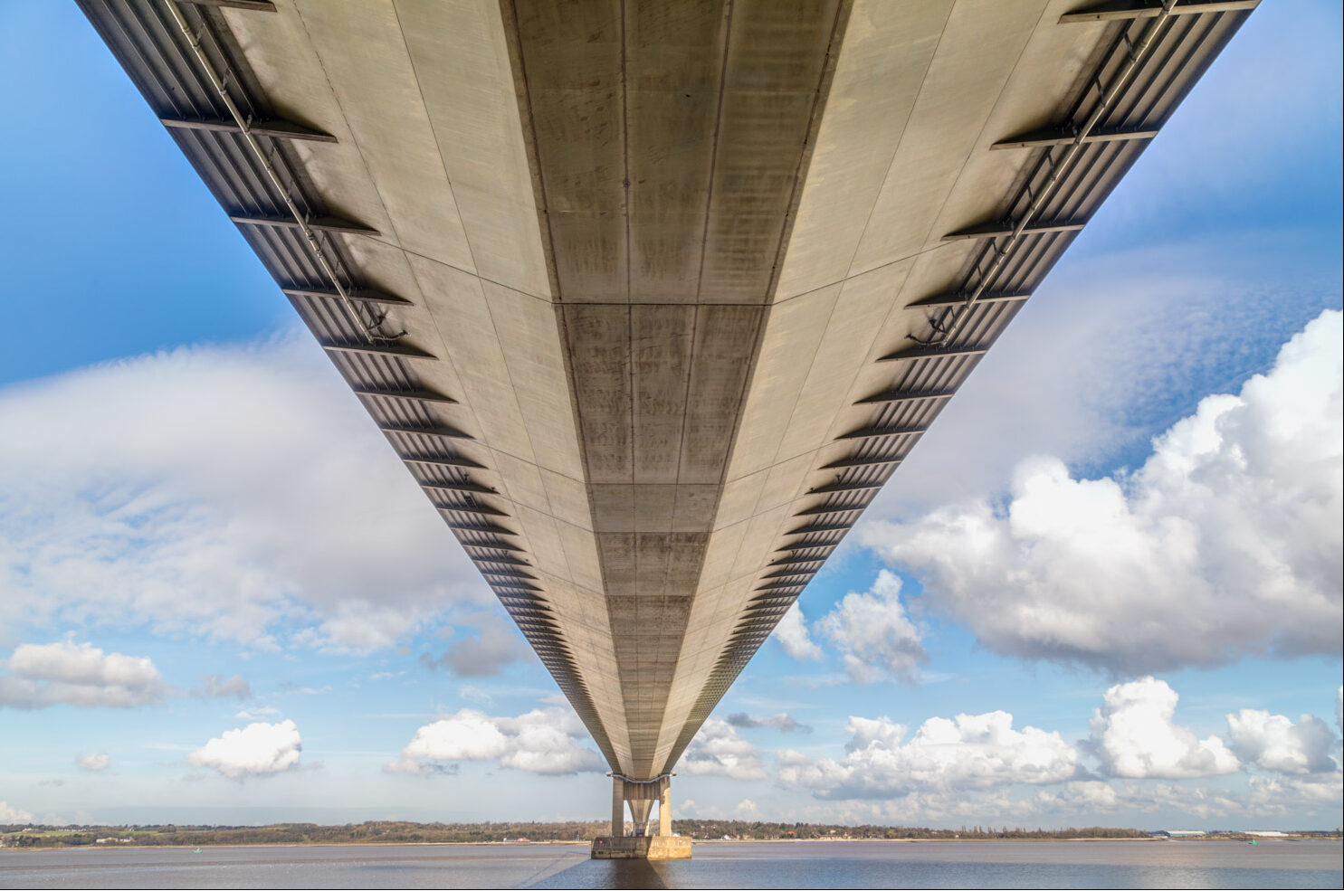
After driving over the Grade I Listed Humber Bridge, which features in many of the photos taken on this walk, we parked at Waters’ Edge Country Park near the bank of the River Humber. This was once one of the most contaminated industrial sites in the UK, with the ground saturated with toxic waste from chemical factories. Since then the area has been transformed into Waters’ Edge Country Park and Local Nature Reserve, and it is now a pristine green space and a haven for wildlife. We crossed the footbridge over the outflow at Barton Waterside and set off along the well made path beside the River Humber, part of the long distance Viking Way. We walked under the Humber Bridge, marvelling at the incredible feat of engineering. The suspension bridge was the longest of its type in the world when it opened in 1981
Further along the easy path we passed by the visitor centre at Far Ings Nature Reserve. This walk can be conveniently linked with a visit to the reserve, home to many rare species including bittern, water vole and Cetti’s warbler. Last time we visited we spotted a kingfisher and a marsh harrier. We didn’t have time for a proper visit today, but I do recommend adding this to the itinerary. Don’t forget to bring binoculars
We continued to head west as far as Chowder Ness, another place where rare birds may be spotted. Beyond Chowder Ness we started the return leg, following a track and then a quiet road as far as Ness End Farm. There’s an alternative entrance into Far Ings here (also a car park) and we took the opportunity to walk through the reserve as far as the visitor centre which we’d passed by earlier. (Note: dogs are not allowed in Far Ings Nature Reserve and anyone with a dog would need to continue along Far Ings Road). After following the path across the reserve we arrived back on the Viking Way and from here we retraced our steps back to the start
For other walks here, visit my Find Walks page and enter the name in the ‘Search site’ box
Click on the icon below for the route map (subscribers to OS Maps can view detailed maps of the route, visualise it in aerial 3D, and download the GPX file. Non-subscribers will see a base map)

Scroll down – or click on any photo to enlarge it and you can then view as a slideshow

The start of the walk as we cross the footbridge over a small creek at Barton Waterside

Once Brown and Clapson’s shipyard in the mid-19th century, the shipyard adjacent to Barton Haven is now dedicated to rebuilding and restoring vintage boats...

The Humber Bridge in the background - we'll be walking under the bridge shortly


We climb up onto the embankment to join the Viking Way heading west...


The Humber Bridge, which joins East Yorkshire to North Lincolnshire and has become a local landmark visible from miles away. The bridge was made a Grade I listed building in 2017 to mark Hull's year as UK City of Culture.

We pass beneath the bridge, which is nearly 1.4 miles long


We continue along the Viking Way, with the River Humber on our right

Looking back

We pass by the Far Ings Nature Reserve visitor centre

Looking across the reserve - it's possible to enter from other places along the route and a diversion is highly recommended

Views back to the Humber Bridge...


We head to the far point of the walk at Chowder Ness...


We turn left at the end of Far Ings


We leave Far Ings Road at Ness End Farm

We enter into Far Ings Nature Reserve and follow a track towards the visitor centre

Views across the reserve, where chains of flooded claypits and reed beds have provided a haven for numerous species of birds


We reach the visitor centre and from here we rejoin the Viking Way and retrace our steps back to the start

The Viking Way Cafe Bar, which is pleased to serve hungry walkers

A final view of the Humber Bridge from Waters' Edge Country Park, and a short video looking back along our route as we drove back over the Humber Bridge...
Follow the link for more walks in Lincolnshire (26)
