
Route: York City Walls
Area: North Yorkshire
Date of walk: 14th April 2026
Walkers: Andrew
Distance: 4.8 miles
Ascent: 100 feet
Weather: Mostly sunny
York City Walls (or “Bar Walls”) are a scheduled ancient monument encircling the historic City of York and comprise two miles of surviving masonry. They are the longest town walls in England. They were built mainly in the 13th century of magnesian limestone. There are four main bars, or fortified gateways, two smaller gateways with more modern stonework and one postern (a very small gateway defended by a tower), frequent intermediate towers, and details such as windows, arrow-slits and gun ports, sculptures, and masons’ marks. Walking the trail around the Walls is roughly like walking the edges of a kilometre square. Each side in this square has a grand medieval fortified gateway called a “bar”. The trail is divided by these bars into four unequal corners (credit to The Friends of York Wall for this and other information, the site is a treasure trove and contains a huge amount of detail about every feature seen along the way)
I parked in the short stay car park at Coppergate, but the walk may be started from anywhere along the route, including the railway station which is close by. I joined the York City Walls at the Fishergate Postern Tower and climbed up the the wall, setting off in an anti-clockwise direction. There is an unprotected drop of about 15 feet along the way. On reaching Red Tower I descended to the pavement as there is no wall for a short section which was once a large marshy lake that neither the Walls nor attackers could easily cross. After walking past Foss Islands I regained the City Walls at Layerthorpe Bridge which leads to Monk Bar. The section beyond Monk Bar was the highlight of the walk, with views of York Minster, looking quite magnificent
The sight of the Minster tempted me to leave the Walls at Bootham Bar and to visit the interior (charges apply). After admiring the awesome architecture I returned to the streets and crossed the River Ouse at Lendal Tower, beyond which I climbed back up to the York City Walls to resume the circuit, passing by the railway station along the way. There were lovely retrospective views of the Minster from here. I continued to Baile Hill, a man-made earth mound and the only remaining feature of the fortification known as the Old Baile. Its origins date back to 1068. I descended from here to cross the River Ouse and, at another section where there is no wall, walked past Clifford’s Tower, the largest surviving part of York Castle, northern England’s greatest medieval fortress. From here it was a short stroll back to Fishergate Postern Tower to complete the circuit, one which had been full of interest every step of the way
Note that the York City Walls walk is 2.8 miles long if followed without deviation. However, there are numerous opportunities to leave the Walls and visit nearby points of interest (hence my walk was nearly 5 miles). The route map shows the Walls walk only and does not reflect my meanderings. Dogs are not allowed on the Walls. The Walls are generally open from 8am, check here for times
Click on the icon below for the route map (subscribers to OS Maps can view detailed maps of the route, visualise it in aerial 3D, and download the GPX file. Non-subscribers will see a base map)

Scroll down – or click on any photo to enlarge it and you can then view as a slideshow

The start of today's York City Walls circuit - Fishergate Bar, one of the six gateways. I climb onto the Walls here

I set off anti-clockwise in the direction of Walmgate Bar...


Red Tower, built in 1490, and used as a watchtower. From here there is a short section without a defensive wall. It was not necessary to build one, as the area was a swamp known as King's Pool which formed an impassable defence

I walk beside the River Foss, with a small nature reserve on the left

I climb back onto the York City Walls at Layerthorpe Bridge

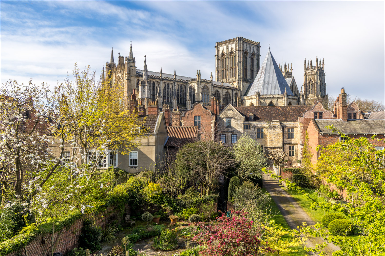
York Minster comes into view

York Minster towering over the rooftops

Monk Bar ahead

Monk Bar, one of the four main gateways

At the other side of Monk Bar I climb back up to the ramparts

Wonderful views of York Minster as I continue along the Walls...

The grounds of Grays Court

I pass by a 'pepperpot tower', added by the Victorians, at one of the interval towers along the way

A change of direction as I head towards Bootham Bar, giving fresh views of York Minster in all its glory

I continue towads Bootham Bar...


Looking through the ramparts to the streets of York

York Minster again

Bootham Bar, where I descend from the Walls to make a short detour

I walk past an elegant terrace of houses in St Leonard's Place

I turn left into Duncombe Place and head towards York Minster

I walk through Dean's Park, home to the Cathedral Library

I walk around the Minster

College Street

Interior of York Minster, a magnificent Gothic cathedral with a history dating back to the 7th century...


The Great West Window, dating back to 1338 and known as 'The Heart of Yorkshire'

The Grand Organ Case

Ornate wall monument dedicated to Sir Henry Belasyse (1555–1624), located in the north quire aisle

The Chapel of St John, which serves as the Regimental Memorial Chapel for the King's Own Yorkshire Light Infantry

After leaving the Minster, I cross the River Ouse via Lendal Bridge, here looking back to Barker Tower

Another view back to Barker Tower, with York Minster in the background

The York City Walls walk resumes beyond the River Ouse

Looking back to York Minster

York Railway Station, which would be a perfect start point for the walk for anyone arriving by train

Another view back along the Walls

Streets of York seen from the Walls

Micklegate Bar, another of the four ancient gateways into York

The Church of St Mary, Bishophill Junior, a Grade I listed parish church

Spring blossom and daffodils enhancing the surroundings along this section of the Walls

Another street scene

York Minster behind a mass of cherry blossom


I turn left at a corner tower and head towards Baile Hill

Looking down to the Walls from the top of Baile Hill. This is the only remaining feature of the fortification known as the Old Baile. Its origins date back to 1068

Looking back to Baile Hill and Baile Tower. The Walls end here briefly as the River Ouse intervenes

I cross the River Ouse via Skeldergate Bridge

Looking along the River Ouse

I walk past Clifford's Tower and just beyond it I arrive back at Fishergate Postern Tower to complete the circuit of York City Walls
