
Route: Wharram Percy
Area: North Yorkshire
Date of walk: 11th March 2019
Walkers: Andrew
Distance: 6.9 miles
Ascent: 600 feet
Weather: sunny, with a cold strong wind
Wharram Percy is among the biggest and best-preserved of the thousands of deserted medieval villages in Britain. The surrounding area is well served by a network of footpaths, giving various possible routes for a circular walk visiting this fascinating place
I parked in the nearby village of Wharram le Street, and after a short diversion to the lovely church of St Mary’s turned off the road to join the Yorkshire Wolds Way. It was a glorious morning, and the big skies enhanced the rolling chalk landscape. I followed a farm track across a field, and then joined a quiet country lane which passed by Bella Farm. Just beyond the farm the Centenary Way provides a shortcut to Wharram Percy, but the weather was far too good today and so I continued straight ahead
A little further on, another shortcut presented itself but again I declined the opportunity and departed from the Wolds Way to follow a public footpath along Raisthorpe Wold. There were some sweeping views over the surrounding countryside, and it was a worthwhile detour in weather like this. I rejoined the Wolds Way which took me above the rim of Deep Dale, a beautiful section of the walk. On rounding a corner St Martin’s Church came into view. This is the only building which still stands in Wharram Percy, and is set in a wonderful position at the foot of the dale and beyond an ancient millpond
I descended to the former village and wandered around the site for a while. There are various information boards which outline the locations of the former medieval houses, cottages and paddocks. Extensive research has been carried out here, and evidence of pre-historic and Roman occupation has been uncovered
Beyond Wharram Percy I followed a track to Station House and here forked off to the right to follow Station Road back into Wharram le Street to end a superb walk
For other walks here, visit my Find Walks page and enter the name in the ‘Search site’ box
Click on the icon below for the route map (subscribers to OS Maps can view detailed maps of the route, visualise it in aerial 3D, and download the GPX file. Non-subscribers will see a base map)

Scroll down – or click on any photo to enlarge it and you can then view as a slideshow

The start of the walk - I parked by this information board after turning off the B1248

As I walked through the village I made a short detour to St Mary's Church

At a signpost I join the Yorkshire Wolds Way and follow this track

I then join a quiet country lane which leads in the same direction

Looking back to Wharram le Street

Big skies enhancing the rolling chalk landscape

Looking across the dale towards Birdsall Wold...


Just beyond Bella Farm, a shortcut to Wharram Percy presents itself, but I ignore the sign and carry on straight ahead


Looking back along the lane, part of the Centenary Way

I follow the lane towards the woodland on the right

I then leave the lane to briefly join the Yorkshire Wolds Way again...


Looking across to a disused quarry near Fairy Dale

Walking along Raisthorpe Wold

Huge views over the surrounding wolds...


Rolling fields

I rejoin the Yorkshire Wolds Way here, with a view across to Wharram Percy Farm

A delightful section of the walk as the path takes me around the rim of Deep Dale...


Looking back

Looking along Deep Dale...

...and another view back along the dale


Wharram Percy Farm on the right

Wharram Percy comes into view at the end of the chalk lane below

Deep Dale below

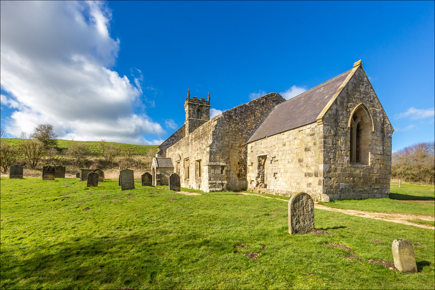
The ruins of St Martin's Church, Wharram Percy

I cross the bridge over the old millpond

The ruined church is the last standing medi building. Around it are the grassed-over foundations of two manor houses and about 40 peasant houses and their outbuildings

The gravestones still standing date from the 18th century onwards, but nearly 700 medi skeletons have been excavated and studied

The church is one of the most thoroughly studied parish churches in England...

...it was completely rebuilt in the 12th century, enlarged during the 13th and 14th centuries, and reduced in the 15th or 16th centuries, when the village was deserted

Inside the church...

The south wall, which shows the stonework of several phases in the Middle Ages

I walk by some cottages, built around 1850 on the site of an earlier farm house...


After a short distance I join Station Road

Wharram le Street ahead...

Follow the link for more walks in North Yorkshire (151)
