
Route: Walla Crag
Area: Central Lake District
Date of walk: 13th October 2022
Walkers: Andrew
Distance: 3.6 miles
Ascent: 1,000 feet
Weather: Sunshine and blue skies
Walla Crag near Keswick is a fell which I’ve often climbed, and one which I could never tire of. There’s a wonderful panorama over Derwent Water and Keswick from the top and good views into the heart of Borrowdale on the way down
I parked in the National Trust car park at Great Wood and followed the footpath heading south along the wood. I ignored the first sign pointing to Walla Crag, which leads to the summit via a more circuitous but gentler route. I carried on a little further until I reached the bridge over Cat Gill. Until recently there was a sign here ‘Cat Gill – very steep!’ It’s now been removed, possibly because the exclamation mark exaggerates the difficulty
The Cat Gill path is indeed quite steep and rocky (and is much easier to ascend than descend) but there are no dangers. Hands aren’t needed and it provides a very quick way to the top. Much of the path is a rocky staircase, part man made and part natural. There are some attractive waterfalls along the way. Before long I arrived at Lady’s Rake from where it’s a short stroll to the summit. From here there are superb views over Derwent Water and to Bassenthwaite Lake beyond. Bright sun and a cloudless blue sky meant that the light was poor for photography, but it was a lovely panorama nonetheless
I retraced my steps for a short distance and then joined the path which leads up to Bleaberry Fell, but soon branched off that to walk above Falcon Crag in the direction of Borrowdale. There are lovely views into the valley from here. I descended gently to Ashness Bridge, a popular (and in my opinion rather overrated) beauty spot, where I took the obligatory photo to add to the thousands that have been taken from here
This marked the start of the return leg and, from the bridge, I followed a path above the road and below Falcon Crag, with views over Derwent Water all the way. The path brought me back to Cat Gill and after crossing the footbridge I retraced my steps to the start
For other walks here, visit my Find Walks page and enter the name in the ‘Search site’ box
Click on the icon below for the route map (subscribers to OS Maps can view detailed maps of the route, visualise it in aerial 3D, and download the GPX file. Non-subscribers will see a base map)

Scroll down – or click on any photo to enlarge it and you can then view as a slideshow

The day before the walk, autumnal colours in the acer glade at Thorp Perrow Arboretum

The start of today's walk as I follow the path away from the National Trust car park in Great Wood

I ignore the first sign for Walla Crag, which provides a gentler but longer way up

I turn left uphill just before the waterfall in Cat Gill

The path follows the course of Cat Gill for much of the way

Looking back to Derwent Water as the gradient finally eases

A grassy area below the summit

Looking back along the path

I cross the stile leading onto the summit area

Derwent Water from the summit of Walla Crag (for a wider panorama scroll down to the video at the end)

I descend from the summit and head towards the Borrowdale fells in the distance

I re-cross the stile. Bleaberry Fell is up on the left

The moon over Derwent Water as I pass above Cat Gill

Looking back to Walla Crag and the ascent path beside the dry stone wall. The crag itself is unseen beyond the trees

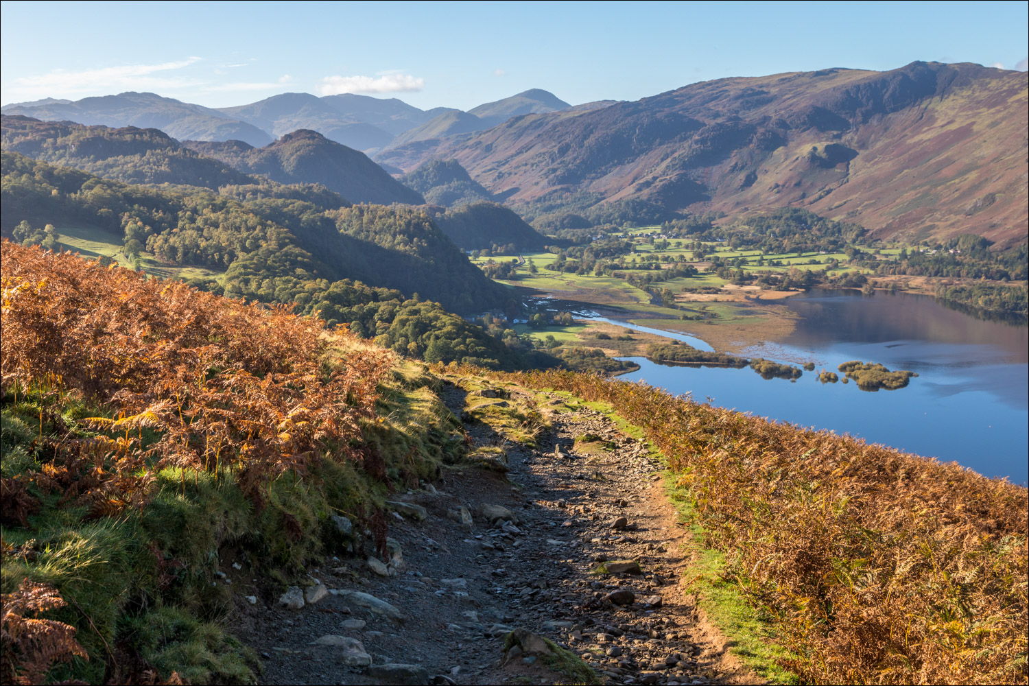
Borrowdale and the head of Derwent Water

Barrow Bay below, with Cat Bells and Maiden Moor on the far side of the lake

The path starts to descend gently

The head of Derwent Water

Borrowdale

I follow the path to the line of trees below, and will turn right on reaching it

Strutta Wood

I arrive at Ashness Bridge and follow the road for a few yards before turning off to join a path on the right

I continue along the fellside, ignoring another route up to Walla Crag

Looking back to Strutta Wood and the head of Derwent Water...


Cat Bells in the foreground and the distinctive pointed top of Causey Pike beyond

Cat Bells and Maiden Moor

Early autumn colours looking across Derwent Water...


A final glance back as I re-enter Great Wood and retrace my steps to the start
