
Route: Sutton Bank
Area: North Yorkshire
Date of walk: 24th May 2019
Walkers: Andrew and Gilly
Distance: 8.8 miles
Ascent: 1,200 feet
Weather: Sunny and warm
Today’s walk was one we’ve had in mind for some time, one which we’d been saving up for a clear day. The view from the spectacular escarpment of Sutton Bank is often cited as being ‘England’s finest’ and we were keen to put this claim to the test
We parked in the National Park Centre at the top of the road up Sutton Bank, one of the most notorious ascents in the country, with a hairpin bend in the middle of a 1 in 4 gradient. We crossed the road to follow the path which runs along the edge of the escarpment, and within a few minutes of setting off were rewarded with some spectacular views over huge swathes of Yorkshire
We continued past the airfield of the Yorkshire Gliding Club, witnessing a take off as we did so, and carried on along the edge as far as the White Horse of Kilburn. This figure of a white horse said to be the largest and most northerly hill figure in England, but the view of it from 10 miles away is better than the one we had from 10 feet away – seen at close range, it’s hard to discern the outline of a horse, so large is the figure
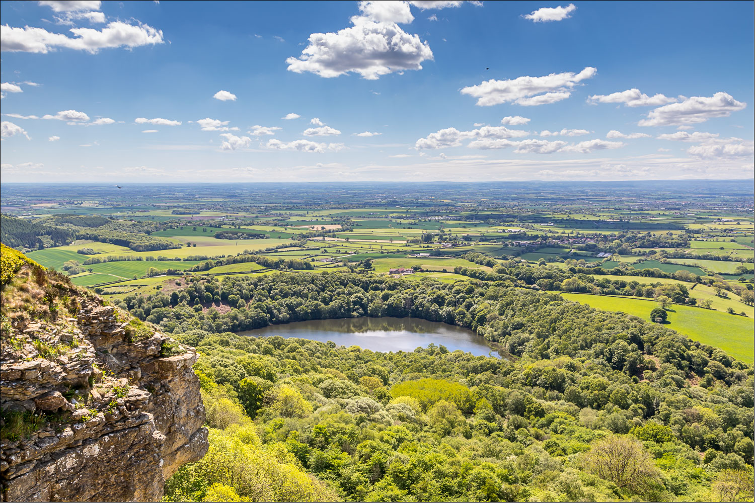
At this point we started the descent from Sutton Bank down a steep flight of steps, and at the bottom we reversed our direction of travel from south to north. We followed a succession of paths through woodland and fields and eventually arrived at the A170 – the foot of Sutton Bank as far as motorists are concerned. An otherwise 5 star walk loses 1 star here, as we had to follow the grass verge beside the busy road for about 10 minutes. It was a relief to turn off and follow the path past Gormire Lake, a tranquil place set in the woods
Beyond the lake we passed by Southwoods Lodge to start the climb back up to the top of Sutton Bank. This wasn’t as steep as we’d anticipated, although we were by now about 7 miles into the walk, so it was quite tiring in the hot conditions. We finally arrived back on the escarpment and joined a heavenly path, part of the Cleveland Way. The path followed the edge of the cliffs, with astounding views over the surrounding countryside. We arrived at a noticeboard indicating ‘The Finest View in England’, and after admiring it for a final time made our way back to the nearby Visitor Centre to end a fabulous walk
Click on the icon below for the route map (subscribers to OS Maps can view detailed maps of the route, visualise it in aerial 3D, and download the GPX file. Non-subscribers will see a base map)

Scroll down – or click on any photo to enlarge it and you can then view as a slideshow

Having left the visitor centre and crossed over the A170 we set off along the top of Sutton Bank, following a section of the Cleveland Way

Hood Hill and an appetiser for the huge views to come

We follow the path along the escarpment

Looking down to the A170 , which we'll cross later on at the half way point of the walk

One of several benches with a view along the way

We pass by the site of the Yorkshire Gliding Club, formed in 1934

Good timing, as a glider takes off above our path...


Huge views, for 40 miles or so, as we continue along the escarpment...


Hood Hill

Another bench with a view


We arrive at the site of the White Horse of Kilburn - the notice board shows what it looks like from afar

Seen close up, it's impossible to distinguish the outline

At this point we descend down a steep flight of stairs which leads to a twisting road

We leave the road just around this corner

We follow a track through Hood Hill Plantation...


Looking back up to Sutton Bank

The far end of the escarpment, which will be our return route

We head towards Hood Grange

Looking back along the path

Beyond Hood Grange we cross this stile - beyond it is the only unsatisfactory part of the route...

...a 10 minute walk beside the A170, which we leave around the corner ahead

It's a relief to leave the road behind and to follow the path past Gormire Farm

Gormire Lake, and a welcome opportunity for Bonnie to cool down

The lake is unusual in that it has no inflow or outflow, and is thought to be fed by an underground spring and drained by a limestone channel

We head towards Southwoods Lodge

A sign of the climb to come

We follow the path past Southwoods Hall...


The start of the climb back up to Sutton Bank

There's no clear path, but navigation is assisted by the occasional post


Views back as we gain height...


The climbing is over as we reach Sutton Bank

Back on the Cleveland Way, and the rest of the walk is an easy stroll with some heavenly views...


Hood Hill and Gormire Lake below

Wensleydale in the far distance, at a guess some 40 miles away


Whitestone Cliff

Panorama - click to view

Gormire Lake again


Click for a wider view

'The Finest View in England'
Follow the link for more walks in North Yorkshire (151)
