
Route: Ponta do Pargo circuit
Area: Western Madeira
Date of walk: 26th April 2022
Walkers: Andrew and Gilly
Distance: 8.2 miles
Ascent: 1,500 feet
Weather: Sunny
On the second day of our walking holiday in Madeira we decided on another coastal walk, having been inspired by yesterday’s wonderful outing. We drove to the sleepy village of Ponta do Pargo on the western tip of Madeira and parked on the roadside near the village church
We walked back through the village with the sea on our left and joined a narrow concrete road leading in and out of a verdant gully, with views out to sea. We then followed a cobbled path uphill to meet the Levada Nova da Calheta, a good example of the levada system which irrigates the island, but which also provides wonderful opportunities for walkers. A levada is a narrow man made channel which carries water. The system dates back to the fifteenth century and is unique in the world. The purpose of this vast network of stone channels is to capture the water falling in the mountains and carry it down to the crop fields. Madeira’s climate is such that the lower cultivated areas are dry, but there is abundant rain in the afforested mountain areas which are unfit for cultivation. As a result, and after 500 years of effort, 1,400 miles of canals and 25 miles of tunnels have been constructed, mostly by hand and often in such difficult terrain that men had to work while suspended on ropes above sheer drops
The path beside the levada weaved its way in and out of gullies, descending at an imperceptible gradient, until we finally arrived at its northern most tip. We then joined a quiet road which took us downhill through the hamlet of Cabo to the wonderfully situated Chapel of Nossa Senhora da Boa Morte. We took a short there and back detour here along a rocky path to a mirador, where there is a small viewpoint with a big view along the coastline – a perfect picnic spot
After retracing our steps we joined a track which contoured around the top of the cliffs and which turned into a road, passing through the largely abandoned hamlet of Serrado. From here we followed quiet lanes back to the start, retracing our steps for a while when we reached Pedregal. It had been another wonderful walk on the island
Click on the icon below for the route map
![]()
Scroll down – or click on any photo to enlarge it and you can then view as a slideshow

The start of the walk from the village church at Ponta do Pargo

We leave the village via a narrow concrete road known as Caminho Velho

We follow the road into a gully

At the head of the gully we cross this bridge and head uphill towards the hamlet of Pedregal

The Atlantic beyond the terraced fields on our left

Looking back to Ponta do Pargo

On reaching Pedregal we follow the sign for the levada and walk up Caminho Pedregal

One of many Bird of Paradise flowers, the national flower of Madeira

We pass by this ruined building

A woodland section along the Caminho do Pedregal

We join the Levada Nova

As with all levadas, the gradient is very gentle so as to keep the water flow as slow as possible. This makes for easy walking

Looking out to sea

The levada weaves its way in and out of gullies, following the contours as closely as possible...


Looking across the valley

Ribeira da Vaca below

The damp walls by the levadas are a haven for mosses, fern, lichen and erigeron...


We join a quiet road heading for the hamlet of Cabo

Agapanthus was growing in profusion, but we were a couple of weeks too early, and only a few were in flower

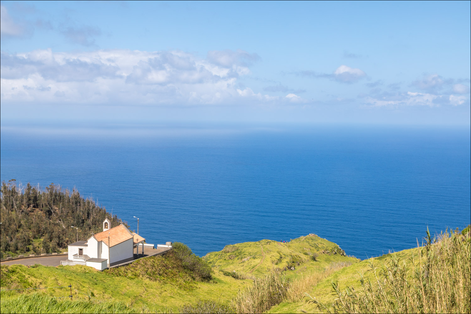
We arrive in Cabo and follow the sign to its chapel

We descend to the idyllically situated Chapel of Nossa Senhora da Boa Morte, founded in 1666, and walk to the mirador beyond it

The Miradouro de Boa Morte...

...and the view from it

Madeira's coastline is extremely rugged, and some of the highest sea cliffs in the world are to be found here

After enjoying a picnic at the chapel, we start the return leg of the walk and join a dirt track known as Caminho da Capela do Cabo

Looking towards Ponta do Pargo

Further along the track, which is known as Caminho da Cruz at this point

We pass through the hamlet of Lombarda Velho

We follow another track known as Caminho Velho

Looking back along Caminho Velho

Ruined buildings at the edge of Pedregal...


On arriving in Pedregal the circuit is complete and from here we retrace our steps back to the start

Ponta do Pargo ahead

We arrive back at the village church and the end of a superb walk

The Miradouro do Fio is nearby and we took a short detour in the car to admire the view along the coast
Follow the link for more walks in Madeira (17)
