
Route: Place Fell
Area: Far Eastern Lake District
Date of walk: 1st April 2022
Walkers: Andrew
Distance: 4.9 miles
Ascent: 1,900 feet
Weather: Mostly sunny, clear light, snow on the tops
It’s been five years since I was last up Place Fell – far too long an interlude for such a superb fell. Instead of following the obvious route from Boredale Hause and along Steel Edge, I decided to repeat the little known route I’d walked last time, which I’d really enjoyed.
I made an early start and was lucky to bag one of the few free parking spaces in front of the George Starkey Hut. There’s a public car park in Patterdale if necessary. I followed the track to Side Farm, which starts from beside the hut. The wonderful path along the shore of Ullswater – one of the best in the Lake District – runs past the farm, and it was with reluctance that I left it after a short distance to start the climb up to Place Fell
The path leads through an area shown on the OS map as Hare Shaw and it’s clearly not used very often, though the route was never in doubt. Thanks to some sun and blue skies, and snow on the higher fell tops, I was able to enjoy spectacular views back over Ullswater
Beyond Hare Shaw I gained the summit ridge and started the ascent to the top of the fell. The path was covered in snow and I may have strayed from it from time to time, but there were no difficulties and before long I reached the summit cairn. Although it was very chilly up there, the views were stunning, shown at their best in perfect light and with a covering of snow on the higher tops
I set off on the descent to Boredale Hause, an easy way down, though there is one short steep gully where hands may be needed. The views during the descent, especially those into the side valleys of Grisedale and Deepdale, were wonderful. All too soon I arrived back at Side Farm and from here I retraced my steps to the end of a five star walk
For other walks here, visit my Find Walks page and enter the name in the ‘Search site’ box
Click on the icon below for the route map (subscribers to OS Maps can view detailed maps of the route, visualise it in aerial 3D, and download the GPX file. Non-subscribers will see a base map)

Scroll down – or click on any photo to enlarge it and you can then view as a slideshow

The start of the walk as I follow the track to Side Farm and cross the bridge over Goldrill Beck

Side Farm and the lower slopes of Place Fell ahead

Looking back to Patterdale

Beyond Side Farm I join the wonderful path beside Ullswater

Looking across the head of Ullswater to Glenridding

Just beyond this old barn, I seek out the faint ascent path, which is the key to the walk

Finding the path is much easier, thanks to the Artist's Seat which has been installed since I was last here. The inion reads 'Three artists J M W Turner, Ann Macbeth & John Glover were inspired by this landscape'

At the Artist's Seat I leave the shoreline path to join a higher one, which I leave almost immediately to follow the faint path on the right at this junction

Looking back down the path to the head of Ullswater

I reach Hare Shaw, from where there is a wonderful view over Ullswater and the eastern fells, including Helvellyn...

Beyond Hare Shaw I encounter light snow on the ground as I make my way up to Place Fell...


Looking across to Striding Edge, Helvellyn and Catsycam

A steeper section near the top


Looking back along the path to the foot of Ullswater and the Pennines beyond

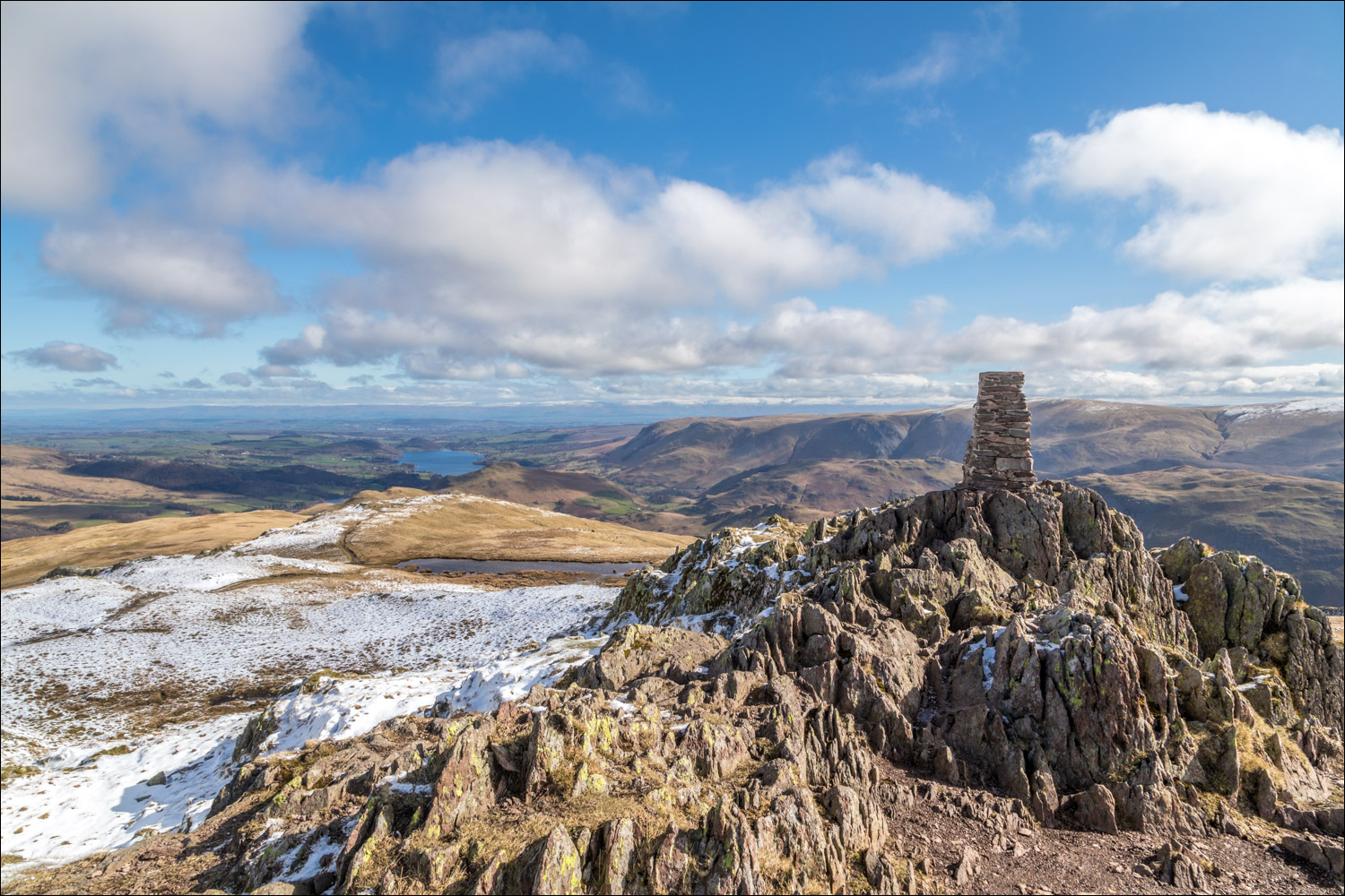
OS trig column at the summit of Place Fell

Looking down to Grisedale and Glenridding

A closer view of Glenridding, with Helvellyn to the left

A wonderful scene, but it was time to be heading down...

I head south in the direction of Boredale Hause. This is a popular way up the fell, so the path is never in doubt

I pass by a small tarn

Brothers Water and Deepdale come into view

I aim for a cairn on the subsidiary top of Round How

Brothers Water and Deepdale again

The small cairn on Round How

I clamber down a steep gully, the only slightly awkward part of the descent

Snow patterns on the far eastern fells

Boredale Hause, an important junction, comes into view at the depression below

An improved path provides an easy descent to the hause

Boredale Hause, where I turn right. There's a choice of two paths, which merge lower down

Arnison Crag and Birks above Deepdale

A closer view along Deepdale

Ullswater and Patterdale come into view as the path gradually descends down to the valley

Deepdale again

The small settlement of Rooking below

I follow the path back towards Side Farm

Patterdale, and the track back to the start...


A final glance back to Side Farm and the lower slopes of Place Fell at the end of a fantastic walk
